Long-distance walk in the Mullerthal
The Mullerthal Trail, three loops through Luxembourg's rocks
The Mullerthal Trail is the waymarked long-distance path of Luxembourg's Mullerthal region, about 112 km in three circular routes. Route 1 is 36.7 km, Route 2 39.7 km and Route 3 37.7 km according to the operator, and each takes two days. It carries the Leading Quality Trails - Best of Europe label, and free buses reach it from Luxembourg City.
In 30 seconds
Full read: 4 min
- The Mullerthal Trail covers about 112 km in three circular routes through eastern Luxembourg.
- Route 1 is 36.7 km, Route 2 39.7 km and Route 3 37.7 km, each walkable in two days.
- The operator's six-stage plan starts and ends in Echternach, with days of 13.2 to 25.3 km.
- It holds the Leading Quality Trails - Best of Europe label and is reachable by free bus.
If I could only walk one, I'd pick Route 2 and split it at Müllerthal. Short on time? Do Echternach to Berdorf, 6.8 km taking in the Wolfsschlucht, the Perekop and the Hohllay. For me it's the best stretch of the whole trail.

Before you go
What I would keep in mind
-
01 Most beautiful
Echternach to Berdorf in a morning
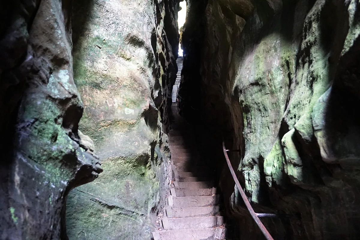
This 6.8 km stretch climbs to the Troosskneppchen viewpoint, then threads the Wolfsschlucht, the rock labyrinth, the Perekop and the Hohllay before reaching Berdorf. The trail website puts it at 2 to 2.5 hours.
Wolfsschlucht gorge -
02 To save money
Free buses to the trailheads
Public transport is free across Luxembourg, so you can leave the car, walk a linear stage and ride back. The trail website suggests exactly that.
Echternach -
03 My tip
Pack a torch for the Kuelscheier
Between Müllerthal and Consdorf, Route 2 squeezes through the Kuelscheier, a narrow and pitch-dark cleft. The official site recommends a torch; you can walk round it if it's too tight.
-
04 Worth the splurge
A night in Müllerthal
The hamlet of Müllerthal is where Routes 2 and 3 meet. Sleep there and you'll have the Schiessentümpel waterfall to yourself first thing, before the car park fills.
Waldbillig
What I would book
6 days
The Mullerthal Trail in six stages, as the operator suggests
- Day 1
Echternach to Moersdorf, 18.7 km
From the basilica through the abbey courtyard and park, along the Sûre and up into the woods. A viewpoint above Steinheim, Rosport with its Tudor Museum, and the 14th-century Girsterklaus chapel.
- Day 2
Moersdorf to Echternach, 19.5 km
The Déiwelskopp nature reserve, a steep climb for views over the Sûre, then Mompach and Herborn. Back through the Hierberbësch forest reserve and past Echternach lake.
- Day 3
Echternach to Müllerthal, 13.2 km
The shortest day and my favourite. Troosskneppchen, the Wolfsschlucht, the labyrinth, the Perekop, the Hohllay and the amphitheatre to Berdorf, then through the Schnellert woods to the Heringer Millen.
- Day 4
Müllerthal to Larochette, 18.1 km
The Schiessentümpel, a timber staircase of about 90 m that seems to float, the Kallektuffquell tufa spring, and over from the Black Ernz to the White Ernz and Larochette's castle.
- Day 5
Larochette to Müllerthal, 20.2 km
Castle to castle. A plateau with a 360-degree view, the old Klingelbuer wash house and Beaufort's two castles, then back along the Haupeschbaach and Halerbaach streams.
- Day 6
Müllerthal to Echternach, 25.3 km
The longest day. The Eilebuerg and Goldfralee rocks, the Rittergang and Déiwepëtz clefts, the Kuelscheier, the Bildchen oak, Scheidgen and the descent into Echternach.
Times are a guide, based on the official opening hours checked for this guide.
Some long-distance paths are about the miles. The Mullerthal Trail is about what’s round the next bend. In under 40 km it takes you through sandstone gorges, up iron ladders inside a crack in the rock, into caves where millstones were cut, like the Hohllay cave, past a waterfall with a stone bridge and on to two castles. And it does all that without any serious climbing, as the highest point on the whole network is 420 m.
Three loops that share a hub
The trail runs to roughly 112 km split into three circular routes that link up. Route 1, 36.7 km, heads from Echternach towards the Sûre, Rosport, Moersdorf and Herborn through woods, valley views and orchards. Route 2, 39.7 km, is the rock route through Berdorf, the hamlet of Müllerthal, Hersberg and Scheidgen. Route 3, 37.7 km, starts in Müllerthal and pairs the Black and White Ernz valleys with the castles at Beaufort and Larochette.
Those distances come from the operator, mullerthal-trail.lu. The government portal rounds them to 36, 38 and 38 km, so don’t be thrown if you see both. Each route can be walked over two days, and the website also sets out a full circuit in six stages.
Only one day? Here’s what I’d walk
Route 2, without much hesitation. It’s the one that takes in the Wolfsschlucht gorge, the Perekop, the Hohllay, the Werschrummschlëff maze, the Schiessentümpel and the Kuelscheier cleft. If the whole loop feels like a lot, and an estimated 12 h 50 is a lot, walk Echternach to Berdorf, 6.8 km that the site reckons at two to two and a half hours. Up in Berdorf there’s a bus back.
Route 3 would be my second choice, especially in autumn. It has the roughly 90 m timber staircase above the Black Ernz, the 700 m boardwalk to the Kallektuffquell tufa spring and Beaufort Castle, where the website suggests stopping to taste Cassero, the blackcurrant liqueur still made at the Renaissance castle.
Once your dates are set, check which hotels are still free in Echternach before prices climb.
Six days, village to village
The operator’s plan splits the 112 km into six stages of 13.2 to 25.3 km, starting and ending in Echternach with nights in Moersdorf, Echternach, Müllerthal, Larochette and Müllerthal again. You’ll find it laid out in the itinerary on this page. If you’d rather not change beds every night, the same site suggests doing the trail from a single base, since buses cover the region well. It names Beaufort, Berdorf, Heffingen-Soup and Scheidgen as bases right on the route. Either way, the operator’s advice is to book your beds in advance and check ahead when the restaurants and places to buy food along the day’s stage are open.
Getting there from the UK and the capital
From London, the straightforward way is Eurostar to Brussels or Paris and then on to Luxembourg City by train; the trail website notes the TGV from Paris-Est takes about two hours. Once in Luxembourg, public transport is free for everyone. From Luxembourg City the direct 201, or the slower 211 and 212, run every half hour to Echternach from the Kirchberg Luxexpo tram stop. Coming from Trier, the site suggests the train to Wasserbillig and the 271 bus. I’d check the day’s times on mobiliteit.lu, as lines change.
Drivers can use the car park at Echternach bus station, which the Route 1 sheet lists as the parking spot. And if you don’t fancy carrying a big pack, the site advertises a luggage transfer service between overnight stops.
Once your dates are set, check which hotels are still free in Echternach before prices climb.
Before you set off
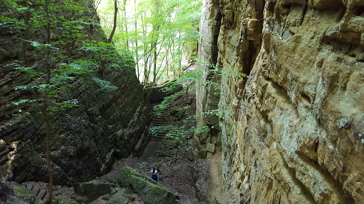
It isn’t technical, but it isn’t a stroll either. Expect narrow passages, steps, tree roots and dark sections like the Kuelscheier, the Rittergang and the Déiwepëtz; the site asks you to carry a torch and warns that the last two can’t be bypassed. Between Moersdorf and Echternach, through the Haard woods, there are no villages at all, so take water and food.
One thing few walkers think about is hunting. In season, the trail website suggests looking up hunting zones on geoportail.lu before you set off. As for waymarking, follow the red M, which marks the trail throughout.
You don’t need to buy a map. Every route and ExtraTour has a page on mullerthal-trail.lu with an interactive map, an elevation profile and two buttons to download the track as GPX or KML, which is what I’d load onto my phone before leaving, in case there’s no signal among the rocks. The same site lists the local loops too, such as Berdorf’s B2, which isn’t part of the long trail and often gets mixed up with Route 2.
The label, Leading Quality Trails - Best of Europe, comes from the European Ramblers Association, which judges variety of scenery, waymarking and public transport access. You notice it in how well signed everything is. For the bigger picture of the area, start with the guide to the Mullerthal region.
If you would rather have a local show you round, book a guided tour in Echternach and choose by the reviews.
A car frees you from timetables: search car hire in Luxembourg on DiscoverCars and compare companies.
So you do not pay over the odds, look at trains, coaches and flights to Luxembourg on Omio and pick the one that suits you.
The Wolfsschlucht, or Wolf's Gorge, near Echternach, a narrow passage between tall mossy sandstone walls
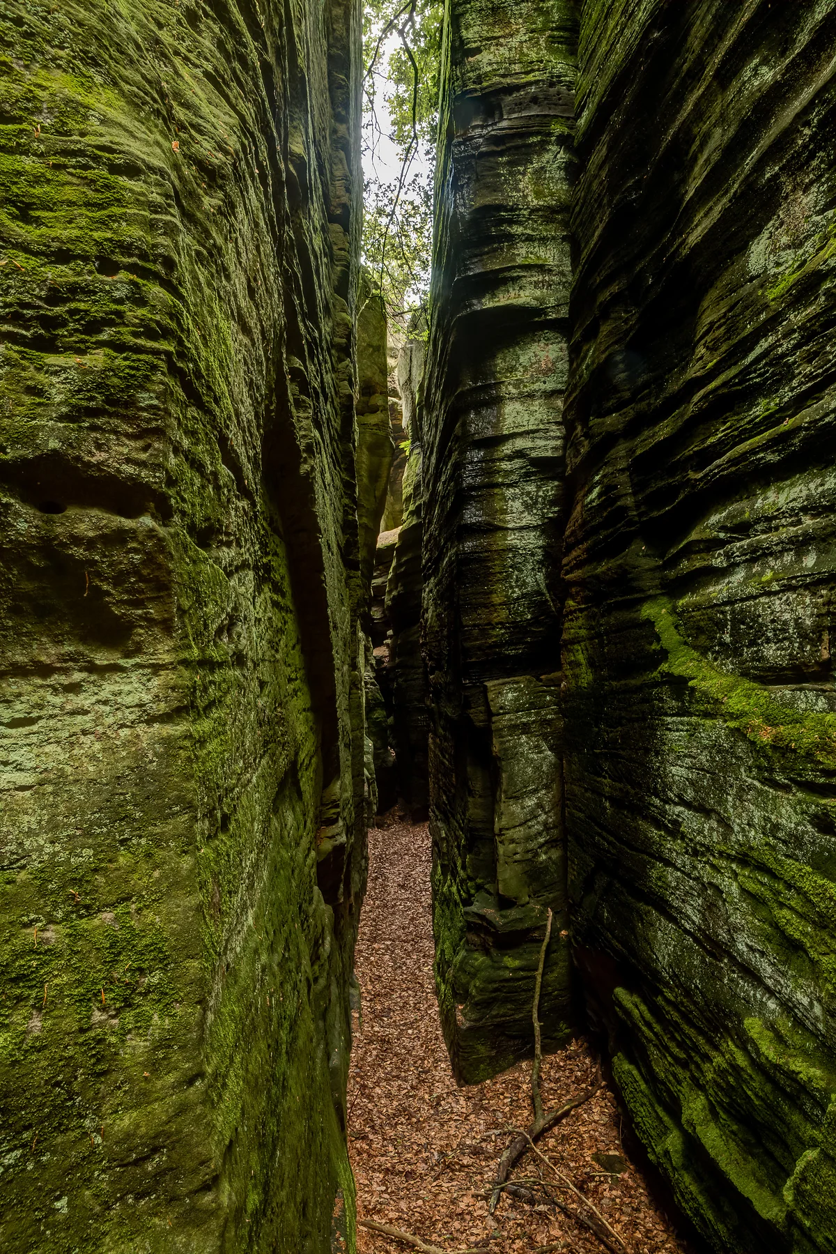
A tight passage between two moss-covered rock walls in the Werschrummschlëff labyrinth at Berdorf
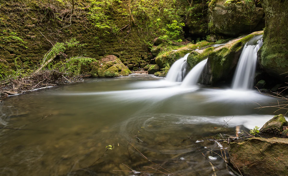
The Schiessentümpel waterfall on the Black Ernz, with water tumbling between mossy rocks and ferns
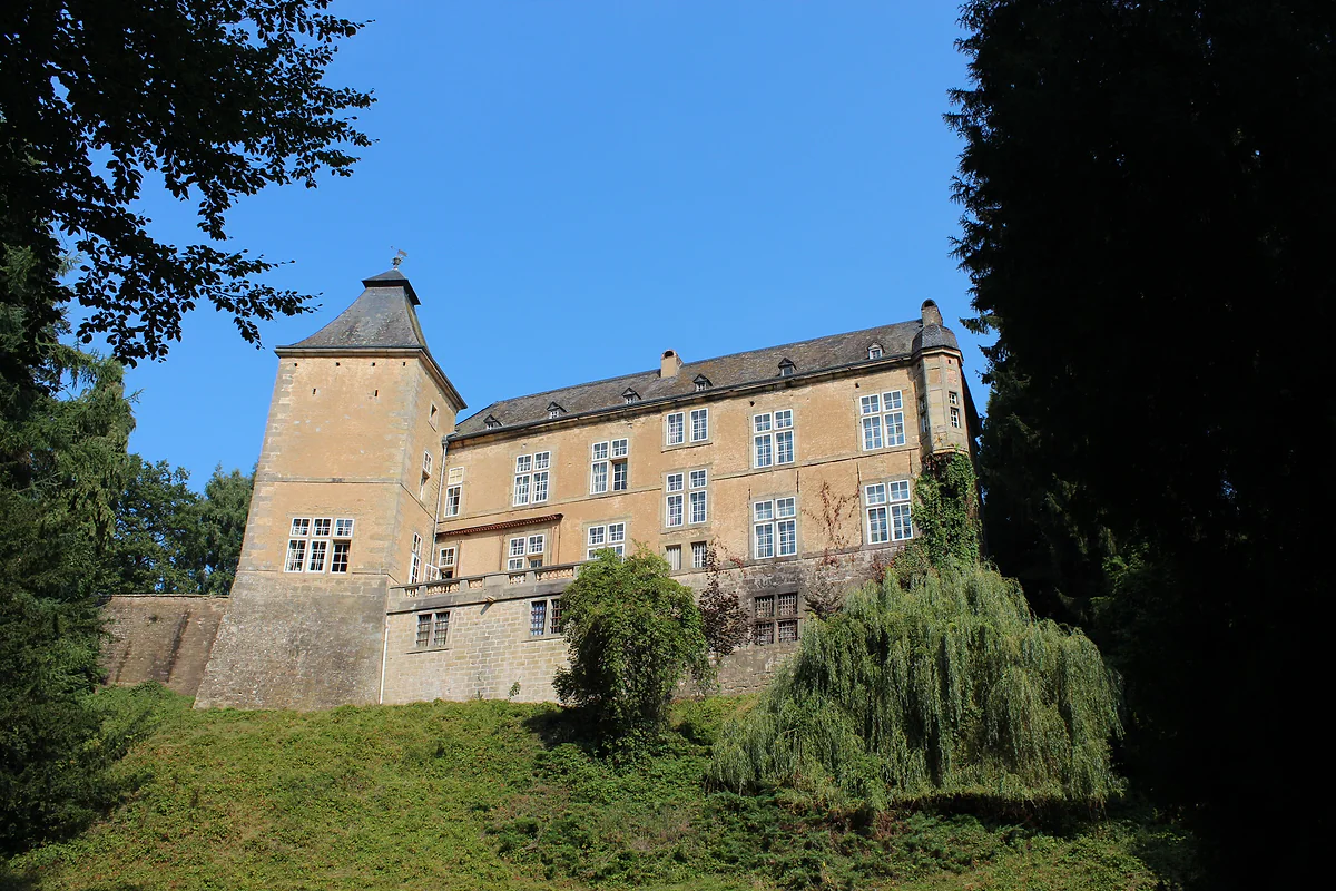
The 17th-century Renaissance castle at Beaufort, with a corner tower and pale façade above a grassy slope
The three Mullerthal Trail routes
| Route | Via | Distance | Walking time | Highest point |
|---|---|---|---|---|
| Route 1 | Echternach, Rosport, Moersdorf, Herborn | 36.7 km | 10 h 25 | 390 m |
| Route 2 | Echternach, Berdorf, Müllerthal, Hersberg, Scheidgen | 39.7 km | 12 h 50 | 387 m |
| Route 3 | Müllerthal, Blumenthal, Larochette, Beaufort | 37.7 km | 11 h 05 | 420 m |
Route sheets on mullerthal-trail.lu, checked on 29-09-2026. The government portal rounds them to 36, 38 and 38 km.
The ExtraTours
| ExtraTour | Distance |
|---|---|
| A | 22.8 km |
| B | 13 km |
| C | 9.3 km |
| D | 31.5 km |
| E | 25.5 km |
Operator's variants (mullerthal-trail.lu). The government portal describes four shorter, easier ExtraTours.
Test yourself
True or false?
0/3 Pick before you peek.
-
All three Mullerthal Trail routes start in Echternach.
See the answer
False. Routes 1 and 2 do. Route 3 starts in the hamlet of Müllerthal, where it joins Route 2.
-
Route 2 is the longest of the three.
See the answer
True. It's 39.7 km with an estimated 12 h 50 of walking, against 36.7 km for Route 1 and 37.7 km for Route 3.
-
The trail is waymarked with a red M.
See the answer
True. The official stage notes tell you to follow the red M, for instance when leaving Herborn for the Haard forest.
- Approximate total length
- 112 km
- Circular routes
- 3
- Stages in the operator's plan
- 6
- Highest point, on Route 3
- 420 m
0 of 425 Luxembourg guides
Your next stamp
- Mullerthal
- Hiking
- Beaufort
- Berdorf
- Mullerthal hotels
- Junglinster
- Hotels in Echternach
- A Possen Museum
- American Cemetery
- Ansembourg
- Ansembourg Castles
- Asselborn
- Bascharage
- Beaufort castles
- Belval
- Belval blast furnaces
- Berg Castle
- Bernard-Massard cellars
- Bourglinster Castle
- Bourscheid Castle
- Brandenbourg
- Brandenbourg Castle
- Caves St Martin
- Christmas
- Clervaux Castle
- Echternach
- Echternach Abbey
- Ehnen
- Ehnen Wine Museum
- Esch-sur-Alzette
- Esch-sur-Sûre Castle
- European Museum Schengen
- Fond-de-Gras
- General Patton Museum
- German war cemetery
- Haff Réimech
- Hohllay
- Hollenfels Castle
- Hosingen
- Kautenbach
- Kneiff
- Koerich Castle
- Larochette Castle
- Lasauvage
- Mersch Castle
- Military History Museum
- Moersdorf
- Mondorf Domaine Thermal
- Munsbach Castle
- National Mining Museum
- Parc Merveilleux
- Park Sënnesräich
- Places to visit
- Remich
- Rindschleiden
- Schiessentümpel
- Septfontaines Castle
- Slate Museum
- Stolzembourg
- Tudor Museum
- Useldange Castle
- Valley of the Seven Castles
- Vianden
- Vianden Castle
- Ville Haute
- Wasserbillig Aquarium
- Weiswampach lakes
- Wiltz Castle
- Ahn
- Bourscheid-Plage
- Butterfly garden
- Clervaux
- Differdange
- Echternach lake
- Grevenmacher
- Heringer Millen
- Hollenfels
- Luxembourg City
- Luxembourg Science Center
- Meysembourg Castle
- National Day
- National Resistance Museum
- Perekop
- Remerschen
- Schoenfels Castle
- The Family of Man
- Things to do
- Upper Sûre Lake
- Vianden chairlift
- Wasserbillig
- Clervaux Abbey
- Echternach Roman villa
- Éislek
- Insenborn
- Kallektuffquell
- Machtum
- Most beautiful places
- Our Nature Park
- Pétange
- Pettingen Castle
- Schueberfouer
- Schwebsingen
- Victor Hugo House
- Waldbillig
- Dudelange
- Kuelscheier
- Lultzhausen
- Moselle Valley
- Octave
- Prettiest villages
- Sanem
- Schengen
- Wellenstein
- Wiltz
- Wolfsschlucht
- Bech-Kleinmacher
- Éimaischen
- Gaalgebierg
- Guttland
- Marnach
- Mondorf-les-Bains
- Putscheid
- Schifflange
- UNESCO World Heritage
- Carnival
- Consdorf
- Ellergronn
- Käerjeng
- Kayl
- Map
- Minett
- Munshausen
- Tandel
- Bech
- Buergbrennen
- Esch-sur-Sûre
- Rumelange
- Where is Luxembourg
- Is it a country?
- Lac de la Haute-Sûre (commune)
- Rosport-Mompach
- Wormeldange
- Larochette
- Mondercange
- Regions
- Bettembourg
- Bock Casemates
- Cantons
- Dancing procession
- Diekirch
- Fischbach
- Garnich
- Mersch
- Moselle wine route
- Ettelbruck
- Grund
- Heffingen
- Kehlen
- Lintgen
- Moselle river cruises
- Pétrusse Casemates
- Towns and villages
- Chemin de la Corniche
- Erpeldange-sur-Sûre
- Kopstal
- Lorentzweiler
- Nommern
- Pfaffenthal
- Population
- Bissen
- Clausen
- Grand Ducal Palace
- Koerich
- Schieren
- Size
- Vallée de l'Ernz
- Feulen
- Kirchberg
- Languages
- Notre-Dame Cathedral
- Reisdorf
- Steinfort
- Bettendorf
- Habscht
- St Michael's Church
- Helperknapp
- Luxembourgish
- Place Guillaume II
- Name
- Place d'Armes
- History
- Place de la Constitution
- Grand Duke
- Colmar-Berg
- Flaxweiler
- Gare
- Hamm
- Kirchberg funicular
- Luxembourg fortress
- Mamer
- Mertert
- Minett Trail
- Neumünster Abbey
- Parc Hosingen
- Pfaffenthal lift
- Political system
- Redange
- The Passerelle
- Wine festivals
- Winseler
- Beckerich
- Biwer
- EU institutions
- Goesdorf
- Limpertsberg
- Mudam
- Natur Musée
- Pulvermühl
- Stadtbredimus
- Troisvierges
- Wenzel walk
- Bonnevoie
- Bous-Waldbredimus
- Ell
- Flag
- Kiischpelt
- Manternach
- Philharmonie
- Vauban circuit
- Weiswampach
- Betzdorf
- Boulaide
- Dräi Eechelen Museum
- Facts
- Hollerich
- Lenningen
- Useldange
- Wincrange
- Bourscheid
- Dalheim
- Gasperich
- Public holidays
- Red Bridge
- Saeul
- Belair
- Second World War
- Vichten
- Battle of the Bulge
- Merl
- Préizerdaul
- Cents
- EU and Schengen
- Groussbus-Wal
- Entry requirements
- Neudorf
- Rambrouch
- Currency and payments
- Mertzig
- Weimerskirch
- Adolphe Bridge
- Beggen
- Escapardenne
- How to get there
- International March of Diekirch
- MNHA (National Museum)
- Rock climbing
- Sandweiler
- Bridges
- Eich
- Flights
- Golf
- Hesperange
- Lëtzebuerg City Museum
- Canoeing and kayaking
- Dommeldange
- Luxembourg airport
- Strassen
- Villa Vauban
- Airport to city centre
- Bertrange
- Casino Luxembourg
- Mühlenbach
- Swimming pools
- From Brussels
- Pétrusse Valley
- Rollingergrund
- Walferdange
- Cessange
- Day trip from Brussels
- Municipal Park
- Steinsel
- Free walking tours
- From Paris
- Niederanven
- From Frankfurt
- Schuttrange
- Sightseeing train and bus
- By train
- Contern
- By coach
- Weiler-la-Tour
- Driving
- Luxembourg in one day
- Pretzel Sunday
- Rham Plateau
- Tour de Luxembourg
- Candlemas (Liichtmëssdag)
- Car hire
- Luxembourg in two days
- Saint-Esprit Plateau
- Luxembourg in three days
- Melusina statue
- Parking
- St Nicholas Day (Kleeschen)
- Fête de la Musique
- Luxembourg in four days
- Museums in Luxembourg
- Petrol
- Place de Clairefontaine
- A week in Luxembourg
- Getting around
- Luxembourg Marathon
- Tram and Bus Museum
- Free public transport
- Parks in Luxembourg City
- Road trip
- Belgium and Luxembourg
- Tram
- Buses
- Viewpoints
- Trains
- Luxembourg station
- Cycling
- LuxembourgPass
- Prices and budget
- On a budget
- Free things to do
- Mobile and roaming
- Healthcare
- Safety
- Scams
- Tourist information
- Packing list
- Swimming lakes
- With a dog
- Markets
- Tipping
- Shopping
- What to buy
- Shopping centres
- With kids
- For couples
- Playgrounds
- Adventure parks
- Nightlife
- Castles
- Theatres and concert venues
- Leudelange
- Nature parks
- Where to stay
- City-centre hotels
- Nature reserves
- Reckange-sur-Mess
- Hotels near the station
- Roeser
- Frisange
- Hotels in Kirchberg
- Airport hotels
- Dippach
- Hotels in Vianden
- Hotels in Clervaux
- Hotels in Mondorf-les-Bains
- Hotels in Esch-sur-Alzette
- Hotels on the Moselle
- Upper Sûre lake hotels
- Hotels in Diekirch and Ettelbruck
- Cheap hotels
- Luxury hotels
- Boutique hotels
- Spa hotels
- Family hotels
- Apartments
- Weather
- Youth hostels
- Best time to visit
- Campsites
- Holiday cottages
- In winter
- Castle hotels
- In spring
- Day trips
- In summer
- Around Luxembourg
- In autumn
- Ice skating
- Trier day trip
- Metz day trip
- Arlon day trip
- In January
- In February
- In March
- In April
- In May
- In June
- In July
- In August
- In September
- Food
- In October
- In November
- Where to eat
- In December
- Michelin restaurants
- Cheap eats
- Judd mat Gaardebounen
- Bouneschlupp
- Gromperekichelcher
- Kniddelen
- Quetschentaart
- Rieslingspaschtéit
- Events
- Wine
- Crémant
- Beer
Frequently asked questions
How long is the Mullerthal Trail?
About 112 km in three circular routes. The operator's route sheets give 36.7 km for Route 1, 39.7 km for Route 2 and 37.7 km for Route 3.
Which Mullerthal Trail route is best?
For me it's Route 2, the rock route, with the Wolfsschlucht, the Perekop, the Hohllay, the Schiessentümpel and the Kuelscheier. Route 3 is the castles route via Beaufort and Larochette, and Route 1 is the quietest, along the Sûre.
How many days do you need for the Mullerthal Trail?
The operator suggests six stages of 13.2 to 25.3 km, one a day, starting and finishing in Echternach. You can also walk any single route over two days.
Where does the Mullerthal Trail start?
Routes 1 and 2 start at the basilica in Echternach, Route 3 at the Heringer Millen in the hamlet of Müllerthal. As they're loops, you can join at any village along the way.
Can you do the Mullerthal Trail by public transport?
Yes, and it's free. The trail website gives the direct 201, or the 211 and 212, from Kirchberg Luxexpo to Echternach every half hour. Check the day's times on mobiliteit.lu.
Is the Mullerthal Trail hard?
There are no big climbs, as the highest points sit between 387 and 420 m, but you'll meet narrow rock passages, ladders, steps and dark clefts. Walking boots and reasonable fitness are enough.
Where can I download the Mullerthal Trail map or GPX?
On the official site, mullerthal-trail.lu. Each route and ExtraTour has its own page with an interactive map, an elevation profile and free downloads of the track as GPX or KML. I'd save it before setting off, because signal drops out among the rocks.
What is B2 in the Mullerthal?
It's a local trail in Berdorf, not one of the Mullerthal Trail routes. Its official page gives 4.3 km and 1 h 35, starting from the Berdorf tourist office and taking in the Ruetsbech gorge, an optional iron ladder in the Raiberhiel and the Siweschlëff, in the Wanterbaach climbing area.
By
Tourism graduate with a master’s in Tourism Management and Planning from the University of Málaga, who has travelled across Europe. He writes every guide from official sources and his own judgement.
Published on . Updated on . Facts checked on .
Sources
Some links in this guide are affiliate links: if you book through them, the site earns a commission at no extra cost to you. Affiliate disclosure
Photos: GilPe (CC BY-SA 4.0); Steffen 962 (CC BY-SA 4.0); Dietmar Rabich (CC BY-SA 4.0); Dietmar Rabich (CC BY-SA 4.0); Zinneke (CC BY-SA 3.0 lu), via Wikimedia Commons.