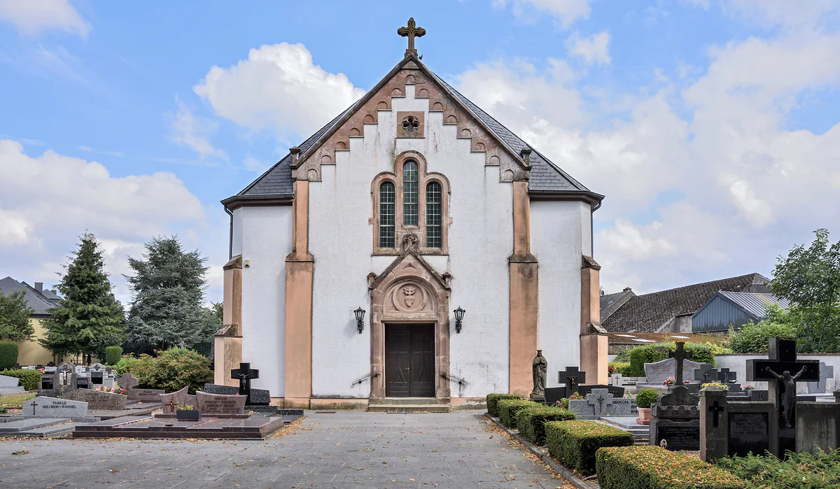
Canton of Wiltz, population 1,579
Boulaide, three villages at the western edge between the Sûre and the lake
Boulaide is the commune at Luxembourg's western edge, at the head of the Upper Sûre lake, with 1,579 residents on 1 January 2026 in three villages, Boulaide, Baschleiden and Surré. It has two viewpoints over the river and the lake, the Houfëls and the Tempelskamp, and a free exhibition on life in the cross-border Greater Region.
In 30 seconds
Full read: 2 min
- Boulaide has 1,579 residents in Boulaide, Baschleiden and Surré.
- Luxembourg's westernmost point lies within the commune.
- The Houfëls and Tempelskamp viewpoints look over the Sûre and the lake.
- Our Common Heritage is a free exhibition outside the town hall.
Boulaide makes a good end to a drive up the Upper Sûre lake from the east. I'd go to the Houfëls late in the day, walk down to the Tempelskamp if my legs allow, and keep the exhibition for a rainy day, since it's free and indoors.
Before you go
What I would keep in mind
-
01 Most beautiful
The Houfëls, 140 metres above the Sûre
From the Houfëls rock, at 463 m according to the commune, you look down on the Sûre meanders about 140 metres below and on the old Bigonville mill across the border in Belgium. Reachable on foot or by car.
-
02 To save money
A free exhibition by the town hall
Our Common Heritage covers life in the border lands of the Greater Region from the Belle Époque to a united Europe. It's free and opens Monday to Friday 10:00-17:00 and weekends until 18:00.
-
03 My tip
The Tempelskamp at first light
Near Baschleiden, a 6-metre tower overlooks the Upper Sûre lake and the Rommwiss. It's walk-in only, and visitluxembourg recommends early morning, with mist lying on the water.
Upper Sûre lake
Boulaide is where the map runs out. According to STATEC, Luxembourg’s westernmost point lies within it, and the commune lives between the Belgian border and the head of the Upper Sûre lake. It had 1,579 residents on 1 January 2026, and the commune splits them across three villages, Boulaide with 802, Baschleiden with 518 and Surré with 259. In Luxembourgish, Boulaide is Bauschelt.
The Houfëls and the story of a hotel
The Houfëls viewpoint sits on a rise south of Boulaide, at 463 metres according to the commune. From the rock you see the Sûre meanders about 140 metres below, the old Bigonville mill and the village of Bilsdorf. You reach it along a track off the CR310 towards Bigonville or on several footpaths.
There’s a story behind it that I enjoy. Around 1830 the Hames family opened a shop in Boulaide that grew into a hotel, and between the wars their son-in-law Jean Winandy hosted steel magnates such as Emile Mayrisch and aristocrats who came to hunt and fish. In 1935-36 he built a thatched chalet on the Houfëls, and in 1935 the local tourist association was founded, with Winandy as chairman until 1971. The chalet was restored in 2013. Beside it stand two Second World War artillery pieces.
The Tempelskamp and the Rommwiss
Near Baschleiden, a 6-metre tower looks out over the lake and the Rommwiss, the bathing lawn on this shore, plus woods and rocky outcrops. It’s walk-in only, on the 8.55 km Auto-Pédestre Baschleiden or the Circuit du Lac on its western side. visitluxembourg suggests going early, with mist on the water, or at sunset.
The Rommwiss is one of the six monitored swimming spots on the Upper Sûre lake. On 28 September 2026 swimming there was banned because of cyanobacteria, and in any case the official season ends on 30 September.
Once your dates are set, check which hotels are still free in Esch-sur-Sûre before prices climb.
An exhibition about the border
Outside the town hall, in a converted container, Our Common Heritage traces life in the Greater Region, the border area shared by Belgium, Luxembourg, Germany and France, from the Belle Époque to the birth of Europe. It uses giant photo albums and an immersive sound-and-image section. For visitors from a country with only one land border, it’s an interesting look at how porous borders shape everyday life. It’s free and opens Monday to Friday 10:00-17:00 and Saturday and Sunday 10:00-18:00.
Walking from the village
The Auto-Pédestre Boulaide, 9.26 km and about 2 hours 50 minutes, leaves the centre along the Bällerbaach to the Bauschelter Millen, a 14th-century mill still lived in, crosses the Sûre twice and climbs to the Houfëls. If you want more, neighbouring Lac de la Haute-Sûre has further viewpoints and a wartime bunker.
Once your dates are set, check which hotels are still free in Esch-sur-Sûre before prices climb.
A bed for the night
There’s no STATEC hotel count for Boulaide. The practical base is Esch-sur-Sûre, with hotels, holiday flats and campsites around the lake.
If you would rather have a local show you round, book a guided tour in Esch-sur-Sûre and choose by the reviews.
A car frees you from timetables: search car hire in Luxembourg on DiscoverCars and compare companies.
So you do not pay over the odds, look at trains, coaches and flights to Luxembourg on Omio and pick the one that suits you.
Boulaide's three villages
| Village | Residents | Share of the commune |
|---|---|---|
| Boulaide | 802 | 50.79% |
| Baschleiden | 518 | 32.81% |
| Surré | 259 | 16.40% |
Boulaide commune website, checked on 30 September 2026. The total matches STATEC's 1,579 on 1 January 2026.
What to see in Boulaide
| Sight | Where | Practical note |
|---|---|---|
| Houfëls viewpoint | South of Boulaide | Farm track off the CR310, or on foot |
| Tempelskamp viewpoint | Near Baschleiden | 6 m tower, walk-in only |
| Our Common Heritage | 3 rue de la Mairie | Free; Mon-Fri 10-17, Sat-Sun 10-18 |
| Auto-Pédestre Boulaide | Starts on rue du Curé | 9.26 km, 2h50 |
| Auto-Pédestre Baschleiden | Starts on Rue Principale | 8.55 km, 2h40 |
Test yourself
True or false?
0/3 Pick before you peek.
-
Luxembourg's westernmost point is in the Boulaide commune.
See the answer
True. STATEC places it at 5° 44' 10" east, in Boulaide. The easternmost point is in Rosport.
-
Tourism in Boulaide took off with the Upper Sûre dam.
See the answer
True. The commune says there were hunting and fishing visitors before the war, but the real boom came with the Esch-sur-Sûre dam and its lake.
-
Our Common Heritage costs €10 per adult.
See the answer
False. It's free. It's set up in a converted container outside the town hall.
- Residents on 1 January 2026
- 1,579
- Houfëls altitude, per the commune
- 463 m
- Local tourist association founded
- 1935
- Entry to Our Common Heritage
- €0
Map
Where Boulaide is
The thick dashed line is the border with Belgium, France and Germany, and the fine ones divide the twelve cantons. The Éislek lies to the north and the Moselle to the east. Every number opens its guide.
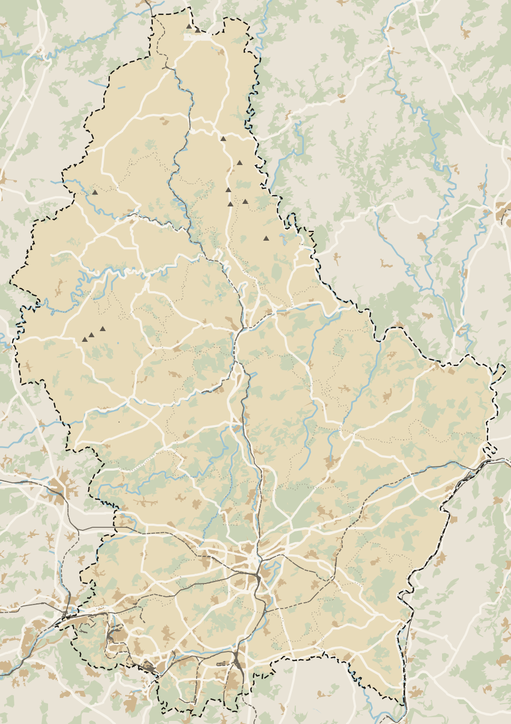 1Vianden 2Clervaux 3Wiltz 4Putscheid 5Tandel 6Esch-sur-Sûre 7Lac de la Haute-Sûre (commune) 8Diekirch 9Ettelbruck 10Erpeldange-sur-Sûre 11Schieren 12Feulen 13Bettendorf 14Colmar-Berg 15Parc Hosingen 16Winseler 17Goesdorf 18Troisvierges 19Kiischpelt 20Weiswampach 21Boulaide 22Wincrange 23Bourscheid
 Map data © OpenStreetMap contributors (ODbL)
- 1ViandenCanton of Vianden, on the River Our
- 2ClervauxCommune of 6,327 people, canton of Clervaux
- 3WiltzCanton of Wiltz, population 8,538
- 4PutscheidCanton of Vianden, 27.13 km²
- 5TandelCanton of Vianden, 11 localities
- 6Esch-sur-SûreCanton of Wiltz, commune population 3,373
- 7Lac de la Haute-Sûre (commune)Canton of Wiltz, population 2,320
- 8DiekirchCanton of Diekirch, the Nordstad
- 9EttelbruckCanton of Diekirch, heart of the Nordstad
- 10Erpeldange-sur-SûreCanton of Diekirch, next to Ettelbruck
- 11SchierenCanton of Diekirch, 3 localities
- 12FeulenCanton of Diekirch, Niederfeulen and Oberfeulen
- 13BettendorfCanton of Diekirch, Bettendorf, Gilsdorf and Moestroff
- 14Colmar-BergCanton of Mersch, 2 localities
- 15Parc HosingenCanton of Clervaux, 272 to 517 m
- 16WinselerCanton of Wiltz, population 1,590
- 17GoesdorfCanton of Wiltz, population 1,682
- 18TroisviergesCanton of Clervaux, the country's far north
- 19KiischpeltCanton of Wiltz, population 1,309
- 20WeiswampachCanton of Clervaux, on the Belgian border
- 21BoulaideCanton of Wiltz, population 1,579
- 22WincrangeCanton of Clervaux, 113.36 km²
- 23BourscheidCanton of Diekirch, 206 to 513 m
0 of 425 Luxembourg guides
Your next stamp
- Lac de la Haute-Sûre (commune)
- Bourscheid-Plage
- Wasserbillig
- Troisvierges
- Mertert
- Bourscheid
- Rambrouch
- Viewpoints
- A Possen Museum
- American Cemetery
- Ansembourg
- Ansembourg Castles
- Asselborn
- Bascharage
- Beaufort castles
- Belval
- Belval blast furnaces
- Berg Castle
- Bernard-Massard cellars
- Bourglinster Castle
- Bourscheid Castle
- Brandenbourg
- Brandenbourg Castle
- Caves St Martin
- Christmas
- Clervaux Castle
- Echternach
- Echternach Abbey
- Ehnen
- Ehnen Wine Museum
- Esch-sur-Alzette
- Esch-sur-Sûre Castle
- European Museum Schengen
- Fond-de-Gras
- General Patton Museum
- German war cemetery
- Haff Réimech
- Hohllay
- Hollenfels Castle
- Hosingen
- Kautenbach
- Kneiff
- Koerich Castle
- Larochette Castle
- Lasauvage
- Mersch Castle
- Military History Museum
- Moersdorf
- Mondorf Domaine Thermal
- Munsbach Castle
- National Mining Museum
- Parc Merveilleux
- Park Sënnesräich
- Places to visit
- Remich
- Rindschleiden
- Schiessentümpel
- Septfontaines Castle
- Slate Museum
- Stolzembourg
- Tudor Museum
- Useldange Castle
- Valley of the Seven Castles
- Vianden
- Vianden Castle
- Ville Haute
- Wasserbillig Aquarium
- Weiswampach lakes
- Wiltz Castle
- Ahn
- Berdorf
- Butterfly garden
- Clervaux
- Differdange
- Echternach lake
- Grevenmacher
- Heringer Millen
- Hollenfels
- Luxembourg City
- Luxembourg Science Center
- Meysembourg Castle
- Mullerthal
- National Day
- National Resistance Museum
- Perekop
- Remerschen
- Schoenfels Castle
- The Family of Man
- Things to do
- Upper Sûre Lake
- Vianden chairlift
- Clervaux Abbey
- Echternach Roman villa
- Éislek
- Insenborn
- Kallektuffquell
- Machtum
- Most beautiful places
- Our Nature Park
- Pétange
- Pettingen Castle
- Schueberfouer
- Schwebsingen
- Victor Hugo House
- Waldbillig
- Dudelange
- Kuelscheier
- Lultzhausen
- Moselle Valley
- Octave
- Prettiest villages
- Sanem
- Schengen
- Wellenstein
- Wiltz
- Wolfsschlucht
- Beaufort
- Bech-Kleinmacher
- Éimaischen
- Gaalgebierg
- Guttland
- Marnach
- Mondorf-les-Bains
- Putscheid
- Schifflange
- UNESCO World Heritage
- Carnival
- Consdorf
- Ellergronn
- Käerjeng
- Kayl
- Map
- Minett
- Munshausen
- Tandel
- Bech
- Buergbrennen
- Esch-sur-Sûre
- Rumelange
- Where is Luxembourg
- Is it a country?
- Rosport-Mompach
- Wormeldange
- Larochette
- Mondercange
- Regions
- Bettembourg
- Bock Casemates
- Cantons
- Dancing procession
- Diekirch
- Fischbach
- Garnich
- Mersch
- Moselle wine route
- Ettelbruck
- Grund
- Heffingen
- Kehlen
- Lintgen
- Moselle river cruises
- Pétrusse Casemates
- Towns and villages
- Chemin de la Corniche
- Erpeldange-sur-Sûre
- Junglinster
- Kopstal
- Lorentzweiler
- Nommern
- Pfaffenthal
- Population
- Bissen
- Clausen
- Grand Ducal Palace
- Koerich
- Schieren
- Size
- Vallée de l'Ernz
- Feulen
- Kirchberg
- Languages
- Notre-Dame Cathedral
- Reisdorf
- Steinfort
- Bettendorf
- Habscht
- St Michael's Church
- Helperknapp
- Luxembourgish
- Place Guillaume II
- Name
- Place d'Armes
- History
- Place de la Constitution
- Grand Duke
- Colmar-Berg
- Flaxweiler
- Gare
- Hamm
- Kirchberg funicular
- Luxembourg fortress
- Mamer
- Minett Trail
- Mullerthal Trail
- Neumünster Abbey
- Parc Hosingen
- Pfaffenthal lift
- Political system
- Redange
- The Passerelle
- Wine festivals
- Winseler
- Beckerich
- Biwer
- EU institutions
- Goesdorf
- Limpertsberg
- Mudam
- Natur Musée
- Pulvermühl
- Stadtbredimus
- Wenzel walk
- Bonnevoie
- Bous-Waldbredimus
- Ell
- Flag
- Kiischpelt
- Manternach
- Philharmonie
- Vauban circuit
- Weiswampach
- Betzdorf
- Dräi Eechelen Museum
- Facts
- Hollerich
- Lenningen
- Useldange
- Wincrange
- Dalheim
- Gasperich
- Public holidays
- Red Bridge
- Saeul
- Belair
- Second World War
- Vichten
- Battle of the Bulge
- Merl
- Préizerdaul
- Cents
- EU and Schengen
- Groussbus-Wal
- Entry requirements
- Neudorf
- Currency and payments
- Mertzig
- Weimerskirch
- Adolphe Bridge
- Beggen
- Escapardenne
- How to get there
- International March of Diekirch
- MNHA (National Museum)
- Rock climbing
- Sandweiler
- Bridges
- Eich
- Flights
- Golf
- Hesperange
- Lëtzebuerg City Museum
- Canoeing and kayaking
- Dommeldange
- Luxembourg airport
- Strassen
- Villa Vauban
- Airport to city centre
- Bertrange
- Casino Luxembourg
- Mühlenbach
- Swimming pools
- From Brussels
- Pétrusse Valley
- Rollingergrund
- Walferdange
- Cessange
- Day trip from Brussels
- Municipal Park
- Steinsel
- Free walking tours
- From Paris
- Niederanven
- From Frankfurt
- Schuttrange
- Sightseeing train and bus
- By train
- Contern
- By coach
- Weiler-la-Tour
- Driving
- Luxembourg in one day
- Pretzel Sunday
- Rham Plateau
- Tour de Luxembourg
- Candlemas (Liichtmëssdag)
- Car hire
- Luxembourg in two days
- Saint-Esprit Plateau
- Luxembourg in three days
- Melusina statue
- Parking
- St Nicholas Day (Kleeschen)
- Fête de la Musique
- Luxembourg in four days
- Museums in Luxembourg
- Petrol
- Place de Clairefontaine
- A week in Luxembourg
- Getting around
- Luxembourg Marathon
- Tram and Bus Museum
- Free public transport
- Parks in Luxembourg City
- Road trip
- Belgium and Luxembourg
- Tram
- Buses
- Trains
- Luxembourg station
- Cycling
- LuxembourgPass
- Prices and budget
- On a budget
- Free things to do
- Mobile and roaming
- Healthcare
- Safety
- Scams
- Tourist information
- Packing list
- Swimming lakes
- With a dog
- Markets
- Tipping
- Shopping
- What to buy
- Shopping centres
- With kids
- For couples
- Playgrounds
- Adventure parks
- Nightlife
- Castles
- Theatres and concert venues
- Leudelange
- Nature parks
- Where to stay
- City-centre hotels
- Hiking
- Nature reserves
- Reckange-sur-Mess
- Hotels near the station
- Roeser
- Frisange
- Hotels in Kirchberg
- Airport hotels
- Dippach
- Hotels in Vianden
- Hotels in Echternach
- Hotels in Clervaux
- Hotels in Mondorf-les-Bains
- Hotels in Esch-sur-Alzette
- Hotels on the Moselle
- Mullerthal hotels
- Upper Sûre lake hotels
- Hotels in Diekirch and Ettelbruck
- Cheap hotels
- Luxury hotels
- Boutique hotels
- Spa hotels
- Family hotels
- Apartments
- Weather
- Youth hostels
- Best time to visit
- Campsites
- Holiday cottages
- In winter
- Castle hotels
- In spring
- Day trips
- In summer
- Around Luxembourg
- In autumn
- Ice skating
- Trier day trip
- Metz day trip
- Arlon day trip
- In January
- In February
- In March
- In April
- In May
- In June
- In July
- In August
- In September
- Food
- In October
- In November
- Where to eat
- In December
- Michelin restaurants
- Cheap eats
- Judd mat Gaardebounen
- Bouneschlupp
- Gromperekichelcher
- Kniddelen
- Quetschentaart
- Rieslingspaschtéit
- Events
- Wine
- Crémant
- Beer
Frequently asked questions
Where is Boulaide?
In the west of the canton of Wiltz, on the Belgian border at the head of the Upper Sûre lake. Luxembourg's westernmost point, at 5° 44' 10" east, lies within the commune.
What is there to do in Boulaide?
Take in the Houfëls viewpoint over the Sûre meanders and the Tempelskamp over the lake, see the free Our Common Heritage exhibition and walk one of two Auto-Pédestre loops of just over 8 and 9 km.
What is Our Common Heritage?
An exhibition about life in the border territories of the Greater Region, from the Belle Époque to the founding of Europe, with giant photo albums and an immersive section in a converted container. It stands outside the town hall and is free.
Can you swim near Boulaide?
The nearest bathing area is the Rommwiss at Baschleiden, one of six on the Upper Sûre lake monitored by the Water Management Authority. On 28 September 2026 swimming there was banned because of cyanobacteria, and the season ends on 30 September.
Where can I stay near Boulaide?
STATEC doesn't publish hotel numbers for Boulaide. The nearest base with hotels, holiday flats and campsites is Esch-sur-Sûre, at the other end of the lake.
By
Tourism graduate with a master’s in Tourism Management and Planning from the University of Málaga, who has travelled across Europe. He writes every guide from official sources and his own judgement.
Published on . Facts checked on .
Sources
Some links in this guide are affiliate links: if you book through them, the site earns a commission at no extra cost to you. Affiliate disclosure
Photos: Cayambe (CC BY-SA 4.0), via Wikimedia Commons.