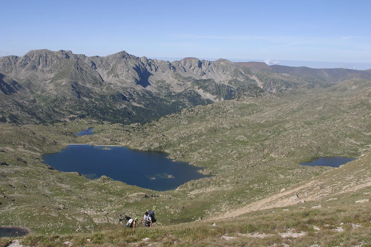
Head of the Madriu valley
Estany de l'Illa, the Madriu's great lake and its hut
The Estany de l'Illa is Andorra's second-largest lake, at the head of the Madriu valley, and takes its name from a small island. Beside its dam stands the staffed l'Illa mountain hut, at 2,488 m and open all year. The shortest route starts at Grau Roig, 8.66 km with 790 m of ascent, and is for experienced walkers.
In 30 seconds
Full read: 3 min
- The Estany de l'Illa is Andorra's second-largest lake, at the head of the Madriu valley.
- The staffed l'Illa hut stands by its dam at 2,488 m and opens all year.
- The shortest route starts at Grau Roig, 8.66 km with 790 m of ascent, for experienced walkers.
This isn't a lake for trainers on a random Saturday. I'd hike it from Grau Roig in high summer with a settled forecast and stay the night in the hut, so I could see the water at dawn with nobody else about.

Before you go
What I would keep in mind
-
01 Most beautiful
An island lake under dark skies
Andorra Turisme explains that the lake is named after its small island. The Coronallacs route sheet adds that with no light pollution, it's a good spot for stargazing.
-
02 Worth the splurge
A night in the staffed hut
The l'Illa hut sleeps about sixty, 50 in the staffed section and 10 in the free part, and opens all year. Bookings go through refugidelilla.ad.
mountain huts in Andorra -
03 My tip
Start at Grau Roig, not down in the valley
From the Cubil car park at Grau Roig it's 8.66 km and 790 m of ascent. From Les Pardines the climb is more than 1,300 m.
Grau Roig -
04 Getting there
Night one of the Coronallacs
The five-day loop round Andorra's staffed huts stops here on its first night, after 12.6 km from Escaldes through the Madriu.
Coronallacs trek
What I would book
The Estany de l’Illa is one of those places you earn. There’s no road or cable car, and even the shortest route asks for nearly 800 m of climbing and a mountain pass. In return you reach Andorra’s second-largest lake, at the head of the Madriu, with a staffed hut right on its shore. For me it’s the best night in the mountains you can spend in the country.
The country’s second lake
The official website of the Madriu valley lists the Estany de l’Illa as the second-largest lake in Andorra, behind only Juclar. Andorra Turisme says the name comes from the little island in the middle, which you see clearly as you look down from the Portella dels Pessons.
Part of what you see is man-made. The dam was built between 1947 and 1955 by seasonal workers who lodged in the old unstaffed hut, and its water partly feeds the national hydroelectric station. Other lakes lie close by, including the Bova, the Rodó, the Estany d’Encamp and the Forcat.
How do you hike to the Estany de l’Illa?
The shortest route leaves the Cubil car park at Grau Roig, next to a large glass-and-timber building. A path heads west to the first Pessons lake, and behind the restaurant a yellow-dot trail passes Lake Forcat and the Solana lakes. From the third Pessons lake you follow GRP and GR7 waymarks up a steep, winding slope to the Portella dels Pessons, where the lake comes into view. From there it’s downhill on the GR7. That’s 8.66 km, 790 m up and 392 m down, and Andorra Turisme grades it for experts.
The alternative starts at Les Pardines, at km 3 of the CS-220, and climbs the Agols valley before entering the Madriu. It’s 9.18 km but with more than 1,300 m of ascent, so I’d leave it to people who know the area. And from Escaldes, through the Madriu, it’s the first stage of the Coronallacs, 12.6 km and nearly 1,500 m of climbing.
The l’Illa hut
It stands at 2,488 m on the lakeshore, just below the dam, south of the Gargantillar ridges and the Pessons and Ríbuls peaks. It’s staffed and open all year, with about sixty places, 50 in the staffed section and 10 in the free part. Bookings go through refugidelilla.ad. It’s one of Andorra’s four staffed huts, with showers, beds and simple hot food, and the full list is in mountain huts in Andorra.
Staying the night lets you see the lake at sunset and sunrise, when the day walkers have gone. The Coronallacs route sheet notes that with no light pollution it’s a fine place to look at the stars, which makes sense.
Around the lake
If you stay the night, you’ll have half a day to wander without a rucksack. Close by are the Estany Rodó and the Bova lake, named after the bulrush that thrives in it, as well as the Encamp and Forcat lakes. The Coronallacs route sheet notes that the surrounding lakes draw anglers, which the Madriu permits with a licence. From the Pla de l’Ingla, a little lower down, you can see the Estall Serrer, the Port de Setut and the Pic de la Portelleta, the valley’s highest point at 2,905 m.
The Madriu’s buffer zone also has several unstaffed huts within a day’s outing, such as Ensagents, at 2,425 m between the Ensagents and Moreno lakes, or Montmalús, at 2,445 m on the shore of its own lake. On a clear evening, with no towns in sight, it’s the corner of Andorra that feels most remote to me.
Before you go
This is high mountain terrain. Officially, anything above 1,700 m is best left for the window from the close of June to the close of September, with May and October possible only when conditions allow. Carry enough food and water, wear proper boots and check the forecast. Your GHIC won’t help in Andorra, which sits outside the EU, and for a route graded for experts I’d make sure your travel insurance includes mountain rescue. If you’d prefer lakes with less commitment, the Pessons lakes offer shorter outings from the same car park, and they still give you a proper taste of Andorra’s glacial lakes.
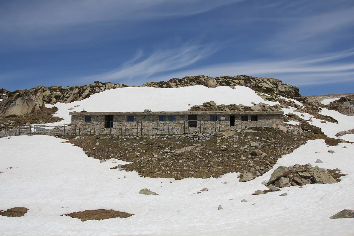
The Refugi de l'Illa at the head of the Madriu valley, its stone building surrounded by snow
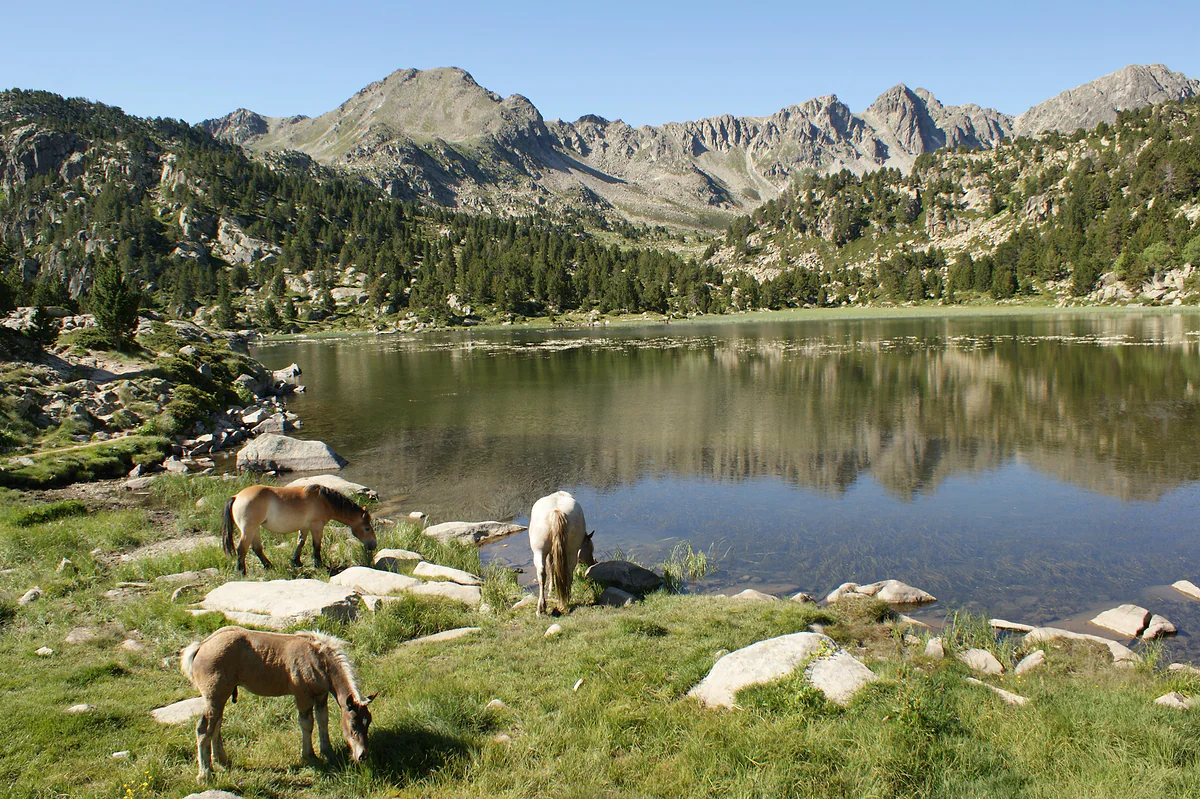
Horses grazing beside one of the Pessons lakes, with the peaks of the cirque reflected in the water
Routes to the Estany de l'Illa
| Start | Distance | Height gain | Grade | Via |
|---|---|---|---|---|
| Grau Roig, Cubil car park | 8.66 km | +790 m / −392 m | Experts only | Pessons lakes and Portella dels Pessons |
| Les Pardines, km 3 of the CS-220 | 9.18 km | +1,329 m / −275 m | Hard | Agols valley and the Madriu |
| Escaldes-Engordany (Coronallacs, stage 1) | 12.6 km | +1,473 m / −40 m | Moderate, about 6 h 38 | Tosca bridge, GR7, Ràmio, Fontverd |
Andorra Turisme route sheets, checked on 29-09-2026. Routes above 1,700 m are recommended from late June to late September.
Test yourself
True or false?
0/3 Pick before you peek.
-
The Estany de l'Illa is the largest lake in Andorra.
See the answer
False. It's the second-largest. The biggest is the first of the Juclar lakes, at 21 hectares.
-
The dam at the Estany de l'Illa was built in the mid-20th century.
See the answer
True. Andorra Turisme dates it to 1947-1955, built by workers who lodged in the hut.
-
The l'Illa hut only opens in summer.
See the answer
False. The valley's official site lists it as a staffed hut open all year.
Map
Where Estany de l'Illa is
The dashed line is the border with France and Spain. The Valira valley runs down from Pas de la Casa to Sant Julià, with Ordino and La Massana in the northern valley. Every number opens its guide.
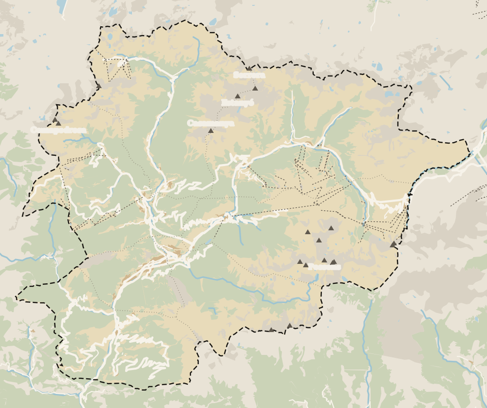
0 of 269 Andorra guides
Your next stamp
- Hiking
- Juclar lakes
- Pessons lakes
- Lakes
- GR11 and other GRs
- Coronallacs
- Engolasters lake
- Easy walks
- Places to visit
- Things to do
- Most beautiful places
- Prettiest villages
- Andorra la Vella
- UNESCO World Heritage
- Map
- Escaldes-Engordany
- Where is Andorra?
- Is Andorra a country?
- Parishes
- Casa de la Vall
- Margineda bridge
- Old town
- Santa Coloma church
- Towns and villages
- Population
- Size
- Mountains
- Language
- Andorra in one day
- Canillo
- Espai Columba
- History
- Margineda rock shelter
- Sant Esteve church
- Co-princes
- Soldeu
- Weekend break
- Andorra in 3 days
- El Tarter
- Political system
- Andorra in 4 days
- Flag
- Ransol
- A week in Andorra
- Facts
- Prats
- El Forn
- Public holidays
- Sant Julià de Lòria
- Currency and payments
- L'Aldosa de Canillo
- Els Plans
- EU and Schengen
- Bordes d'Envalira
- Entry requirements
- Prices and budget
- On a budget
- Sant Joan de Caselles
- Santa Coloma
- Ski holidays
- Tourist tax
- Mobile and roaming
- Sant Serni de Canillo
- Tourist information
- Healthcare
- Meritxell Sanctuary
- With a dog
- Packing list
- Safety
- How to get there
- Scams
- From Barcelona
- Bus from Barcelona
- Day trip from Barcelona
- From Madrid
- From Toulouse
- Encamp
- Flights
- La Margineda
- La Massana
- Roc del Quer viewpoint
- Romanesque churches
- Andorra-La Seu airport
- Canillo Tibetan bridge
- Museums in Andorra
- Pal
- Pas de la Casa
- Arinsal
- Driving
- Grau Roig
- Mon(t) Magic
- Nearest airports
- By train
- Erts
- Les Bons
- Palau de Gel
- Road conditions
- Motorcycle Museum
- Parking
- Sispony
- Vila
- Anyós
- Incles valley
- La Mosquera
- Petrol
- El Tremat
- Getting around
- L'Aldosa (La Massana)
- Buses
- Els Cortals d'Encamp
- Sant Climent de Pal
- Bus station
- Sant Cristòfol d'Anyós
- Casa Rull
- Shopping
- Farga Rossell
- Sant Vicenç d'Enclar
- Santa Eulàlia d'Encamp
- What to buy
- Customs allowances
- La Massana Còmic
- Sant Romà de les Bons
- Car Museum
- Cigarettes
- Comapedrosa
- Electronics
- Alcohol
- Casa Cristo
- Clothes and sports shops
- Iron Route
- Coll d'Ordino
- Perfume
- Sacred Art Museum
- Shopping centres
- Funicamp
- Supermarkets
- Avinguda Meritxell
- Encamp Tibetan bridge
- Avinguda Carlemany (Vivand)
- Envalira pass
- Auvinyà
- Bici Lab Andorra
- Ordino
- Skiing
- With kids
- Zip lines
- Fontaneda
- For couples
- La Cortinada
- Ski pass
- Via ferratas
- Climbing
- Llorts
- Nagol
- Nightlife
- Ski season
- El Serrat
- Grandvalira
- Horse riding
- Juberri
- Aixovall
- Mountain biking
- Pal Arinsal
- Sornàs
- Aixirivall
- Ansalonga
- Ordino Arcalís
- Road cycling
- Bixessarri
- Naturland
- Segudet
- Arans
- Llumeneres
- Tobotronc
- Casa d'Areny-Plandolit
- Cross-country skiing
- Miniature Museum
- Skiing with kids
- Cal Pal
- Free walking tour
- Sant Serni de Nagol
- Ski lessons
- Where to stay
- Canòlich Sanctuary
- Hotels in Andorra la Vella
- Sant Martí de la Cortinada
- Ski hire
- Hotels in Escaldes
- Juberri Gardens
- Llorts iron mine
- Webcams
- Hotels in Soldeu
- Snow report
- Sorteny valley
- Hotels in El Tarter
- Tristaina lakes
- Hotels in Canillo
- Night skiing
- Tristaina solar viewpoint
- Freeride
- Hotels in Encamp
- Hotels in Pas de la Casa
- Ski touring
- Hotels in La Massana
- Snowshoeing
- Hotels in Arinsal and Pal
- Snow activities
- Après-ski
- Engordany
- Hotels in Ordino
- Medieval bridges
- Nature parks
- Els Vilars
- Hotels in Sant Julià de Lòria
- Sant Romà dels Vilars
- Viewpoints
- Where to eat
- Caldea
- Restaurants in Andorra la Vella
- Borda restaurants
- Inúu
- Cheap hotels
- Food
- Spas and thermal baths
- Weather and climate
- Pas de la Casa weather
- Spa hotels
- Trinxat
- Events
- Luxury hotels
- Sant Miquel d'Engolasters
- Ski resort weather
- Wine
- Best time to visit
- Family hotels
- Madriu valley
- All inclusive
- In winter
- Apartments
- In spring
- Ski World Cup
- Christmas
- Hostels
- In summer
- Mountain huts
- Camping and rural stays
- In autumn
- New Year
- Family walks
- Festes majors
- In January
- In February
- National day
- Around Andorra
- GRP round Andorra
- In March
- Midsummer fire festival
- Carnival
- In April
- In May
- Travessa d'Encamp
- In June
- In July
- In August
- In September
- In October
- In November
- In December
Frequently asked questions
How do you hike to the Estany de l'Illa?
The shortest route starts from the Cubil car park at Grau Roig. It climbs past the Pessons lakes to the Portella dels Pessons and drops down the GR7 to the lake; 8.66 km with 790 m of ascent, graded for experts.
How big is the Estany de l'Illa?
The Madriu valley's official website calls it the second-largest lake in Andorra. The largest is Juclar, at 21 hectares.
Is the l'Illa mountain hut staffed?
Yes. It's a staffed hut open all year, at 2,488 m, with about sixty places, 50 in the staffed section and 10 in the free section. Bookings are made at refugidelilla.ad.
Why does the Estany de l'Illa have a dam?
It was built between 1947 and 1955, and its water partly feeds the country's hydroelectric station, according to Andorra Turisme. The staffed hut sits just below the dam.
When can you hike to the Estany de l'Illa?
The official advice for routes above 1,700 m is late June to late September, stretching to May and October if weather and ground allow.
By
Tourism graduate with a master’s in Tourism Management and Planning from the University of Málaga, who has travelled across Europe. He writes every guide from official sources and his own judgement.
Published on . Facts checked on .
Sources
Photos: Bernardo Reis (CC BY-SA 3.0); Ferran Llorens (CC BY-SA 2.0); Ferran Llorens (CC BY-SA 2.0), via Wikimedia Commons.