A week-long circular trek
The GRP, walking right round Andorra from hut to hut
The GRP is a circular trek of about 110 km round Andorra in seven stages of 10 to 24 km, sleeping in mountain huts. You can join it at Aixovall, Bordes d'Envalira, the Incles valley or Llorts. It passes all four staffed huts, tops out at 2,829 m by the Pessons col, and a stamped hut passport earns you a certificate.
In 30 seconds
Full read: 4 min
- The GRP is a circular trek round Andorra of about 110 km in seven stages.
- Its four access points are Aixovall, Bordes d'Envalira, Incles and Llorts.
- It passes all four staffed huts and tops out at 2,829 m.
- A stamped hut passport earns you a certificate in Andorra la Vella.
It's the trek that best shows you the whole country, from the southern woods of Sant Julià to the lakes of Canillo. I'd only take it on with multi-day trekking experience and with the staffed huts booked in advance.

Before you go
What I would keep in mind
-
01 My tip
Start wherever suits you
It's a loop with four access points, Aixovall, Bordes d'Envalira, the Incles valley and Llorts. By public transport, Aixovall and Llorts are the simplest.
-
02 Worth the splurge
Four nights with a hot dinner
The GRP passes all four of the country's staffed huts, l'Illa, Juclar, Borda de Sorteny and Comapedrosa. The other nights are in unstaffed huts.
mountain huts in Andorra -
03 To save money
A certificate and a prize at the end
The hut passport is free. Stamped at each GRP hut, it's exchanged at the Andorra la Vella tourist office for a certificate and a gift from the tourism ministry.
-
04 Most beautiful
The shortest stage is the prettiest
Claror to l'Illa is 12.57 km of low-difficulty walking through the Madriu, past the Nou lake and the Riu dels Orris before the big hut.
Madriu valley
What I would book
Walking right round an entire country in a week is possible in only a handful of places in Europe, and Andorra is one of them. The GRP, which Andorra Turisme calls la volta a tot un país, closes a loop of about 110 km over the ridges and valleys of all seven parishes, sleeping in mountain huts. It’s the trek I’d choose to understand how the whole place fits together, from the Rabassa woods in Sant Julià to the glacial lakes of Canillo.
What the loop looks like
It’s a circular route split into seven stages of between 10 and 24 km, with nights in high mountain huts. In places it shares its line with the two GR trails that cross the country, the GR7 and the GR11 in Andorra, and with the cross-border GRT 1 and GRT 2. The official sheet grades it very hard, and it is, more for the accumulated days and height gain than for any technical passage.
There are four ways in. Aixovall in Sant Julià de Lòria, Bordes d’Envalira between Soldeu and Grau Roig, the Incles valley in Canillo, and the village of Llorts in Ordino. The sheet describes it from Aixovall, so that’s how I’ve summarised it.
Stage by stage
Stage one is the longest, 24.1 km and 2,000 m of climbing from Aixovall, up through Auvinyà, Juberri and the Rabassa woods to the unstaffed Roca de Pimes hut at 2,160 m and the Pic Negre at 2,644 m, then down to the Claror hut inside the Madriu valley. Stage two is the gentlest, 12.57 km of low-difficulty walking past the Nou lake, Perafita, the Maiana col and the Riu dels Orris to the l’Illa hut.
Stage three climbs to the GRP’s highest point, 2,829 m, just before the Pessons col at 2,810 m, then drops through the cirque to the unstaffed Pla de les Pedres hut and the Peretol area of Grau Roig. Stage four opens with a stiff climb to the Port Dret at 2,565 m, passes the Siscaró hut and ends at Juclar, at the foot of the largest lake in the country.
Stage five is one of the tough ones, 20.7 km and 1,512 m of climbing past the Cabana Sorda lake and hut, the Ransol valley, the Coms de Jan hut and the Meners col at 2,719 m, before dropping through Sorteny towards Ordino. Stage six climbs from Llorts to the Angonella lakes and the Clot del Cavall at 2,586 m, finishing at the staffed Comapedrosa hut. Stage seven closes the loop over the Port Vell, the Coll de la Botella, the Bony de la Plica at 2,405 m, Aixàs and La Margineda, back to Aixovall.
Where do you sleep on the GRP?
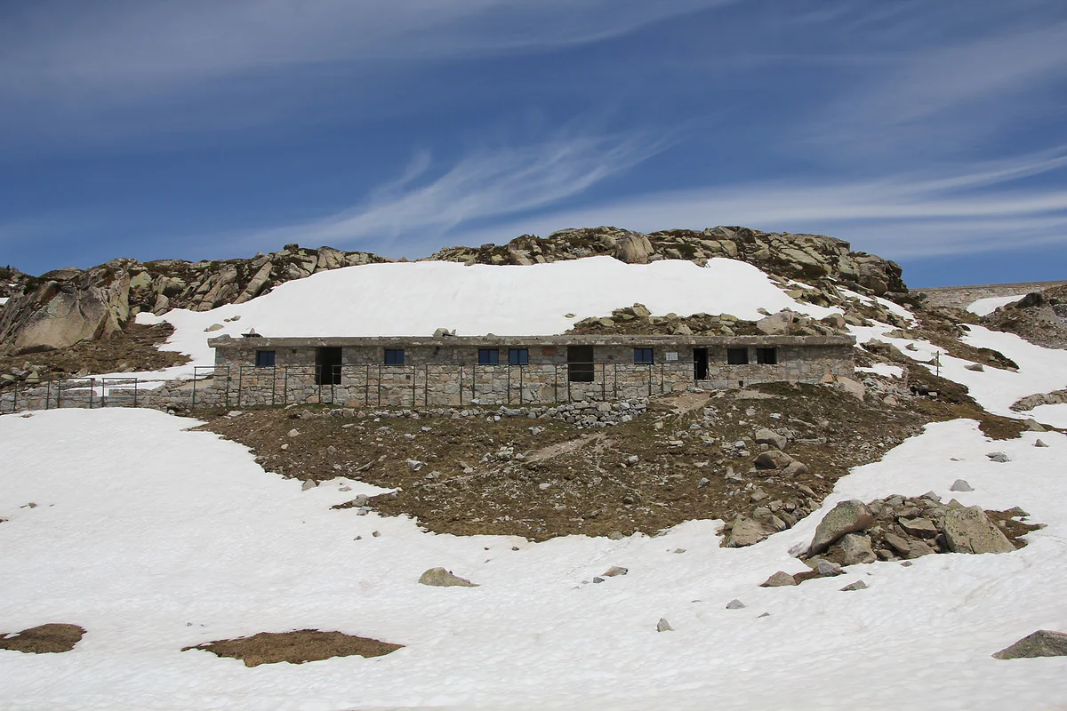
This is one of its selling points. The GRP passes all four staffed huts in the country, l’Illa, Juclar, Borda de Sorteny and Comapedrosa, with dinner and a bed. The other nights are in unstaffed huts, such as Claror or Pla de les Pedres, free and open all year but with no warden and no food.
The official sheet is dated in places, mentioning 2014 and giving bed numbers that don’t match the Madriu valley’s own site, and on stages three and five it suggests a valley hotel as an alternative. I’d trust each hut’s own website for capacity and book the staffed ones before setting off. I list them all in mountain huts in Andorra.
GRP or Coronallacs?
It’s the usual question, since both loop the country. The Coronallacs is 92 km in five stages and always sleeps in the four staffed huts, starting and finishing in Escaldes-Engordany. The GRP is longer, about 110 km in seven, and in return reaches further south through Sant Julià, with at least one night in an unstaffed hut.
If you have five days and want a hot dinner every night, go for the Coronallacs. If you have a week, can cope in a basic hut and want to see southern Andorra too, choose the GRP.
Before you set off
Walk it in July, August or September, or from the last week of June, which is the window Andorra Turisme recommends up high. Pick up the free hut passport from any tourist office before you start, because handing it in stamped in Andorra la Vella earns you a certificate and a prize. For British trekkers, two things are non-negotiable on a week in the mountains. The UK health card isn’t accepted in Andorra, so take out insurance that covers mountain rescue, and leave your day-by-day itinerary with someone at home. On the route itself, the first stage climbs from Aixovall past Juberri and Auvinyà into the Rabassa forest.
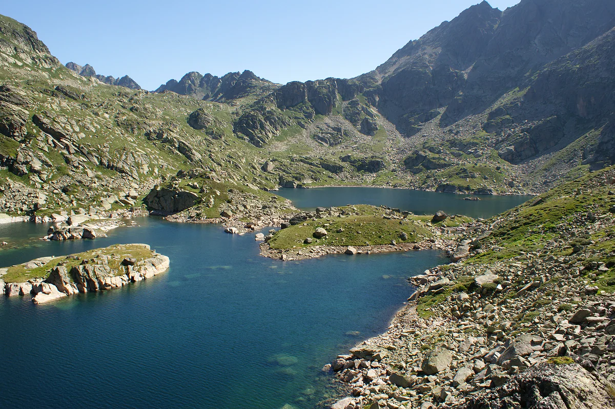
The Juclar lakes, a glacial lake of clear blue water dotted with islets and ringed by granite peaks
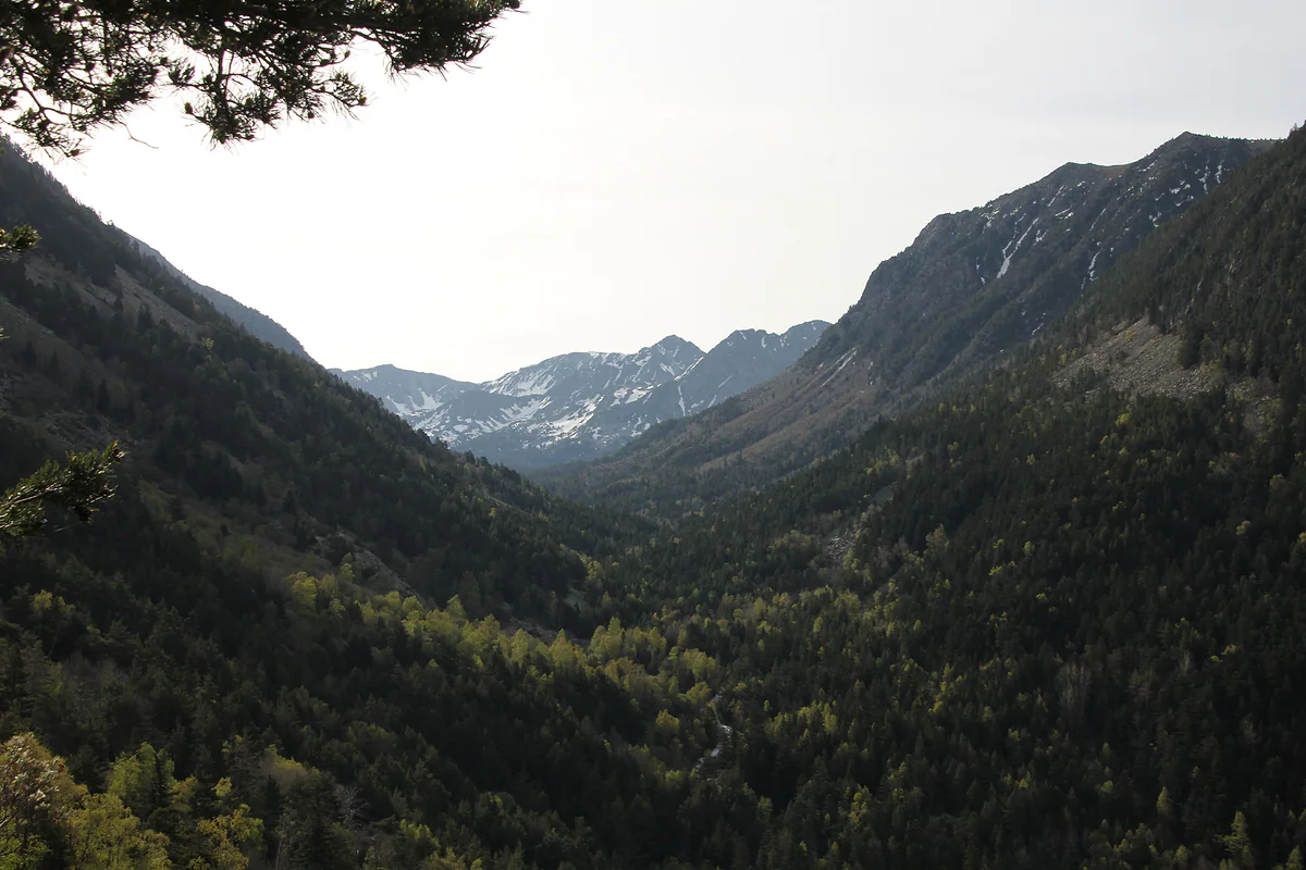
The Madriu-Perafita-Claror valley, a World Heritage site, with forested slopes and peaks beyond
The seven GRP stages from the official sheet
| Stage | Distance | Height gain | Time | Grade |
|---|---|---|---|---|
| 1. Aixovall to Claror hut | 24.1 km | 2,000 m | 8 hrs 30 | Medium |
| 2. Claror to l'Illa hut | 12.57 km | 712 m | 5 hrs 45 | Low |
| 3. L'Illa to Peretol (Grau Roig) | 12.13 km | 396 m | 6 hrs | Medium |
| 4. Peretol to Juclar hut | 10.36 km | 1,061 m | 4 hrs 30 | Medium |
| 5. Juclar to Ordino via Sorteny | 20.7 km | 1,512 m | 8 hrs 15 | No grade given |
| 6. Ordino to Comapedrosa hut | 19.26 km | 2,206 m | 8 hrs | High |
| 7. Comapedrosa to Aixovall | 19.58 km | 1,323 m | 8 hrs 15 | High |
Andorra Turisme GRP route sheet, checked on 29-09-2026. Parts of it are dated (it mentions 2014), so I use distances, height gain, times and waypoints, not the bed numbers or hotels it lists.
Test yourself
True or false?
0/3 Pick before you peek.
-
The GRP is a linear trail crossing Andorra from north to south.
See the answer
False. It's a loop of about 110 km in seven stages, and you can start at any of its four access points.
-
The GRP's high point is 2,829 m, just before the Pessons col.
See the answer
True. The official sheet gives it on stage three, just before the Collado dels Pessons at 2,810 m.
-
You collect the GRP certificate at any staffed hut.
See the answer
False. You hand in the stamped hut passport at the Andorra la Vella tourist office, which gives you the certificate and a gift.
- Full loop
- ~110 km
- Stages
- 7
- Highest point on the route
- 2,829 m
0 of 269 Andorra guides
Your next stamp
- Coronallacs
- GR11 and other GRs
- Hiking
- Skiing
- Ski touring
- Grandvalira
- Climbing
- Places to visit
- Things to do
- Most beautiful places
- Prettiest villages
- Andorra la Vella
- UNESCO World Heritage
- Map
- Escaldes-Engordany
- Where is Andorra?
- Is Andorra a country?
- Parishes
- Casa de la Vall
- Margineda bridge
- Old town
- Santa Coloma church
- Towns and villages
- Population
- Size
- Mountains
- Language
- Andorra in one day
- Canillo
- Espai Columba
- History
- Margineda rock shelter
- Sant Esteve church
- Co-princes
- Soldeu
- Weekend break
- Andorra in 3 days
- El Tarter
- Political system
- Andorra in 4 days
- Flag
- Ransol
- A week in Andorra
- Facts
- Prats
- El Forn
- Public holidays
- Sant Julià de Lòria
- Currency and payments
- L'Aldosa de Canillo
- Els Plans
- EU and Schengen
- Bordes d'Envalira
- Entry requirements
- Prices and budget
- On a budget
- Sant Joan de Caselles
- Santa Coloma
- Ski holidays
- Tourist tax
- Mobile and roaming
- Sant Serni de Canillo
- Tourist information
- Healthcare
- Meritxell Sanctuary
- With a dog
- Packing list
- Safety
- How to get there
- Scams
- From Barcelona
- Bus from Barcelona
- Day trip from Barcelona
- From Madrid
- From Toulouse
- Encamp
- Flights
- La Margineda
- La Massana
- Roc del Quer viewpoint
- Romanesque churches
- Andorra-La Seu airport
- Canillo Tibetan bridge
- Museums in Andorra
- Pal
- Pas de la Casa
- Arinsal
- Driving
- Grau Roig
- Mon(t) Magic
- Nearest airports
- By train
- Erts
- Les Bons
- Palau de Gel
- Road conditions
- Motorcycle Museum
- Parking
- Sispony
- Vila
- Anyós
- Incles valley
- La Mosquera
- Petrol
- El Tremat
- Getting around
- Juclar lakes
- L'Aldosa (La Massana)
- Buses
- Els Cortals d'Encamp
- Sant Climent de Pal
- Bus station
- Sant Cristòfol d'Anyós
- Casa Rull
- Shopping
- Farga Rossell
- Sant Vicenç d'Enclar
- Santa Eulàlia d'Encamp
- What to buy
- Customs allowances
- La Massana Còmic
- Sant Romà de les Bons
- Car Museum
- Cigarettes
- Comapedrosa
- Electronics
- Alcohol
- Casa Cristo
- Clothes and sports shops
- Iron Route
- Coll d'Ordino
- Perfume
- Sacred Art Museum
- Shopping centres
- Funicamp
- Supermarkets
- Avinguda Meritxell
- Encamp Tibetan bridge
- Avinguda Carlemany (Vivand)
- Envalira pass
- Auvinyà
- Bici Lab Andorra
- Ordino
- With kids
- Zip lines
- Fontaneda
- For couples
- La Cortinada
- Ski pass
- Via ferratas
- Llorts
- Nagol
- Nightlife
- Ski season
- El Serrat
- Horse riding
- Juberri
- Aixovall
- Mountain biking
- Pal Arinsal
- Sornàs
- Aixirivall
- Ansalonga
- Ordino Arcalís
- Road cycling
- Bixessarri
- Naturland
- Segudet
- Arans
- Llumeneres
- Tobotronc
- Casa d'Areny-Plandolit
- Cross-country skiing
- Miniature Museum
- Skiing with kids
- Cal Pal
- Free walking tour
- Pessons lakes
- Sant Serni de Nagol
- Ski lessons
- Where to stay
- Canòlich Sanctuary
- Hotels in Andorra la Vella
- Sant Martí de la Cortinada
- Ski hire
- Hotels in Escaldes
- Juberri Gardens
- Llorts iron mine
- Webcams
- Hotels in Soldeu
- Snow report
- Sorteny valley
- Hotels in El Tarter
- Tristaina lakes
- Hotels in Canillo
- Night skiing
- Tristaina solar viewpoint
- Freeride
- Hotels in Encamp
- Hotels in Pas de la Casa
- Hotels in La Massana
- Snowshoeing
- Hotels in Arinsal and Pal
- Snow activities
- Après-ski
- Engordany
- Hotels in Ordino
- Medieval bridges
- Nature parks
- Els Vilars
- Hotels in Sant Julià de Lòria
- Lakes
- Sant Romà dels Vilars
- Viewpoints
- Where to eat
- Caldea
- Restaurants in Andorra la Vella
- Borda restaurants
- Inúu
- Cheap hotels
- Food
- Spas and thermal baths
- Weather and climate
- Engolasters lake
- Pas de la Casa weather
- Spa hotels
- Trinxat
- Events
- Luxury hotels
- Sant Miquel d'Engolasters
- Ski resort weather
- Wine
- Best time to visit
- Family hotels
- Madriu valley
- All inclusive
- Estany de l'Illa
- In winter
- Apartments
- In spring
- Ski World Cup
- Christmas
- Hostels
- In summer
- Mountain huts
- Camping and rural stays
- Easy walks
- In autumn
- New Year
- Family walks
- Festes majors
- In January
- In February
- National day
- Around Andorra
- In March
- Midsummer fire festival
- Carnival
- In April
- In May
- Travessa d'Encamp
- In June
- In July
- In August
- In September
- In October
- In November
- In December
Frequently asked questions
What is the GRP in Andorra?
It's the country's own long-distance trail, a circular route of about 110 km that loops round Andorra in seven stages of 10 to 24 km, sleeping in mountain huts. In places it shares the line of the GR7, the GR11 and the GRT 1 and 2.
How many days does the GRP take?
Seven, one stage a day, according to the official sheet. Stages run from 4 hrs 30 to 8 hrs 30 of walking, so there isn't much slack for long breaks.
Where do you start the GRP?
At any of its four access points, Aixovall (Sant Julià de Lòria), Bordes d'Envalira (between Soldeu and Grau Roig), the Incles valley (Canillo) or Llorts (Ordino). The sheet describes it starting from Aixovall.
Should I do the GRP or the Coronallacs?
The Coronallacs is 92 km in five stages and always sleeps in the four staffed huts. The GRP is longer, about 110 km in seven, passes those four too and adds nights in unstaffed huts.
How hard is the GRP?
Andorra Turisme grades it very hard. Some stages climb over 2,000 m and the high point is 2,829 m, so it calls for multi-day trekking experience and good fitness.
When is the best time to walk the GRP?
High summer, late June to late September, which is when Andorra Turisme recommends routes above 1,700 m. In June there can still be snow on the high cols.
By
Tourism graduate with a master’s in Tourism Management and Planning from the University of Málaga, who has travelled across Europe. He writes every guide from official sources and his own judgement.
Published on . Facts checked on .
Sources
Photos: Ferran Llorens (CC BY-SA 2.0); Ferran Llorens (CC BY-SA 2.0); Ferran Llorens (CC BY-SA 2.0), via Wikimedia Commons.