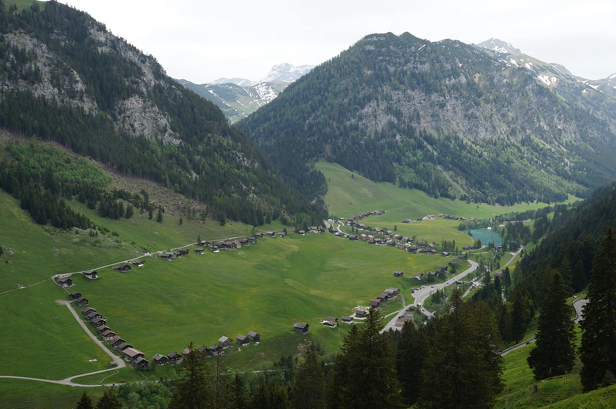
Triesenberg summer pasture at about 1,300 m
Steg, where the huts circle the meadow in the Samina valley
Steg is a settlement in Triesenberg at about 1,300 m in the upper Samina valley, where wooden huts form a ring around the hay meadow. It lies beyond the Kulm tunnel on the way to Malbun, has a reservoir built in 1947-1948 and the country's only cross-country skiing area, and route 21 links it with Vaduz in about 25 minutes.
In 30 seconds
Full read: 3 min
- Steg is a Triesenberg settlement at about 1,300 m in the upper Samina valley.
- Its huts ring the hay meadow, a layout protected by planning rules.
- It has a reservoir from 1947-1948 and the country's only cross-country ski area.
- Route 21 gets there from Vaduz in about 25 minutes.
I'd get off at Steg, Tunnel, walk round the outside of the Grosssteg ring and follow the reservoir path towards Valüna. It's the easiest walk in the country's mountains and the one that best shows how the Walser lived.

Before you go
What I would keep in mind
-
01 Most beautiful
A ring of huts around the meadow
The huts surround the meadow like a fence. Inside, each family mowed its own hay plot; outside, the grazing was shared. Planning rules from 1965, 1979 and 2000 protect the layout.
-
02 My tip
The Walser Museum's old hut
By the chapel, at the fork for Steg and Kleinsteg, stands the Alte Maiensässhütte, a log byre extended with a dairy in 1896. You see it on a guided visit booked through the Walser Museum.
the Walser Museum in Triesenberg -
03 Getting there
Route 21, about 25 minutes from Vaduz
The bus leaves Vaduz, Post, climbs through Triesenberg and the Kulm tunnel and stops at Steg FL, Tunnel and Steg FL, Hotel. It runs on to Steg once an hour. Pay by card or app.
Liechtenstein's buses -
04 To save money
Free cross-country skiing for under-16s
On the Steg-Valüna trails under-16s ski free. Adults pay CHF 10 a day, according to the club that grooms them.
cross-country skiing at Steg
What I would book
Come out of the Kulm tunnel on the way to Malbun and the first thing you see is a huge meadow ringed with wooden huts, as if someone had drawn a circle with them. That’s Steg. To me it’s the most original man-made landscape in Liechtenstein, and it deserves more than a glance from the bus window.
Why are the huts at Steg in a ring?
Steg sits at about 1,300 m in the upper Samina valley, where the Valüna, Valorsch and Malbun valleys branch off. It takes its name from the footbridge over the Samina, and the Malbunbach splits it in two, Grosssteg and Kleinsteg. The Historisches Lexikon records it in 1516, although Walser settlers were granted Grosssteg on a hereditary lease as early as 1355.
The ring has a logic to it. Inside is an almost flat hay meadow that each family mowed on its own plot; outside is shared pasture. The huts formed a fence between the two, stored the hay and housed the cattle in autumn until close to Christmas. The interesting bit, according to the Lexikon, is that current research sees it neither as a Romansh legacy nor as a Walser custom, but as the natural result of that way of farming. Grazing rights were recorded as notches on tally sticks called «Beigla».
Best of all, the ring is still there. The oldest hut in Grosssteg has been dated to 1623, and the numbers have barely moved in over a century, from 62 to 77 huts in Grosssteg and from 44 to 43 in Kleinsteg between 1880 and 2000. Planning rules from 1965, 1979 and 2000 protect the layout. The outer pasture is still run as a cooperative, with 150.2 hectares and 210 grazing rights on the Grosssteg alp and 161.9 hectares and 216 rights on Kleinsteg, held by members who, the Lexikon says, are now mostly not farmers.
What I’d see in Steg
I’d start with the chapel of St Wendelin and St Martin, at 1,316 m, which grew out of a small wayside shrine and took its present form in 1906-1907, with a round tower and conical roof designed by Egon Rheinberger. Next to it, at the fork for Kleinsteg, is the Alte Maiensässhütte, a log hut extended with a dairy in 1896 and moved and listed in 2009. It’s shown only on guided visits run by the Walser Museum in Triesenberg, so ask in advance.
Then I’d head down to the reservoir. It was built in 1947-1948 for the Samina power scheme, sits at 1,296 m and covers 3.2 hectares; from here the water tunnels through the mountain to Masescha and drops to Vaduz. The path round it continues along the stream towards Valüna, which I cover on my page about the Samina valley.
From customs post to winter village
Steg has reinvented itself more than once. It had a sawmill driven by a water wheel on the Malbunbach until 1939, and from 1924 to 1972 a customs post for the Swiss border guards patrolling the Austrian frontier in the mountains. Tourism came late, with a spa guesthouse in 1925 and the first holiday home in 1944. What changed everything was the new Gnalp-Steg tunnel, opened on 4 December 1947.
This is also where skiing in the country started. Liechtenstein’s first two ski lifts were put up at Steg in 1950 and 1952. In the 1960s downhill skiing moved to Malbun, and Steg kept cross-country skiing and sledging.
Steg in winter
Steg-Valüna is, according to the club that runs it, the only cross-country skiing area in the country, between 1,310 and 1,450 m, with trails groomed from December to mid-March and a floodlit night loop. I go into detail in my guide to cross-country skiing at Steg. And for children there’s sledging, as the Lexikon notes a natural run on the road down from the Kulm by Sücka since 1963.
Getting there and where to eat
LIEmobil route 21 leaves Vaduz, Post, climbs through Triesenberg, goes through the tunnel and stops at Steg FL, Tunnel and Steg FL, Hotel, in about 25 minutes. It runs on to Steg once an hour. Cash isn’t taken on board.
For food, the tourist board lists the Bergstübli and the Restaurant Seeblick in Steg. For a bed, the statistics office groups Steg and Malbun together as the country’s Alpine hotel area. And if you’re heading for the Pfälzerhütte, the Alpine Club reckons two to three hours from Steg, climbing through Valüna.
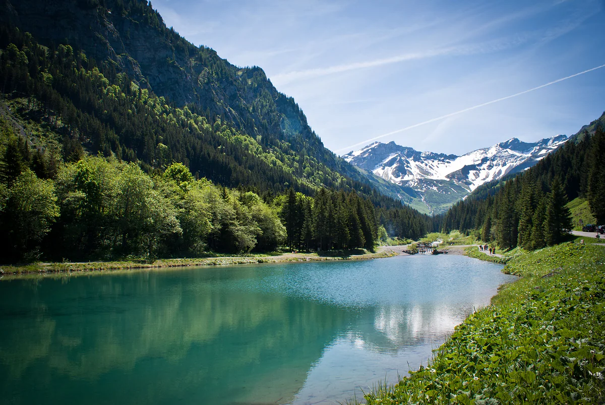
The Steg reservoir, with turquoise water, surrounded by forest and with snowy peaks at the end of the valley.
Steg in numbers
| Fact | Figure | Source |
|---|---|---|
| Altitude | About 1,300 m | Historisches Lexikon |
| Huts in Grosssteg | 62 in 1880, 77 in 2000 | Historisches Lexikon |
| Huts in Kleinsteg | 44 in 1880, 43 in 2000 | Historisches Lexikon |
| Oldest dated hut | 1623 | Historisches Lexikon |
| Reservoir | 1,296 m, 3.2 ha, built 1947-1948 | Historisches Lexikon |
| Chapel of St Wendelin and St Martin | 1,316 m | Historisches Lexikon |
Getting to Steg
| How | Detail |
|---|---|
| Bus | Route 21 from Vaduz, Post to Steg FL, Tunnel, about 25 minutes, hourly |
| Car | Via Triesenberg and the Gnalp-Steg tunnel of 1947 |
| On foot from Malbun | Path opened in 1956, according to the Lexikon |
Official 2026 timetable for route 21. LIEmobil buses don't take cash.
Test yourself
True or false?
0/3 Pick before you peek.
-
The ring of huts at Steg is a typical Walser custom.
See the answer
False. According to the Historisches Lexikon, current research puts it down to how the land was worked, not to a Romansh tradition or a specifically Walser one.
-
Liechtenstein's first two ski lifts were built at Steg.
See the answer
True. They went up in 1950 and 1952. In the 1960s downhill skiing moved to Malbun and Steg kept cross-country skiing and sledging.
-
Steg had a customs post until 1972.
See the answer
True. After the 1924 customs treaty with Switzerland, a post was set up for the Swiss border guards watching the Austrian frontier in the mountains. It closed in 1972.
- Approximate altitude
- 1,300 m
- Oldest dated hut in Grosssteg
- 1623
- Liechtenstein's first ski lift, at Steg
- 1950
- By bus from Vaduz, Post
- 25 min
Map
Where Steg is
The dashed line is the border: Switzerland across the Rhine, Austria to the north and east. Every number opens its guide.
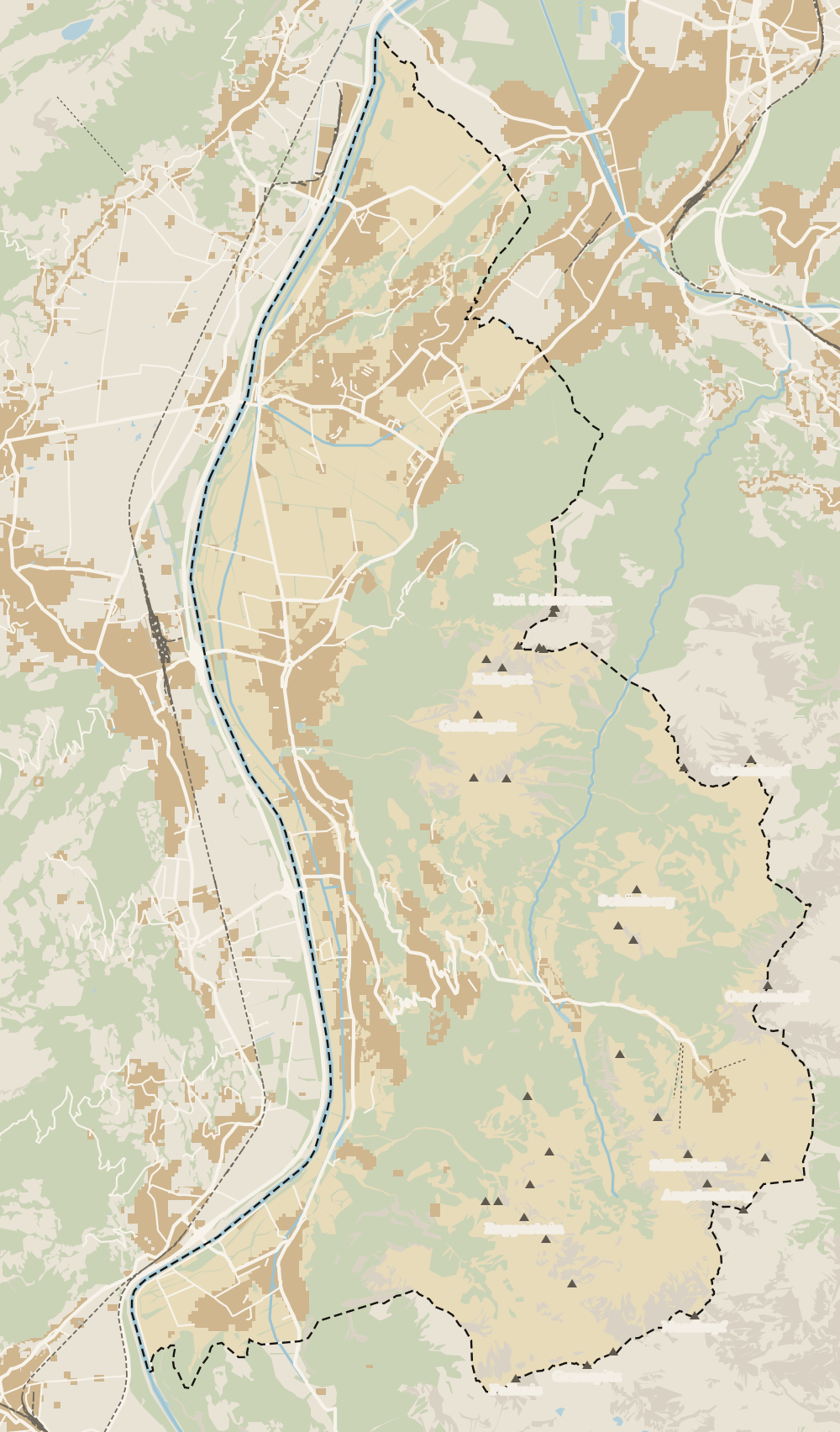 1Triesenberg 2Walser Museum 3Masescha 4Gaflei 5Silum 6Rotenboden 7Wangerberg 8Steg 9Samina valley 10Malbun
 Map data © OpenStreetMap contributors (ODbL)
- 1TriesenbergLargest and highest municipality in the country
- 2Walser MuseumClosed from 12:00 to 15:00
- 3MaseschaTriesenberg hamlet at 1,250 m
- 4GafleiHome of the country's first spa hotel, in 1875
- 5SilumWalser alp between 1,400 and 1,700 m
- 6RotenbodenTriesenberg hamlet, Rotaboda in dialect
- 7WangerbergTriesenberg hamlet, Wangerbärg in dialect
- 8StegTriesenberg summer pasture at about 1,300 m
- 9Samina valleyThe inner valley behind the Kulm ridge
- 10MalbunAt 1,600 m, with an hourly bus from Vaduz
What to see
What to see in Steg
0 of 168 Liechtenstein guides
Your next stamp
- Cross-country skiing at Steg
- Malbun
- In winter
- Pfälzerhütte
- Things to do
- Mountain huts
- Christmas
- Hut-to-hut Route 66
- One day
- Two days
- Municipalities
- Oberland
- Unterland
- Map
- Vaduz
- Städtle
- Mitteldorf
- Vaduz Castle
- Vaduz Cathedral
- Parliament
- Government Building
- Vaduz Town Hall
- Red House
- Prince's Winery
- Old Rhine Bridge
- Schaan
- Schalun Castle Ruin
- Balzers
- Citytrain
- Triesen
- Triesenberg
- Walser Museum
- Planken
- Gutenberg Castle
- The Rhine
- Schaan Roman fort
- Dux
- St Mamertus chapel
- Lawena valley
- Mäls
- DoMuS
- TAK Theatre
- Castles
- Churches and chapels
- Viewpoints
- Mountains
- Museums
- Kunstmuseum
- Hilti Art Foundation
- Gafadura hut
- National Museum
- Treasure Chamber
- Postage Stamp Museum
- Kunstraum Engländerbau
- Eschen
- Masescha
- Gaflei
- Nendeln
- Mauren
- Silum
- Rotenboden
- Schaanwald
- Gamprin
- Wangerberg
- Bendern
- Ruggell
- Samina valley
- Schellenberg Farmhouse Museum
- Küefer-Martis-Huus
- Ruggeller Riet
- Schellenberg
- Hinterschellenberg
- Fürstensteig
- Is it a country?
- Liechtenstein Trail
- Schellenberg castles
- Eschnerberg
- Malbun in summer
- Population
- Stage 1: Balzers - Triesenberg
- Lakes
- Sareis
- Size
- Stage 2: Triesenberg - Vaduz
- Malbun Peace Chapel
- Political system
- Stage 3: Vaduz - Nendeln
- Swimming pools
- Language
- Skiing in Malbun
- Stage 4: Nendeln - Ruggell
- Dialect
- Malbun ski pass
- Stage 5: Ruggell - Schaanwald
- Hotels in Malbun
- Stamps
- Princess Gina Trail
- Hiking
- Getting there
- Weather
- Airport
- Best time to visit
- In summer
- Events
- With kids
- Zurich to Liechtenstein
- National day
- Sargans to Vaduz
- Feldkirch to Vaduz
- By train
- Traditions
- Carnival
- Getting around
- Buses
- Funken Sunday
- Alpine cattle drive
- Driving and vignette
- Parking
- Bike hire
- Cycling
- EU and Schengen
- Entry requirements
- Borders and customs
- The prince
- The princely house
- The flag
- The coat of arms
- The national anthem
- History
- Second World War
- No army
- Facts
- Why so rich?
- Banks and tax haven
- Where to stay
- Hilti
- Hotels in Vaduz
- False teeth
- Hostel and camping
- Rent the country?
- Where to eat
- Restaurants in Vaduz
- Swiss invasions
- Bars and nightlife
- Food
- Käsknöpfle
- Wine
- Casinos
- Adventure Pass
- Rainy days
- Guided tours
- Tourist office
- Day trips
- Passport stamp
- Music festivals
- Phone and roaming
- Currency and payments
- Prices and budget
- Tipping
- Plugs and sockets
- Tap water
- Opening hours
- Public holidays
- Safety
- Accessibility
- With a dog
- Shopping and souvenirs
Frequently asked questions
What is Steg in Liechtenstein?
A settlement in the municipality of Triesenberg at about 1,300 m in the upper Samina valley, known for its huts arranged in a ring round the meadow. It sits between the Kulm tunnel and Malbun.
How do I get to Steg?
Take LIEmobil route 21 from Vaduz, Post; it reaches Steg FL, Tunnel in about 25 minutes and carries on to Malbun. By car, drive up through Triesenberg and the Gnalp-Steg tunnel.
What is there to do in Steg?
Walk round the ring of huts, see the chapel of St Wendelin and St Martin, stroll by the reservoir towards Valüna and, in winter, go cross-country skiing on the Steg-Valüna trails, the only ones in the country.
Why are the huts at Steg arranged in a circle?
According to the Historisches Lexikon, because of how the land was farmed. Inside the ring was the hay meadow, split into plots, and outside was shared pasture. The huts stored hay and housed the cattle in autumn.
Is Steg the same as Malbun?
No. They're two mountain settlements in Triesenberg. Steg is at about 1,300 m and is mainly about cross-country skiing and walks; Malbun is higher, at about 1,600 m, and has the downhill ski area.
Where can I eat in Steg?
The tourist board lists the Bergstübli and the Restaurant Seeblick in Steg. On the Kulm side there's also the Berggasthaus Sücka.
By
Tourism graduate with a master’s in Tourism Management and Planning from the University of Málaga, who has travelled across Europe. He writes every guide from official sources and his own judgement.
Published on . Facts checked on .
Sources
Photos: albinfo (CC0); Clemens v. Vogelsang from Liechtenstein (CC BY 2.0), via Wikimedia Commons.