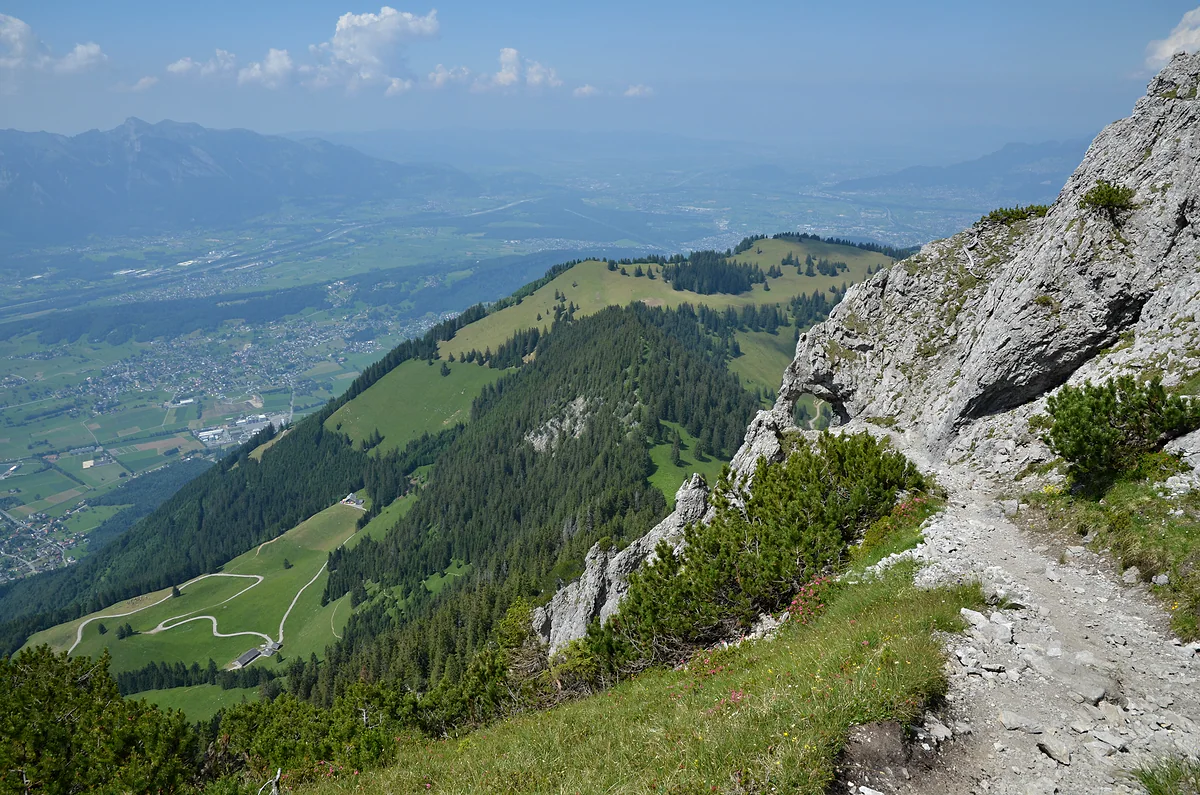
Opened in 1898, from Gaflei to the Drei Schwestern
The Fürstensteig, the prince's path above the Rhine valley
The Fürstensteig is the most dramatic section of the Drei Schwestern path, opened from Gaflei in 1898 and partly paid for by Prince Johann II. The tourist board gives the full traverse to Planken as 11.9 km, about five and a half hours and 1,540 m of descent, on secured rock paths suitable only for sure-footed walkers.
In 30 seconds
Full read: 3 min
- The Fürstensteig is the most dramatic part of the Drei Schwestern path, opened in 1898.
- It starts at Gaflei, served by bus 22.
- The traverse to Planken is 11.9 km and about five and a half hours.
- It has secured rock sections and is only for sure-footed walkers.
- There can be snowfields until late spring.
I'd do it from Gaflei to Planken, which is downhill overall, starting early on route 22 with the forecast checked the night before. If you're unsure about exposure, just do the first stretch and turn back to Gaflei; even that is worth it.

Before you go
What I would keep in mind
-
01 Most beautiful
From the Rhine to Lake Constance
The tourist board ranks it among the country's most impressive mountain routes, with views over the Rätikon, down the Rhine valley and as far as Lake Constance.
mountains in Liechtenstein -
02 Watch out
It's not a stroll, even if it starts at a car park
It has secured rock sections and the Alpine Club grades parts as an alpine route. The tourist board warns of snowfields until late spring and asks you to check conditions first.
hiking in Liechtenstein -
03 Getting there
Bus 22 up, bus 26 back
Route 22 climbs from Triesenberg to Gaflei in 12 or 13 minutes. At the end, in Planken, route 26 runs down to Schaan. The buses don't take cash.
Liechtenstein's buses -
04 Worth the splurge
Sleep at Gaflei or at Gafadura
Berggasthaus MATU at Gaflei has rooms so you can start fresh, and the Gafadura hut, near the end, has 14 places if you'd rather split the route over two days.
the Gafadura hut
What I would book
If there’s one mountain route in Liechtenstein with a name people recognise, this is it. The Fürstensteig leaves Gaflei, clings to the rock high above the Rhine valley and carries on along the ridge to the Drei Schwestern. For me it’s the finest walk in the country for anyone who knows their way around mountains, and that’s exactly why I want to set it out with every warning attached.
A path built for tourists in 1898
The Fürstensteig isn’t an old herders’ track that someone waymarked later. The Historisches Lexikon explains that the Drei Schwestern path was built in 1897-1898 between those peaks and the spa house at Gaflei, at the suggestion of the Vorarlberg section of the German and Austrian Alpine Club, with engineer Karl Schädler doing the work. It runs for 6.4 km at between 1,700 and about 2,000 m and is partly hewn out of the rock.
The most spectacular stretch, 2.2 km long, was paid for by Prince Johann II, hence the name Fürstensteig, the prince’s path. It opened in 1898, the 40th year of his reign, and the Lexikon counts it as a landmark in the history of Alpine tourism in the country. So much so that it sparked the idea of founding Liechtenstein’s own Alpine club, which finally came about in 1909.
How hard is the Fürstensteig?
No point kidding yourself here. The tourist board sells it as an unforgettable experience for sure-footed walkers on secured rock paths. The municipality of Planken, describing the route over the Drei Schwestern, adds that you need a head for heights, and the Alpine Club grades the classic traverse as an alpine route, the white-blue-white category that calls for kit and experience.
There’s a second warning. The tourist board says there can be snowfields until late spring and asks you to check the path’s condition before you go. I’d look at the forecast the night before and wouldn’t go in a storm, on wet rock or with small children.
The traverse, step by step
The version the tourist board describes runs from Gaflei to Planken over the Fürstensteig and the Drei Schwestern. It’s 11.9 km, about five and a half hours, 819 m up and 1,540 m down, with a high point of 2,052 m. The views, the same source says, take in the Rätikon and the Rhine valley and stretch as far as Lake Constance.
Near the end you reach the Gafadura hut, at 1,428 m, the Alpine Club’s refuge above Planken, which the tourist board suggests as the place to refuel before dropping to the village. If you want to split the route, you can sleep there, booking by email and paying in cash only.
Three ways to do it
Between its list of popular routes and its Gafadura hut page, the Alpine Club gives three combinations. The classic one, which is what I’d do, carries on over the Kuhgrat and the Drei Schwestern to Gafadura and Planken. A variant skips the pinnacles and goes down via the Kuegrat, the Garsellikopf and the Sarojasattel to Gafadura, in about four hours on white-red-white waymarks. And there’s a loop back to Gaflei via the Kamin, the Alpspitz and the Bargälla alp, also graded as an alpine route.
The legend of the Drei Schwestern, three sisters turned to stone for refusing to share their berries, is on my page about Planken, which is where you get the best look at them.
Getting there and back
To start, take route 21 from Vaduz to Triesenberg and then route 22 to Gaflei, 12 or 13 minutes. The 22 runs once an hour; I’d catch the first one that suits so I’m not rushed. At the end, in Planken, route 26 takes you down to Schaan. On every bus you pay by card or app, never cash.
If you’d rather have it organised, the tourist board sold a three-day package in 2026 from mid-June to early October, at CHF 339 per person, with a night at the Pfälzerhütte, another at Gaflei or Triesenberg, half board and a bus and chairlift pass. Its third day is exactly this traverse, Gaflei to Planken in about five hours, and it asks for mountain experience, good fitness, a sure foot and a head for heights. I cover it on my page about the hut-to-hut Route 66.
One more thing for August. On the night of the 2026 national day there was, according to the official programme, a procession of lights along the Fürstensteig. For the rest of the country’s walks, see my guide to hiking in Liechtenstein.
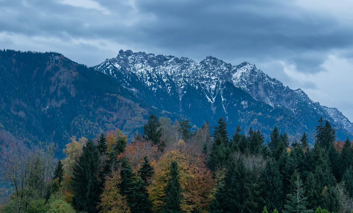
The Three Sisters, rocky snow-dusted peaks above the autumn forest, under grey clouds.
Fürstensteig - Drei Schwestern route card
| Fact | Figure |
|---|---|
| Start | Gaflei |
| Finish | Planken, via the Gafadura hut |
| Distance | 11.9 km |
| Time | About 5 h 30 min |
| Ascent and descent | +819 m and -1,540 m |
| Highest point | 2,052 m |
Figures from the tourist board (archive.org copy of 25 July 2026). The Alpine Club gives about four and a half hours from Gaflei to the Gafadura hut over the Drei Schwestern.
Three ways to do it, according to the Alpine Club
| Option | Route | Waymark |
|---|---|---|
| Classic | Gaflei, Fürstensteig, Kuhgrat, Drei Schwestern, Gafadura hut, Planken | Alpine route |
| Via the Sarojasattel | Gaflei, Fürstensteig, Kuegrat, Garsellikopf, Sarojasattel, Gafadura hut, about 4 h | White-red-white |
| Loop | Gaflei, Fürstensteig, Kamin, Alpspitz, Bargälla alp, Gaflei | Alpine route |
Test yourself
True or false?
0/4 Pick before you peek.
-
Prince Johann II paid for the whole Fürstensteig path.
See the answer
False. The prince paid for the 2.2 km Fürstensteig section. The rest of the Drei Schwestern path was funded by the Vorarlberg section of the Alpine Club and engineer Karl Schädler, according to the Historisches Lexikon.
-
The path opened in 1898, the 40th anniversary of Johann II's reign.
See the answer
True. The Lexikon describes it as one of the landmark events in the history of Alpine tourism in the country.
-
The Fürstensteig is suitable for any walker.
See the answer
False. The tourist board recommends it only for sure-footed walkers on secured rock paths and warns of snowfields until late spring.
-
The idea of founding Liechtenstein's Alpine club came from this path.
See the answer
True. According to the Historisches Lexikon, the idea arose while the path was being built in 1897-1898, although the club wasn't founded until 1909.
- The path opens
- 1898
- Fürstensteig section, paid for by the prince
- 2.2 km
- Full traverse to Planken
- 11.9 km
- Highest point on the route
- 2,052 m
Map
Where Fürstensteig is
The dashed line is the border: Switzerland across the Rhine, Austria to the north and east. Every number opens its guide.
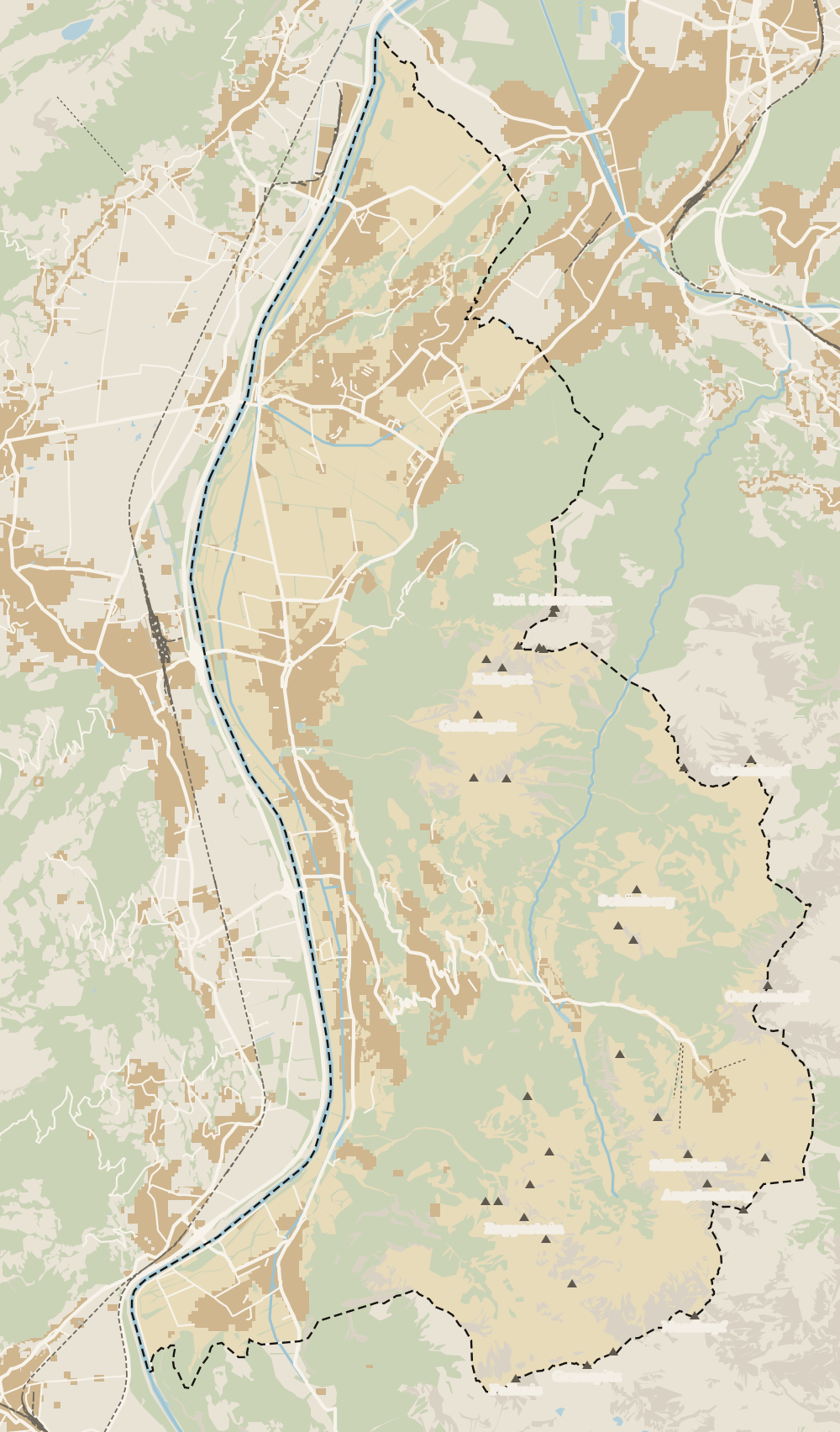 1Fürstensteig 2Liechtenstein Trail 3Princess Gina Trail
 Map data © OpenStreetMap contributors (ODbL)
0 of 168 Liechtenstein guides
Your next stamp
- Gaflei
- Hut-to-hut Route 66
- Hiking
- Planken
- Viewpoints
- Mountain huts
- Princess Gina Trail
- Stage 1: Balzers - Triesenberg
- Things to do
- One day
- Two days
- Municipalities
- Oberland
- Unterland
- Map
- Vaduz
- Städtle
- Mitteldorf
- Vaduz Castle
- Vaduz Cathedral
- Parliament
- Government Building
- Vaduz Town Hall
- Red House
- Prince's Winery
- Old Rhine Bridge
- Schaan
- Schalun Castle Ruin
- Balzers
- Citytrain
- Triesen
- Triesenberg
- Walser Museum
- Gutenberg Castle
- The Rhine
- Schaan Roman fort
- Dux
- St Mamertus chapel
- Lawena valley
- Mäls
- DoMuS
- TAK Theatre
- Castles
- Churches and chapels
- Mountains
- Museums
- Kunstmuseum
- Hilti Art Foundation
- Pfälzerhütte
- Gafadura hut
- National Museum
- Treasure Chamber
- Postage Stamp Museum
- Kunstraum Engländerbau
- Eschen
- Masescha
- Nendeln
- Mauren
- Silum
- Rotenboden
- Schaanwald
- Gamprin
- Wangerberg
- Bendern
- Steg
- Ruggell
- Samina valley
- Schellenberg Farmhouse Museum
- Cross-country skiing at Steg
- Küefer-Martis-Huus
- Ruggeller Riet
- Schellenberg
- Hinterschellenberg
- Is it a country?
- Liechtenstein Trail
- Malbun
- Schellenberg castles
- Eschnerberg
- Malbun in summer
- Population
- Lakes
- Sareis
- Size
- Stage 2: Triesenberg - Vaduz
- Malbun Peace Chapel
- Political system
- Stage 3: Vaduz - Nendeln
- Swimming pools
- Language
- Skiing in Malbun
- Stage 4: Nendeln - Ruggell
- Dialect
- Malbun ski pass
- Stage 5: Ruggell - Schaanwald
- Hotels in Malbun
- Stamps
- Getting there
- In winter
- Weather
- Airport
- Best time to visit
- In summer
- Events
- With kids
- Zurich to Liechtenstein
- National day
- Sargans to Vaduz
- Christmas
- Feldkirch to Vaduz
- By train
- Traditions
- Carnival
- Getting around
- Buses
- Funken Sunday
- Alpine cattle drive
- Driving and vignette
- Parking
- Bike hire
- Cycling
- EU and Schengen
- Entry requirements
- Borders and customs
- The prince
- The princely house
- The flag
- The coat of arms
- The national anthem
- History
- Second World War
- No army
- Facts
- Why so rich?
- Banks and tax haven
- Where to stay
- Hilti
- Hotels in Vaduz
- False teeth
- Hostel and camping
- Rent the country?
- Where to eat
- Restaurants in Vaduz
- Swiss invasions
- Bars and nightlife
- Food
- Käsknöpfle
- Wine
- Casinos
- Adventure Pass
- Rainy days
- Guided tours
- Tourist office
- Day trips
- Passport stamp
- Music festivals
- Phone and roaming
- Currency and payments
- Prices and budget
- Tipping
- Plugs and sockets
- Tap water
- Opening hours
- Public holidays
- Safety
- Accessibility
- With a dog
- Shopping and souvenirs
Frequently asked questions
What is the Fürstensteig?
The most spectacular section of the Drei Schwestern path, opened from Gaflei in 1898. It's 2.2 km long, partly cut into the rock, and was paid for by Prince Johann II, hence the name, the prince's path.
Is the Fürstensteig dangerous?
It isn't for everyone. The tourist board recommends it only for sure-footed walkers on secured rock paths, and the municipality of Planken adds that you need a head for heights. I wouldn't do it in snow or bad weather.
How long does the Fürstensteig take?
The full traverse from Gaflei to Planken over the Drei Schwestern is 11.9 km and about five and a half hours, according to the tourist board. The Alpine Club gives about four and a half hours from Gaflei to the Gafadura hut.
Where does the Fürstensteig start?
At Gaflei, an alp at about 1,500 m above Triesenberg, reached by LIEmobil route 22 from Triesenberg centre in 12 or 13 minutes.
When can you walk the Fürstensteig?
In summer and early autumn. The tourist board warns there can be snowfields until late spring and asks you to check the state of the path before setting off.
Can you do the Fürstensteig with children?
I wouldn't take young children. It's ground for sure-footed walkers without vertigo. With kids, the Gaflei tower and the first part of the path give you a good taste without the risk.
By
Tourism graduate with a master’s in Tourism Management and Planning from the University of Málaga, who has travelled across Europe. He writes every guide from official sources and his own judgement.
Published on . Facts checked on .
Sources
Photos: Pavel Špindler (CC BY 3.0); Tournasol7 (CC BY 4.0), via Wikimedia Commons.