25 km of border with Switzerland
The Rhine, the river that is both border and threat
The Rhine is Liechtenstein's river and its border with the Swiss canton of St Gallen. It flows for 25 km along the west of the country as the Alpine Rhine, heading for Lake Constance, with an average flow of 157 m³/s. There are five crossings, and the loveliest is the wooden bridge at Vaduz, open only to walkers and cyclists.
In 30 seconds
Full read: 3 min
- The Rhine runs 25 km along Liechtenstein's western edge and forms its border with the Swiss canton of St Gallen.
- There are five crossings; Vaduz keeps the last wooden bridge on the river, for walkers and cyclists only.
- Floods shaped the country's history, above all in 1846 and 1927.
- EuroVelo 15, the Rhine cycle route, passes through the country.
If you only get close to the Rhine once, I'd do it on the wooden bridge at Vaduz, walking across to Switzerland and pausing in the middle. From higher up, at the castle or in Triesenberg, is where you really see how the river has shaped the country.

Before you go
What I would keep in mind
-
01 Most beautiful
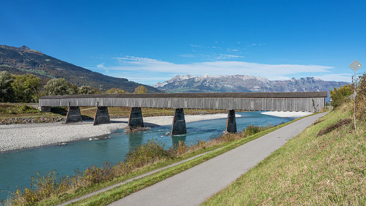
The last wooden bridge on the Rhine
Between Vaduz and Sevelen a covered bridge from 1901, 135 m long, still stands, open only to walkers and cyclists. It's the best way to be right above the river.
the old wooden bridge between Vaduz and Sevelen -
02 Getting there
The Rhine cycle route crosses the country
EuroVelo 15, the Rhine cycle route, runs through Liechtenstein as part of a network of more than 220 km of cycle paths, according to the tourist board.
cycling in Liechtenstein -
03 My tip
Across the water, your phone changes country
Liechtenstein is in the EEA roaming zone and Switzerland isn't. Near the Rhine your phone may pick up a Swiss network, so I'd select the Liechtenstein one manually.
phone and roaming in Liechtenstein
Plenty of people pass through Liechtenstein without going near the Rhine, because it runs along the country’s western edge and visits tend to stick to the village centres. Yet it’s the river that explains the country. It marks the border with Switzerland, decided where villages could stand and for centuries was the biggest threat they faced. I think it deserves a stop, even a short one.
A river that is a border
The Rhine separates Liechtenstein from the Swiss canton of St Gallen for 25 km, along the whole west of the country. This is the Alpine Rhine, formed where the Anterior and Posterior Rhine meet at Reichenau in Graubünden, running about 90 km down to Lake Constance. In total the river is around 1,320 km long before it reaches the North Sea. Here its average flow is 157 m³/s.
It wasn’t always a clear-cut border. According to the Historical Lexicon, until 1342 both banks had the same lords, the counts of Werdenberg-Sargans, and the parish of Bendern took in villages on the far side until the 17th century. The Rhine became a political frontier in the 15th century and, after the Reformation, a religious one too. Where the country sits among its neighbours is shown on the map of Liechtenstein.
Centuries of floods
Before it was tamed, the Rhine was a wide braided river, with gravel islands, side channels and riverside woods. In 1848 it averaged more than 220 m across along the Werdenberg stretch opposite. It shifted course and burst its banks, and villages built dykes that pushed water towards the other bank, sparking centuries of disputes with the Swiss communities across the water.
Two dates stand out. In 1846 the Rhine broke through above Vaduz, flooded more than 1,000 ha and reached the road beneath the castle. And on 25 September 1927 the dyke burst at Schaan, with an estimated flow of 2,700 m³/s. Since 1990 the state has paid for all the flood defences. More key dates are in the history of Liechtenstein.
From ferries to bridges
Until the 19th century the Rhine was crossed by ferry or at fords, and the ferries stopped for good in 1918. Stable bridges only came in 1867-1871, and all were wooden. Only one survives, the 1901 bridge from Vaduz to Sevelen, covered and open to walkers and cyclists only. I think it’s the finest way to get close to the river, and I cover it in detail in the guide to the old Rhine bridge. The other crossings, at Balzers, Schaan, Bendern and Ruggell, are concrete bridges today.
The Lexicon also records a cautionary tale about meddling with a river. Between 1953 and 1972 so much gravel was dug out that the bed dropped by 4 to 5 m, and in 1970 the Schaan to Buchs bridge collapsed when the water undermined a pier. Of the 30 fish species once found, 17 remain.
Where to see it and how to explore
I’d get close in three ways. On foot, crossing the wooden bridge at Vaduz and stopping in the middle. By bike, because EuroVelo 15, the Rhine cycle route, runs through the country as part of a network of more than 220 km of cycle paths; the routes are in my guide to cycling in Liechtenstein. And from above, from the castle path in Vaduz or from Triesenberg, where you see the whole valley and understand why the old villages kept their distance from the river.
The municipality of Vaduz is proud that the Alpine Rhine has white water with plenty of fish, and that its gravel banks and rock armour are breeding grounds for rare birds. Beside it lie the restored streams of the valley floor, such as the Giessen. I haven’t come across an official source describing a waymarked walk along the dyke, so I don’t recommend it as a route.
Crossing into Switzerland
The far bank is Switzerland, with no fixed check, because the two countries have been in a customs union since 1924 and are both in Schengen. Your phone is the one thing to watch, because EEA roaming rules cover this bank but not the far one, and UK networks price the two separately. Right by the water the handset may jump to a Swiss mast, so I’d pick the network by hand; details on my page about phones and roaming in Liechtenstein.
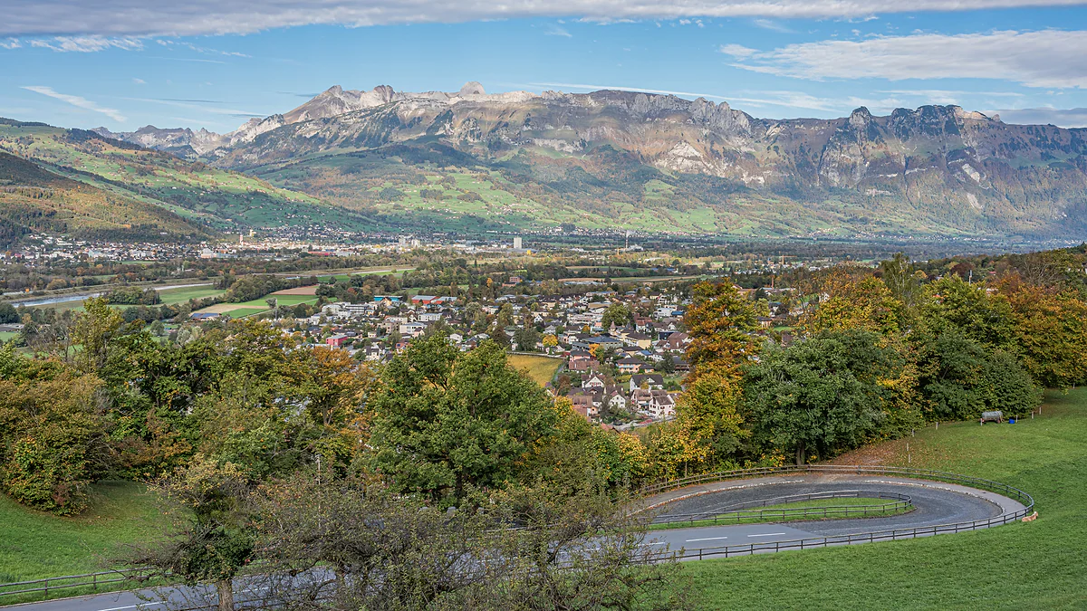
The Rhine valley seen from Vaduz Castle, with the town among autumn trees and the Swiss mountains on the horizon.
Crossing the Rhine from Liechtenstein
| Crossing | To | What's there today |
|---|---|---|
| Balzers | Trübbach | 1967-1968 concrete bridge and a 1975 footbridge |
| Vaduz | Sevelen | 1901 wooden bridge (walkers and bikes) and a 1975 bridge |
| Schaan | Buchs | 1975-1977 bridge, 2009 suspension footbridge and the railway bridge |
| Bendern | Haag | 1963-1964 concrete bridge |
| Ruggell | Sennwald | 1965-1966 concrete bridge |
From the Historical Lexicon (Rheinbrücken entry).
The Rhine in figures
| Fact | Figure |
|---|---|
| Total length | About 1,320 km |
| Stretch beside Liechtenstein | 25 km |
| Alpine Rhine, Reichenau to Lake Constance | About 90 km |
| Average flow | 157 m³/s |
| Estimated flow in the 1927 flood | About 2,700 m³/s |
| Fish species | From 30 originally to 17 today |
Historical Lexicon, Rhein entry (as of 2011).
Test yourself
True or false?
0/4 Pick before you peek.
-
Thanks to the Rhine, Liechtenstein has a shore on Lake Constance.
See the answer
False. The Rhine runs along its western border and flows into Lake Constance further north, outside the country. Liechtenstein doesn't touch the lake.
-
Until the 19th century the Rhine was mostly crossed by ferry or at fords.
See the answer
True. The first lasting bridges date from 1867-1871. Before that there were ferries and fords, and the ferry service ended completely in 1918.
-
Gravel extraction lowered the bed of the Rhine by several metres.
See the answer
True. Between 1953 and 1972 gravel extraction lowered the bed by 4 to 5 m; in 1970 it even brought down the Schaan to Buchs bridge.
-
Liechtenstein shares a river border with Austria on the Rhine.
See the answer
False. Along Liechtenstein, the Rhine separates it from Switzerland, specifically the canton of St Gallen. The border with Austria runs overland, to the north and east.
- Stretch of the Rhine beside Liechtenstein
- 25 km
- Average flow of the Alpine Rhine
- 157 m³/s
- Year of the great flood, when the Schaan dyke burst
- 1927
- Year the ferries stopped for good
- 1918
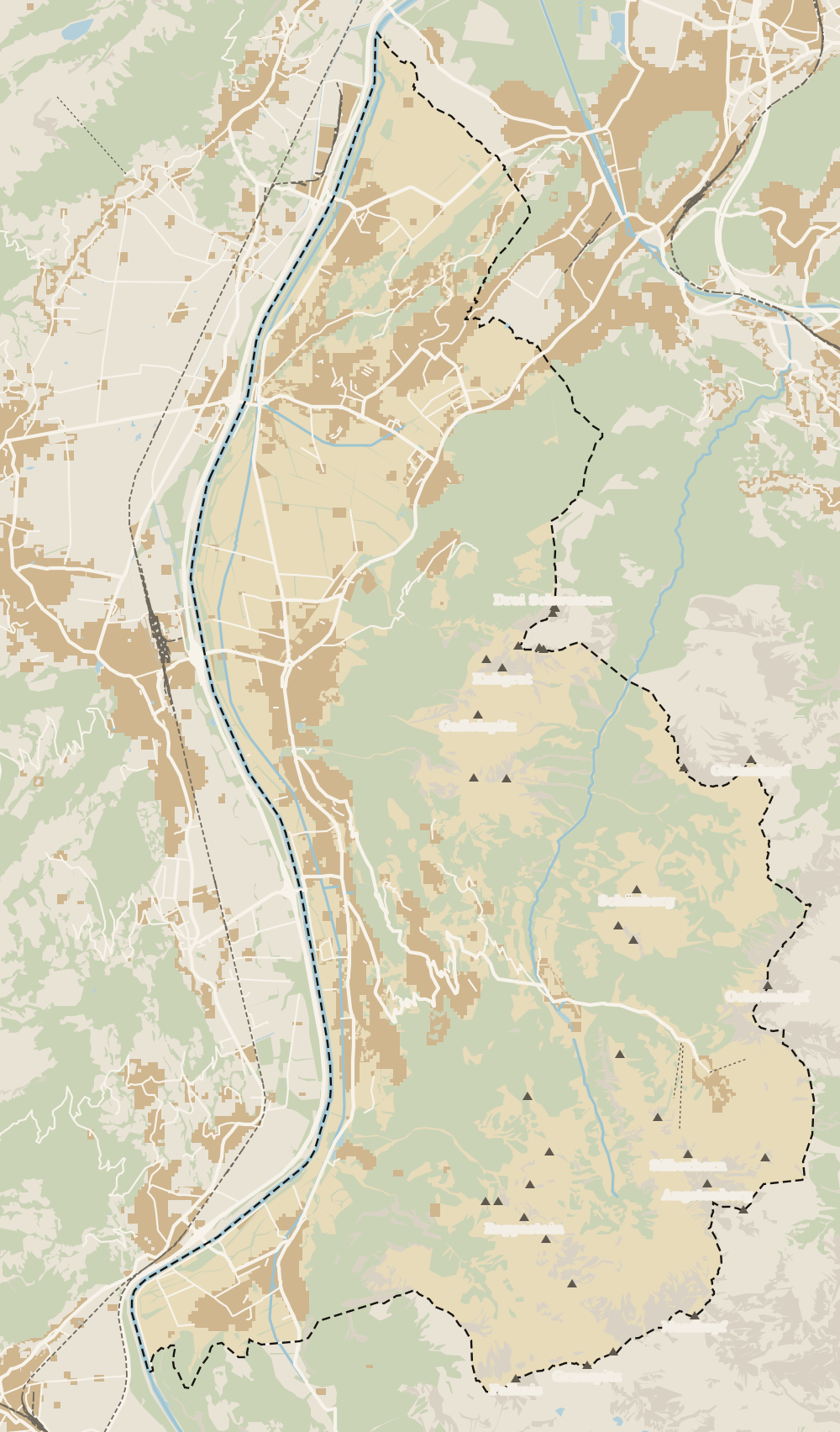
Map
Where The Rhine is
The dashed line is the border: Switzerland across the Rhine, Austria to the north and east. Every number opens its guide.
0 of 168 Liechtenstein guides
Your next stamp
- Borders and customs
- Map
- Old Rhine Bridge
- Getting there
- History
- Two days
- Political system
- Things to do
- One day
- Municipalities
- Oberland
- Unterland
- Vaduz
- Städtle
- Mitteldorf
- Vaduz Castle
- Vaduz Cathedral
- Parliament
- Government Building
- Vaduz Town Hall
- Red House
- Prince's Winery
- Schaan
- Schalun Castle Ruin
- Balzers
- Citytrain
- Triesen
- Triesenberg
- Walser Museum
- Planken
- Gutenberg Castle
- Schaan Roman fort
- Dux
- St Mamertus chapel
- Lawena valley
- Mäls
- DoMuS
- TAK Theatre
- Castles
- Churches and chapels
- Viewpoints
- Mountains
- Museums
- Kunstmuseum
- Mountain huts
- Hilti Art Foundation
- Pfälzerhütte
- Gafadura hut
- National Museum
- Treasure Chamber
- Postage Stamp Museum
- Kunstraum Engländerbau
- Eschen
- Masescha
- Gaflei
- Nendeln
- Mauren
- Silum
- Rotenboden
- Schaanwald
- Gamprin
- Wangerberg
- Bendern
- Steg
- Ruggell
- Samina valley
- Schellenberg Farmhouse Museum
- Cross-country skiing at Steg
- Küefer-Martis-Huus
- Ruggeller Riet
- Schellenberg
- Hinterschellenberg
- Fürstensteig
- Is it a country?
- Liechtenstein Trail
- Malbun
- Schellenberg castles
- Eschnerberg
- Malbun in summer
- Population
- Stage 1: Balzers - Triesenberg
- Lakes
- Sareis
- Size
- Stage 2: Triesenberg - Vaduz
- Malbun Peace Chapel
- Stage 3: Vaduz - Nendeln
- Swimming pools
- Language
- Skiing in Malbun
- Stage 4: Nendeln - Ruggell
- Dialect
- Malbun ski pass
- Stage 5: Ruggell - Schaanwald
- Hotels in Malbun
- Stamps
- Princess Gina Trail
- Hut-to-hut Route 66
- Hiking
- In winter
- Weather
- Airport
- Best time to visit
- In summer
- Events
- With kids
- Zurich to Liechtenstein
- National day
- Sargans to Vaduz
- Christmas
- Feldkirch to Vaduz
- By train
- Traditions
- Carnival
- Getting around
- Buses
- Funken Sunday
- Alpine cattle drive
- Driving and vignette
- Parking
- Bike hire
- Cycling
- EU and Schengen
- Entry requirements
- The prince
- The princely house
- The flag
- The coat of arms
- The national anthem
- Second World War
- No army
- Facts
- Why so rich?
- Banks and tax haven
- Where to stay
- Hilti
- Hotels in Vaduz
- False teeth
- Hostel and camping
- Rent the country?
- Where to eat
- Restaurants in Vaduz
- Swiss invasions
- Bars and nightlife
- Food
- Käsknöpfle
- Wine
- Casinos
- Adventure Pass
- Rainy days
- Guided tours
- Tourist office
- Day trips
- Passport stamp
- Music festivals
- Phone and roaming
- Currency and payments
- Prices and budget
- Tipping
- Plugs and sockets
- Tap water
- Opening hours
- Public holidays
- Safety
- Accessibility
- With a dog
- Shopping and souvenirs
Frequently asked questions
Is Vaduz on the Rhine?
Yes, the Rhine flows just west of the capital and forms the border with Switzerland. Between Vaduz and the Swiss village of Sevelen you can cross on a 1901 wooden bridge, for walkers and cyclists only, or on a 1975 concrete one.
What rivers are there in Liechtenstein?
The main one is the Rhine, on the western border. Inside the country there are streams and channels such as the Binnenkanal, one of the few right-bank tributaries the Rhine still has, and in Vaduz restored streams like the Giessen and the Irkelesbach.
Is the Rhine the border between Liechtenstein and Switzerland?
Yes, along the whole west of the country. The Rhine separates Liechtenstein from the Swiss canton of St Gallen for 25 km. To the south the border with Switzerland runs through the mountains of the canton of Graubünden.
Does the Rhine flood in Liechtenstein?
It did for centuries. In 1846 it flooded more than 1,000 ha and reached the road below the castle in Vaduz, and on 25 September 1927 the dyke burst at Schaan. Today it runs between flood defences along almost the whole stretch.
Can you walk across the Rhine from Vaduz?
Yes, over the covered wooden bridge to Sevelen in Switzerland. It's 135 m long and since 2009-2010 only walkers and cyclists use it. There's no fixed check, as both countries are in Schengen and in a customs union.
By
Tourism graduate with a master’s in Tourism Management and Planning from the University of Málaga, who has travelled across Europe. He writes every guide from official sources and his own judgement.
Published on . Facts checked on .
Sources
Photos: A.Savin (FAL); A.Savin (FAL), via Wikimedia Commons.