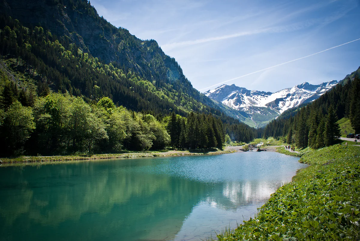
The inner valley behind the Kulm ridge
The Samina valley, the Liechtenstein you can't see from Vaduz
The Samina valley is Liechtenstein's big inner valley, behind the Kulm ridge and shared with Frastanz in Austria. Its upper end holds Steg, the Valüna valley and the Sücka alp; to the north, the Historisches Lexikon describes a state of wilderness found nowhere else in the country. The river drains about 50 km² of mountains.
In 30 seconds
Full read: 3 min
- The Samina valley is Liechtenstein's inner valley, behind the Kulm ridge.
- Its upper end holds Steg, the Valüna valley and the Sücka alp.
- To the north, the lower valley is the country's only wilderness, according to the Lexikon.
- Route 21 reaches Steg in about 25 minutes from Vaduz.
I'd treat the valley as two halves. The top half, from Steg to Valüna, is an easy stroll for anyone; the bottom half, towards Austria, is wild ground the Alpine Club marks as an alpine route, and I'd only go in there with experience.

Before you go
What I would keep in mind
-
01 Most beautiful
The country's only true wilderness
The Historisches Lexikon describes the lower valley as a state of wilderness unique in Liechtenstein, with a free-flowing river and huge debris fans. There's been talk of protecting it since 1970.
-
02 My tip
Start at the Steg reservoir
The path leaves the Steg FL, Tunnel stop, skirts the reservoir and follows the stream towards Valüna. It's the easiest section of the valley and you come back the same way.
Steg and its ring of huts -
03 Getting there
Route 21 to Steg
The Vaduz to Malbun bus goes through the Kulm tunnel and stops at Steg in about 25 minutes. It's the only way into the valley by public transport.
Liechtenstein's buses -
04 Worth the splurge
Climb to the Pfälzerhütte via Valüna
The Liechtenstein Alpine Club gives a route from Steg up the Valüna valley to the Pfälzerhütte of two to three hours, depending on the variant. It turns a stroll into a proper hut walk.
the Pfälzerhütte
What I would book
From Vaduz, Liechtenstein looks like a valley with one hillside. What you can’t see is that behind that hillside lies a whole other valley, the Samina, with its alps, its river and a stretch the Historisches Lexikon describes as the country’s only wilderness. For me it’s the hidden half of Liechtenstein, and it deserves a day.
What it is and where it begins
The Samina valley lies east of the Kulm ridge, behind Triesenberg, and on the Liechtenstein side its floor runs from 950 to 1,300 m. It’s drained by the Samina, which according to the Lexikon collects water from about 50 km² of mountains, runs 12.93 km inside the country and 9.22 km in Austria, and flows into the Ill and from there the Rhine. To the north the valley continues into Frastanz, in the Vorarlberg.
The layout is easy to remember. On the west side are the Sücka, Bargälla and Garsälli alps, belonging to Triesenberg, and the Plankner Garselli forest reserve; on the east side are Vorder- and Mittlervalorsch, belonging to Schaan, and the Zegerberg reserve. South of Steg the valley becomes the Valüna, and the side valleys to the east are the Valorsch and the Malbun. The name Samina is pre-Roman, turns up in 1355 as Samiun, and nobody has yet worked out what it means.
The top half, from Steg to Valüna
This is where nearly everyone starts, and with good reason. Steg, with its ring of huts, sits where the valleys branch, and from the 1947-1948 reservoir a path follows the stream towards Valüna, a broad alpine valley that belongs to Triesen. The Lexikon notes that the governor Josef Schuppler rated Valüna the best alp in the country in 1815, and that today it’s a much-loved spot for summer walking and winter cross-country skiing. It has three grazing tiers, Valünasäss at 1,409 m, Waldboda at 1,557 m and Obersäss at 1,646 m.
On the Kulm side above Steg is the Sücka alp, with its inn at 1,402 m. It was one of the first stops for visitors to the country’s mountains, back in the 1870s, and the Lexikon tells the legend of the Sückacheris, a cheating, gambling herdsman. In winter, the road from the Kulm down to Steg past Sücka has served as a natural toboggan run since 1963.
The bottom half, the wild bit
The northern stretch is a different story. The Lexikon describes it as a state of wilderness unique in Liechtenstein, with the Samina running free and side streams pushing out great fans of debris. For centuries it was used for grazing goats and sheep in the woods, for hunting and for timber, which was floated down the river to Frastanz until 1910. There was even a mine in the Valorsch until the early 17th century.
Since 1970, which the Lexikon calls the International Year of Nature Conservation, there’s been talk of making it a large protected area, and in 1977 an alpine reserve of 1,363 hectares was proposed. It never became a national park, but there’s been a plant protection area since 1989, the Garselli-Zegerberg forest reserve since 2000 and a winter quiet zone for wildlife since 2014, below the Bargälla alp. On the Austrian side, the mountain pine woods have been Natura 2000 sites since 2002. Together, the Lexikon says, they’d add up to around 2,500 hectares of cross-border wilderness.
Can you walk through it?
Yes, but with care. According to the Lexikon, the lower valley is only opened up by the Drei Schwestern path along the top and the Samina trail along the bottom, which runs to Amerlügen in Frastanz. The Liechtenstein Alpine Club lists Steg-Saminatal-Amerlügen among its popular routes but grades it as an alpine path, so it’s no Sunday stroll. The upper valley, on the other hand, is for everyone. And if you want to turn it into a hut walk, the Alpine Club gives a route from Steg to the Pfälzerhütte up the Valüna valley of two to three hours.
Getting there
Public transport has one way in, the Steg FL, Tunnel stop on bus 21, about 25 minutes from the capital with one bus an hour. In winter the same stop is your starting point for cross-country skiing at Steg. I’d carry water and food. A 2024 tourist board page mentioned a restaurant at the Valünahütte, open from June to October depending on the weather, but I haven’t got a current source to confirm it.
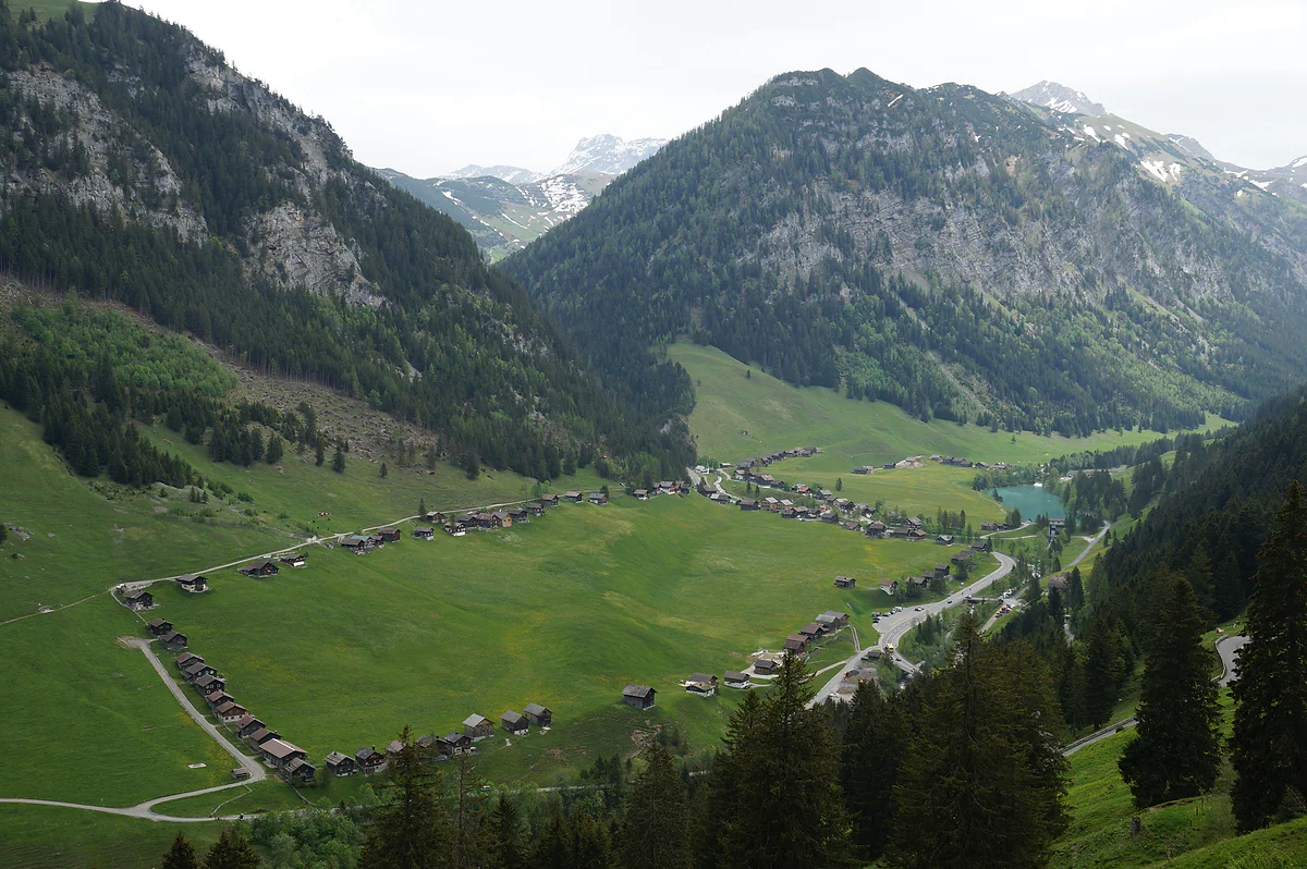
The Steg valley with its rows of wooden huts on the meadow, the reservoir at the far end and the mountains all around.
The Samina valley in numbers
| Fact | Figure | Source |
|---|---|---|
| Valley floor in Liechtenstein | 950-1,300 m | Historisches Lexikon |
| River catchment | About 50 km² | Historisches Lexikon |
| Length of the Samina | 12.93 km in Liechtenstein, 9.22 km in Austria | Historisches Lexikon |
| Steg reservoir | 1,296 m, 3.2 ha | Historisches Lexikon |
| Valüna alp | 498 ha, from 1,409 to 1,646 m | Historisches Lexikon |
| Sücka alp | Inn at 1,402 m | Historisches Lexikon |
Who's who in the valley
| Side | Alps and reserves |
|---|---|
| West | Sücka, Bargälla and Garsälli (Triesenberg); Plankner Garselli forest reserve |
| East | Vorder- and Mittlervalorsch (Schaan); Zegerberg forest reserve |
| South | Valüna valley (an alp belonging to Triesen) |
| Side valleys | Valorsch and Malbun |
From the Historisches Lexikon article «Saminatal», updated on 14 April 2023.
Test yourself
True or false?
0/3 Pick before you peek.
-
The Samina valley lies entirely within Liechtenstein.
See the answer
False. It's shared with Frastanz in Austria's Vorarlberg. The Samina runs 12.93 km in Liechtenstein and 9.22 km in Austria before joining the Ill.
-
Timber was floated down the Samina until the early 20th century.
See the answer
True. According to the Historisches Lexikon, logs were floated down to Frastanz until 1910, using dams that released water to boost the current.
-
The lower Samina valley is a national park.
See the answer
False. It's been discussed since 1970 but never designated. There's a plant protection area from 1989, the Garselli-Zegerberg forest reserve from 2000 and a winter quiet zone for wildlife from 2014.
- Samina catchment
- 50 km²
- Of river inside Liechtenstein
- 12.93 km
- Saminawerk built
- 1947-1949
- Alpine reserve proposed in 1977
- 1,363 ha
Map
Where Samina valley is
The dashed line is the border: Switzerland across the Rhine, Austria to the north and east. Every number opens its guide.
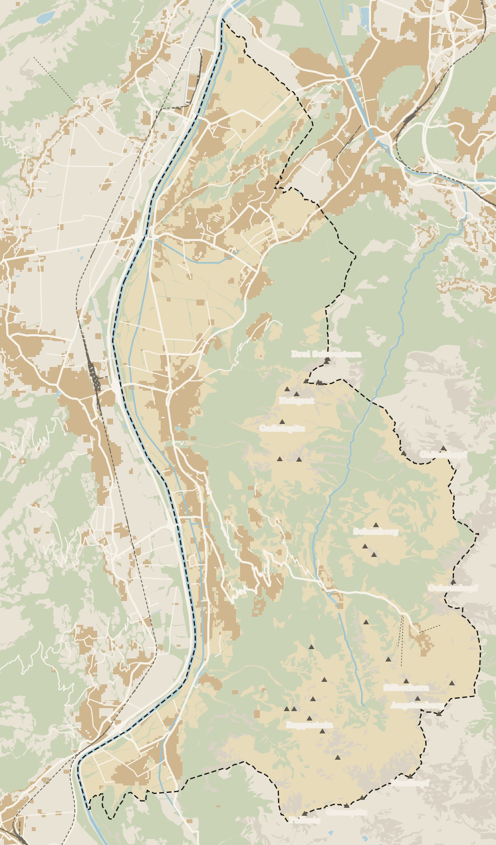 1Triesenberg 2Walser Museum 3Masescha 4Gaflei 5Silum 6Rotenboden 7Wangerberg 8Steg 9Samina valley 10Malbun
 Map data © OpenStreetMap contributors (ODbL)
- 1TriesenbergLargest and highest municipality in the country
- 2Walser MuseumClosed from 12:00 to 15:00
- 3MaseschaTriesenberg hamlet at 1,250 m
- 4GafleiHome of the country's first spa hotel, in 1875
- 5SilumWalser alp between 1,400 and 1,700 m
- 6RotenbodenTriesenberg hamlet, Rotaboda in dialect
- 7WangerbergTriesenberg hamlet, Wangerbärg in dialect
- 8StegTriesenberg summer pasture at about 1,300 m
- 9Samina valleyThe inner valley behind the Kulm ridge
- 10MalbunAt 1,600 m, with an hourly bus from Vaduz
0 of 168 Liechtenstein guides
Your next stamp
- Cross-country skiing at Steg
- Lawena valley
- Malbun
- Two days
- Map
- Things to do
- Feldkirch to Vaduz
- Viewpoints
- One day
- Municipalities
- Oberland
- Unterland
- Vaduz
- Städtle
- Mitteldorf
- Vaduz Castle
- Vaduz Cathedral
- Parliament
- Government Building
- Vaduz Town Hall
- Red House
- Prince's Winery
- Old Rhine Bridge
- Schaan
- Schalun Castle Ruin
- Balzers
- Citytrain
- Triesen
- Triesenberg
- Walser Museum
- Planken
- Gutenberg Castle
- The Rhine
- Schaan Roman fort
- Dux
- St Mamertus chapel
- Mäls
- DoMuS
- TAK Theatre
- Castles
- Churches and chapels
- Mountains
- Museums
- Kunstmuseum
- Mountain huts
- Hilti Art Foundation
- Pfälzerhütte
- Gafadura hut
- National Museum
- Treasure Chamber
- Postage Stamp Museum
- Kunstraum Engländerbau
- Eschen
- Masescha
- Gaflei
- Nendeln
- Mauren
- Silum
- Rotenboden
- Schaanwald
- Gamprin
- Wangerberg
- Bendern
- Steg
- Ruggell
- Schellenberg Farmhouse Museum
- Küefer-Martis-Huus
- Ruggeller Riet
- Schellenberg
- Hinterschellenberg
- Fürstensteig
- Is it a country?
- Liechtenstein Trail
- Schellenberg castles
- Eschnerberg
- Malbun in summer
- Population
- Stage 1: Balzers - Triesenberg
- Lakes
- Sareis
- Size
- Stage 2: Triesenberg - Vaduz
- Malbun Peace Chapel
- Political system
- Stage 3: Vaduz - Nendeln
- Swimming pools
- Language
- Skiing in Malbun
- Stage 4: Nendeln - Ruggell
- Dialect
- Malbun ski pass
- Stage 5: Ruggell - Schaanwald
- Hotels in Malbun
- Stamps
- Princess Gina Trail
- Hut-to-hut Route 66
- Hiking
- Getting there
- In winter
- Weather
- Airport
- Best time to visit
- In summer
- Events
- With kids
- Zurich to Liechtenstein
- National day
- Sargans to Vaduz
- Christmas
- By train
- Traditions
- Carnival
- Getting around
- Buses
- Funken Sunday
- Alpine cattle drive
- Driving and vignette
- Parking
- Bike hire
- Cycling
- EU and Schengen
- Entry requirements
- Borders and customs
- The prince
- The princely house
- The flag
- The coat of arms
- The national anthem
- History
- Second World War
- No army
- Facts
- Why so rich?
- Banks and tax haven
- Where to stay
- Hilti
- Hotels in Vaduz
- False teeth
- Hostel and camping
- Rent the country?
- Where to eat
- Restaurants in Vaduz
- Swiss invasions
- Bars and nightlife
- Food
- Käsknöpfle
- Wine
- Casinos
- Adventure Pass
- Rainy days
- Guided tours
- Tourist office
- Day trips
- Passport stamp
- Music festivals
- Phone and roaming
- Currency and payments
- Prices and budget
- Tipping
- Plugs and sockets
- Tap water
- Opening hours
- Public holidays
- Safety
- Accessibility
- With a dog
- Shopping and souvenirs
Frequently asked questions
Where is the Samina valley?
East of the Kulm ridge, behind Triesenberg. It's the inner valley of Liechtenstein's mountains and runs north to Frastanz in Austria's Vorarlberg.
How do I get to the Samina valley?
Take LIEmobil route 21 from Vaduz, Post to Steg FL, Tunnel, about 25 minutes. By car, drive up through Triesenberg and the Gnalp-Steg tunnel.
What is there to see in the Samina valley?
The ring of huts at Steg, the reservoir, the Valüna valley and the Sücka alp with its inn. Further down, towards Austria, the wild stretch of river, strictly for experienced walkers.
Can you walk through the Samina valley to Austria?
There's a path from Steg down the valley to Amerlügen in Frastanz. The Historisches Lexikon calls it a popular trail, but the Liechtenstein Alpine Club grades it as an alpine route, so it's not a gentle stroll.
What is the Saminawerk?
The hydroelectric scheme on the Samina, built in 1947-1949 and the country's largest power station according to the Historisches Lexikon. Its reservoir is at Steg and the water runs through tunnels down to Vaduz.
Can you fish in the Samina?
The Lexikon says brown trout fishing still goes on in the river and that you can fish the Steg reservoir through the Fischereiverein Liechtenstein. You'll need the appropriate permit.
By
Tourism graduate with a master’s in Tourism Management and Planning from the University of Málaga, who has travelled across Europe. He writes every guide from official sources and his own judgement.
Published on . Facts checked on .
Sources
Photos: Clemens v. Vogelsang from Liechtenstein (CC BY 2.0); albinfo (CC0), via Wikimedia Commons.