Between Switzerland and Austria, 115 km from Zurich
Where Liechtenstein is, on the map and on the ground
Liechtenstein is in central Europe, in the Alps, between Switzerland to the west and south and Austria to the north and east. The Rhine forms most of its Swiss border, and it doesn't touch Germany. Zurich is 115 km away and the nearest airports are Altenrhein and Friedrichshafen. Below is my plan of the whole country, with every sight marked.
In 30 seconds
Full read: 3 min
- Liechtenstein is in the Alps, in the Rhine valley, between Switzerland (west and south) and Austria (north and east).
- It doesn't border Germany; its border runs 41.3 km with Switzerland and 36.6 km with Austria.
- Zurich is 115 km away; Altenrhein 50 km and Friedrichshafen 85 km.
- You arrive by bus from the stations at Sargans, Buchs or Feldkirch.
I'd picture it in three strips. On the left, the Rhine and the flat valley floor with Vaduz, Schaan and almost every village; in the middle, the slopes of Triesenberg; and on the right, behind the ridge, the Samina valley with Steg and Malbun. The north, the Unterland, is a flatter story of its own.

Before you go
What I would keep in mind
-
01 Getting there
Three gateway stations, none of them inside
The tourist board sends you onto LIEmobil buses at Sargans and Buchs stations in Switzerland and Feldkirch in Austria. All three sit just across the border.
how to get to Liechtenstein -
02 My tip
Your phone knows where the Rhine is
Liechtenstein is in the EEA and Switzerland isn't. Swiss masts begin on the far bank, so near the river I'd select the local network by hand, especially on a UK plan.
phone and roaming in Liechtenstein -
03 Most beautiful
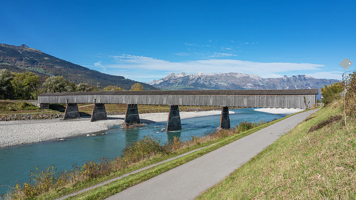
Cross the Rhine on foot over a 1901 bridge
The covered wooden bridge between Vaduz and Sevelen is the last of its kind on the Rhine. It's the loveliest way I know to walk from one country into another.
the old wooden bridge between Vaduz and Sevelen -
04 Getting there
Two motorway exits, one per country
From Switzerland, the A13 to exit 9, Sevelen/Vaduz. From Austria, the A14 to exit 41, Feldkirch-Frastanz, then through Schaanwald. Both routes need a vignette.
driving in Liechtenstein and the vignette
What I would book
To find Liechtenstein on a map of Europe, head for the corner where Switzerland meets Austria, in the Alps, and squint. It’s a narrow strip on the right bank of the Rhine, with mountains stacked behind it. Here I place it among its neighbours, give you the distances that matter for getting there and show a plan of the whole country, marking every place I write about in the guide.
Where is Liechtenstein?
In central Europe, right inside the Alpine arc, in the valley of the Rhine. The river flows from south to north and leaves Liechtenstein on its right, eastern bank, with Switzerland opposite. According to the Office of Statistics, the country’s extreme coordinates run from 47° 02’ 58’’ north at the southern tip to 47° 16’ 14’’ at the northern one, and from 9° 28’ 18’’ east to 9° 38’ 08’’.
In more useful terms, Liechtenstein lies south-east of Lake Constance, east of Zurich and west of Innsbruck. For me, though, the practical reference is closer to home. Feldkirch, in Austria, is pressed against its northern border, while Sargans and Buchs, in Switzerland, face it across the river.
Its neighbours, stretch by stretch
Liechtenstein borders only two countries. With Switzerland it shares 41.3 km, alongside the canton of St. Gallen to the west, following the Rhine, and Graubünden to the south, up in the mountains. With Austria it shares 36.6 km, all of it with Vorarlberg, to the north and east. It doesn’t touch Germany, whatever plenty of people assume. How much country fits inside those borders is in how big Liechtenstein is.
There’s been no customs border with Switzerland since 1924, so crossing the Rhine feels like crossing a street. Austria is a different matter, which I explain on Liechtenstein’s borders and customs. Why a country like this survives between two much larger neighbours is the subject of is Liechtenstein a country?.
How to read my plan of the country
The plan on this page covers the whole of Liechtenstein, with the Swiss bank of the Rhine and Feldkirch at its edge. I built it from OpenStreetMap, with forest, rock, built-up areas, roads, the railway line, the Malbun lifts and every peak above 1,900 metres, and each dot is a sight with its own page.
To read it, think in strips. In the west, beside the Rhine, is the valley floor with almost every village, from Balzers and Gutenberg Castle in the south through Triesen, Vaduz and Schaan. Above it rise the slopes of Triesenberg, home of the Walser. Beyond the ridge, to the east, is the Samina valley with Steg and Malbun, invisible from the valley floor. And to the north, set apart by the Riet wetlands, is the Unterland, with the Eschnerberg and its five villages. That line between the southern valley and the Unterland isn’t just geography, because it also divides the country’s two historic regions, which still vote as separate constituencies today. The full list with its figures is on the municipalities of Liechtenstein.
How far it is from everything
Liechtenstein has no airport. The nearest big one is Zurich, 115 km away, and by public transport it takes 1 h 40 min to 2 h, by train to Sargans and bus to Vaduz. There are two smaller ones, Altenrhein in Switzerland, 50 km away, and Friedrichshafen in Germany, 85 km away. Which to choose depending on where you fly from is covered in the nearest airport to Liechtenstein.
By car, the tourist board reckons on about 45 minutes from St. Gallen, around an hour from Zurich on the A3 and A13, two and a half hours from Innsbruck and about three from Munich. From the UK, I’d simply fly into Zurich and carry on overland, because the train and bus connection from the airport is straightforward and needs no car at all.
Where you actually cross in
By road there are two main ways in. From Switzerland, take the A13 motorway to exit 9, Sevelen/Vaduz, and cross the bridge over the Rhine. From Austria, the A14 to exit 41, Feldkirch-Frastanz, then through Schaanwald to Vaduz. By rail you won’t reach any mainline station in the country, so the usual move is to get off at Sargans, Buchs or Feldkirch and continue on the LIEmobil bus, which serves all three.
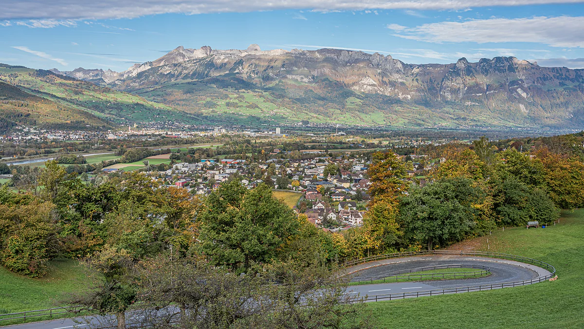
The Rhine valley seen from Vaduz Castle, with the town among autumn trees and the Swiss mountains on the horizon.
How far Liechtenstein is from everything
| From | Distance or time | How |
|---|---|---|
| Zurich airport | 115 km; 1 h 40 min to 2 h | Train to Sargans, then LIEmobil bus |
| Altenrhein airport | 50 km | Regional airport in Switzerland |
| Friedrichshafen airport | 85 km | In Germany |
| St. Gallen | About 45 minutes | By car on the A13 |
| Innsbruck | About 2 h 30 min | By car |
| Munich | About 3 hours | By car on the A96 and A14 |
| Feldkirch (Austria) | 45 minutes to Vaduz | Bus 11, direct |
Distances and driving times from the tourist board (copy of 28-07-2026). Public transport times from the open Swiss timetable for a Tuesday in October 2026.
The country's extreme points
| Extreme | Coordinate | What's nearby |
|---|---|---|
| North | 47° 16' 14'' | Ruggeller Riet and Ruggell |
| South | 47° 02' 58'' | The Grauspitz and Naafkopf massif |
| West | 9° 28' 18'' | The Rhine bank by Balzers |
| East | 9° 38' 08'' | Mountains above Malbun, on the Austrian border |
Coordinates from the Office of Statistics, Liechtenstein in Zahlen 2026, p. 4. The right-hand column is my reading of the plan.
Test yourself
True or false?
0/3 Pick before you peek.
-
Liechtenstein borders Germany.
See the answer
False. Its only neighbours are Switzerland and Austria. Austria's Vorarlberg lies between Liechtenstein and Germany.
-
The Rhine forms the border between Liechtenstein and Switzerland.
See the answer
True. The river runs down the west of the country, separating its villages from Swiss towns opposite such as Sevelen and Buchs. The wooden bridge at Vaduz crosses it towards Sevelen.
-
The border with Austria is longer than the border with Switzerland.
See the answer
False. The Swiss border is 41.3 km and the Austrian one 36.6 km, according to the Office of Statistics.
- Neighbouring countries, Switzerland and Austria
- 2
- Total length of the border
- 77.9 km
- Distance to Zurich airport
- 115 km
- Municipalities on the plan
- 11
Map
All 11 municipalities, from the Rhine to Malbun
The dashed line is the border: Switzerland across the Rhine, Austria to the north and east. Every number opens its guide.
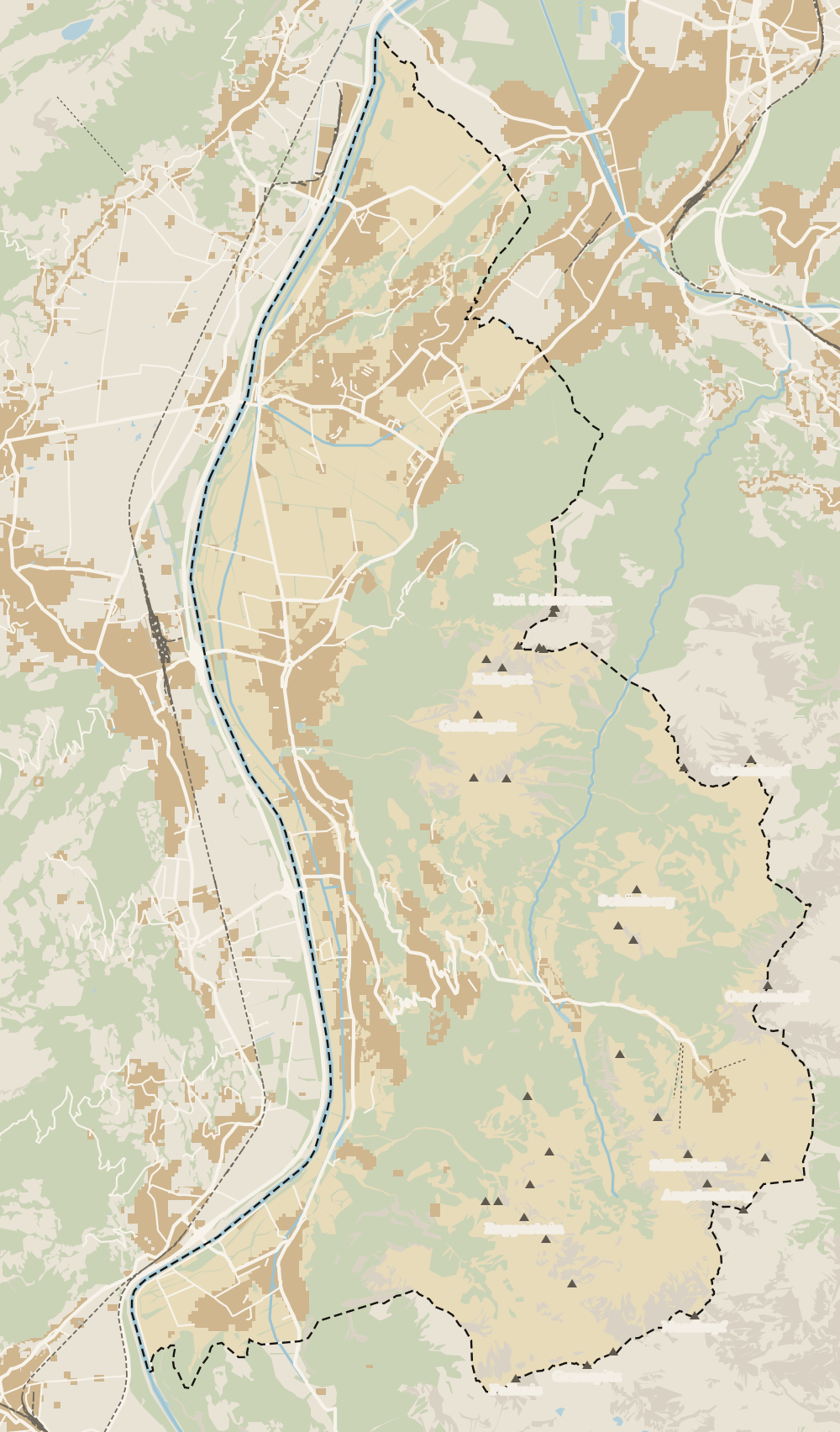 1Vaduz 2Städtle 3Mitteldorf 4Schaan 5Balzers 6Triesen 7Triesenberg 8Planken 9Mäls 10Eschen 11Masescha 12Gaflei 13Nendeln 14Mauren 15Silum 16Rotenboden 17Schaanwald 18Gamprin 19Wangerberg 20Bendern 21Steg 22Ruggell 23Schellenberg 24Hinterschellenberg 25Malbun
 Map data © OpenStreetMap contributors (ODbL)
- 1VaduzA capital since 1719, home to 6,108 people
- 2StädtleCar-free since 28 June 2004
- 3MitteldorfVineyards protected until 2081
- 4Schaan6,294 residents, 186 more than Vaduz
- 5BalzersThe southernmost municipality
- 6TriesenThe highest peak belongs to Triesen too
- 7TriesenbergLargest and highest municipality in the country
- 8Planken499 residents at 786 metres
- 9MälsOlder than Balzers, say the locals
- 10EschenThe Unterland's most populous municipality
- 11MaseschaTriesenberg hamlet at 1,250 m
- 12GafleiHome of the country's first spa hotel, in 1875
- 13NendelnEschen's hamlet below the Drei Schwestern
- 14MaurenLiechtenstein's most densely populated municipality
- 15SilumWalser alp between 1,400 and 1,700 m
- 16RotenbodenTriesenberg hamlet, Rotaboda in dialect
- 17SchaanwaldMauren's hamlet on the Austrian border
- 18GamprinThe village with the bathing lake
- 19WangerbergTriesenberg hamlet, Wangerbärg in dialect
- 20BendernGamprin's hamlet above the Rhine
- 21StegTriesenberg summer pasture at about 1,300 m
- 22RuggellThe country's northernmost municipality
- 23SchellenbergThe country's smallest municipality
- 24HinterschellenbergSchellenberg's hamlet on the Austrian border
- 25MalbunAt 1,600 m, with an hourly bus from Vaduz
0 of 168 Liechtenstein guides
Your next stamp
- The Rhine
- Borders and customs
- Size
- Getting there
- Is it a country?
- Hiking
- Getting around
- Things to do
- One day
- Two days
- Municipalities
- Oberland
- Unterland
- Vaduz
- Städtle
- Mitteldorf
- Vaduz Castle
- Vaduz Cathedral
- Parliament
- Government Building
- Vaduz Town Hall
- Red House
- Prince's Winery
- Old Rhine Bridge
- Schaan
- Schalun Castle Ruin
- Balzers
- Citytrain
- Triesen
- Triesenberg
- Walser Museum
- Planken
- Gutenberg Castle
- Schaan Roman fort
- Dux
- St Mamertus chapel
- Lawena valley
- Mäls
- DoMuS
- TAK Theatre
- Castles
- Churches and chapels
- Viewpoints
- Mountains
- Museums
- Kunstmuseum
- Mountain huts
- Hilti Art Foundation
- Pfälzerhütte
- Gafadura hut
- National Museum
- Treasure Chamber
- Postage Stamp Museum
- Kunstraum Engländerbau
- Eschen
- Masescha
- Gaflei
- Nendeln
- Mauren
- Silum
- Rotenboden
- Schaanwald
- Gamprin
- Wangerberg
- Bendern
- Steg
- Ruggell
- Samina valley
- Schellenberg Farmhouse Museum
- Cross-country skiing at Steg
- Küefer-Martis-Huus
- Ruggeller Riet
- Schellenberg
- Hinterschellenberg
- Fürstensteig
- Liechtenstein Trail
- Malbun
- Schellenberg castles
- Eschnerberg
- Malbun in summer
- Population
- Stage 1: Balzers - Triesenberg
- Lakes
- Sareis
- Stage 2: Triesenberg - Vaduz
- Malbun Peace Chapel
- Political system
- Stage 3: Vaduz - Nendeln
- Swimming pools
- Language
- Skiing in Malbun
- Stage 4: Nendeln - Ruggell
- Dialect
- Malbun ski pass
- Stage 5: Ruggell - Schaanwald
- Hotels in Malbun
- Stamps
- Princess Gina Trail
- Hut-to-hut Route 66
- In winter
- Weather
- Airport
- Best time to visit
- In summer
- Events
- With kids
- Zurich to Liechtenstein
- National day
- Sargans to Vaduz
- Christmas
- Feldkirch to Vaduz
- By train
- Traditions
- Carnival
- Buses
- Funken Sunday
- Alpine cattle drive
- Driving and vignette
- Parking
- Bike hire
- Cycling
- EU and Schengen
- Entry requirements
- The prince
- The princely house
- The flag
- The coat of arms
- The national anthem
- History
- Second World War
- No army
- Facts
- Why so rich?
- Banks and tax haven
- Where to stay
- Hilti
- Hotels in Vaduz
- False teeth
- Hostel and camping
- Rent the country?
- Where to eat
- Restaurants in Vaduz
- Swiss invasions
- Bars and nightlife
- Food
- Käsknöpfle
- Wine
- Casinos
- Adventure Pass
- Rainy days
- Guided tours
- Tourist office
- Day trips
- Passport stamp
- Music festivals
- Phone and roaming
- Currency and payments
- Prices and budget
- Tipping
- Plugs and sockets
- Tap water
- Opening hours
- Public holidays
- Safety
- Accessibility
- With a dog
- Shopping and souvenirs
Frequently asked questions
Where is Liechtenstein located?
In central Europe, in the Alps, in the Rhine valley. Switzerland lies to the west and south and Austria to the north and east. The capital, Vaduz, is 115 km from Zurich airport.
Which countries border Liechtenstein?
Just two. Switzerland, with 41.3 km of border shared with the cantons of St. Gallen and Graubünden, and Austria, with 36.6 km, all of it with the state of Vorarlberg, according to the Office of Statistics.
Is Liechtenstein in Europe?
Yes, right in the middle of the continent between Switzerland and Austria. It belongs to the European Economic Area and Schengen, though not to the European Union.
Does Germany border Liechtenstein?
No. Austria's Vorarlberg sits between Liechtenstein and Germany. The nearest German airport, Friedrichshafen, is 85 km away.
What's the nearest big city to Liechtenstein?
Zurich, 115 km away, is the usual reference for flying in. Closer at hand are Feldkirch in Austria, right on the northern border, and St. Gallen, about 45 minutes by car.
Where is the capital, Vaduz, on the map?
In the middle of the country, on the right bank of the Rhine, at the foot of the slope where the Prince's castle stands. Schaan adjoins it to the north.
By
Tourism graduate with a master’s in Tourism Management and Planning from the University of Málaga, who has travelled across Europe. He writes every guide from official sources and his own judgement.
Published on . Facts checked on .
Sources
Photos: A.Savin (FAL); A.Savin (FAL), via Wikimedia Commons.