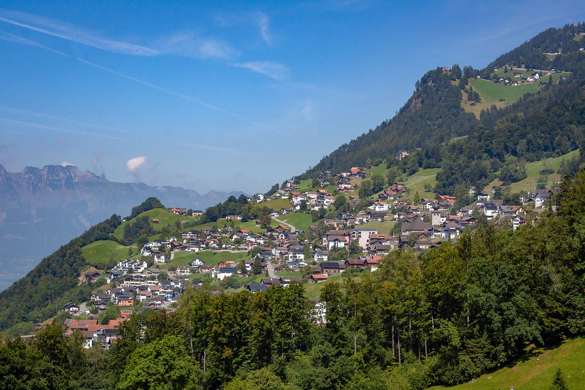
Triesenberg hamlet, Rotaboda in dialect
Rotenboden, the Walser hamlet on the way to Gaflei
Rotenboden, Rotaboda in the Walser dialect, is one of Triesenberg's hamlets on the hillside above Vaduz, below Masescha and on the road up to Gaflei. It already appears on a map of 1756, had the municipality's first recorded inn from 1767, and today bus 22 passes through about two minutes from the village centre.
In 30 seconds
Full read: 3 min
- Rotenboden, Rotaboda in dialect, is a Walser hamlet in Triesenberg.
- It lies below Masescha on the road up to Gaflei.
- It had Triesenberg's first recorded inn, from 1767.
- Bus 22 runs past it about two minutes from the village centre.
Rotenboden isn't a destination in itself, it's a stretch of the walk. I'd pass through it on foot coming down from Masescha to Triesenberg centre, because that's the best way to see how the Walser hamlets are strung across the slope.

Before you go
What I would keep in mind
-
01 Getting there
Bus 22 runs through it
The official timetable has no stop called Rotenboden. The closest to the hamlet's point on OpenStreetMap is Triesenberg, Samina, about 60 m away going by the stops' coordinates, two minutes from the centre.
Liechtenstein's buses -
02 My tip
Walk down from Masescha
The Historisches Lexikon places Masescha directly above Rotenboden. Take the bus up to the chapel and walk down through the hamlets to the centre, all of it downhill.
Masescha and its Walser chapel -
03 Most beautiful
Gaflei, ten minutes further up
From the stops around Rotenboden, the same route 22 carries on to Gaflei, whose tower has what the tourist board calls a spectacular view over Vaduz.
Gaflei, the lookout above Vaduz
What I would book
Rotenboden has no monument and no named viewpoint, and I’m not going to pretend otherwise. It’s a hamlet on the Triesenberg slope that the Gaflei road runs through, and I’ve written it up because it shows so clearly how the Walser spread themselves across this mountainside.
Where it is and what it’s called
Rotenboden lies on the Rhine side of Triesenberg, where, according to the Historisches Lexikon, the Walser hamlets are scattered between 700 and 1,250 m. The Lexikon places it below Masescha, which sits to the east and higher up, on the way to Gaflei.
The name comes in two versions. Official maps say Rotenboden, while the Lexikon, which follows local speech, says Rotaboda. It’s the same story with Wangerberg, the Triesenberg hamlet above Triesen, which the Lexikon spells Wangerbärg, or with Steinort and Steinord, and I go through more examples on my page about Liechtenstein’s dialect. I use the map spelling because it’s the one you’ll see on signs.
More history than it lets on
Almost everything I know about Rotenboden comes from the Lexikon’s article on Triesenberg, because the hamlet doesn’t get one of its own. It crops up there more than once. In the 17th century the municipality was split into five «Viertel» for tax purposes, and Rotaboda was one of them, alongside Masescha, Lavadina, Zehentwis and Gartschind. On Johann Kolleffel’s map of 1756, which already shows hamlets where there had been scattered farms, it’s marked by name.
The church shaped daily life. Until 1768 Rotenboden, Fromahus, Erbi and Prufatscheng didn’t belong to Triesen parish like the rest of the village but to Schaan, so people walked all the way down there for Mass and to bury their dead. Even the tithe went elsewhere, with three quarters of Rotaboda’s and Prufatscheng’s paid to the court chaplaincy in Vaduz.
It also holds a small record. Triesenberg’s first recorded innkeeper was Johannes Hilbe in Rotaboda, documented from 1767, thirteen years before the one by the church in the centre. In the late 19th century the hamlet got its own cooperative dairy, from 1896, when the municipality gave up on every family making its own cheese. There were two more in the village, at Rietli from 1892 and at Steinort from 1912, so each part of the slope had one.
Fromahus, the hamlet between Rotenboden and Vaduz on the 1872 road, has its own footnote. According to the Lexikon it was the last part of the municipality to get electricity, in 1948, when Triesenberg had had power since 1921. That tells you how scattered these hamlets were and what it took to reach them.
The road that put it on the map
In 1872 a road opened from Vaduz to Gnalp via Fromahus and Rotenboden, one of those the Lexikon links to the arrival of tourism. Gnalp, higher up below the Kulm, was among the first Walser settlements on record, in 1355, and was lived in all year round until the late 19th century. Today it’s LIEmobil route 22 that climbs through here, linking Triesenberg centre with Masescha and Gaflei.
A practical note. The official 2026 timetable has no stop called Rotenboden. Going by the stops’ coordinates, the closest to the hamlet’s point on OpenStreetMap is Triesenberg, Samina, about 60 m away, with Almeina and Balischguad close by. The bus takes about two minutes from the centre. On weekdays it leaves the centre once an hour, from 06:29 to 20:59, and like every LIEmobil bus it takes cards or the app but never cash.
How I’d use it
Nobody comes to Rotenboden, you pass through it. My plan would be to ride route 22 up to Gaflei for the view of Vaduz from the tower, walk down to Masescha for the Walser chapel and keep going downhill through Rotenboden to Triesenberg centre and the Walser Museum. It’s all downhill, the hamlets come one after another, and route 21 is waiting at the end to take you back to Vaduz. With more energy I’d start higher still, at Silum, the alp above Masescha, which has no bus stop of its own.
If you want something longer, stage 2 of the Liechtenstein Trail leaves Triesenberg for the capital via the farm at Prufatscheng, which the Lexikon places north of the centre on this same side of the slope. The tourist board sells it on its view over the Rhine valley, and the listed house there has a core dated to 1547-1548.
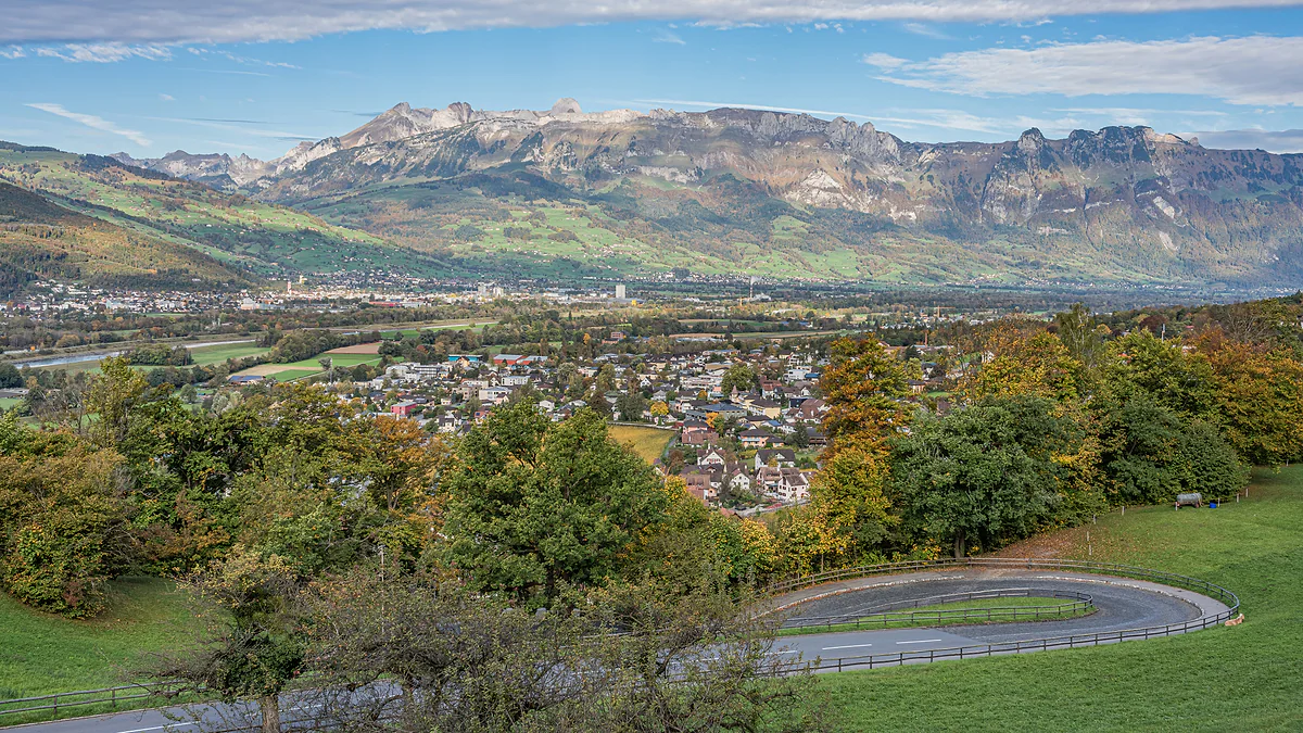
The Rhine valley seen from Vaduz Castle, with the town among autumn trees and the Swiss mountains on the horizon.
Rotenboden in Triesenberg's history
| Year or period | What the Historisches Lexikon says |
|---|---|
| 17th century | One of the municipality's five «Viertel», with Masescha, Lavadina, Zehentwis and Gartschind |
| 1756 | Shown as a hamlet on Kolleffel's map |
| From 1767 | Johannes Hilbe, Triesenberg's first recorded innkeeper |
| Until 1768 | Part of Schaan parish, with Fromahus, Erbi and Prufatscheng |
| 1872 | Road from Vaduz to Gnalp via Fromahus and Rotenboden |
| From 1896 | Cooperative dairy |
Route 22, Triesenberg to Gaflei
| Stop | Minutes from the centre |
|---|---|
| Triesenberg, Dorfzentrum | 0 |
| Triesenberg, Samina | 2 |
| Triesenberg, Balischguad | 4 |
| Masescha, Kapelle | 8 |
| Gaflei, Matu | 12 |
Official 2026 weekday timetable. Samina, Almeina and Balischguad are the stops around Rotenboden.
Test yourself
True or false?
0/3 Pick before you peek.
-
Rotenboden is one of Liechtenstein's municipalities.
See the answer
False. It's a hamlet within Triesenberg. The country has eleven municipalities and Rotenboden isn't one of them.
-
Until 1768 the people of Rotenboden went to Mass in Schaan.
See the answer
True. According to the Historisches Lexikon, Rotaboda, Fromahus, Erbi and Prufatscheng belonged to Schaan parish until Triesenberg got its own in 1768.
-
Triesenberg's first recorded innkeeper ran his tavern in Rotenboden.
See the answer
True. The Lexikon names Johannes Hilbe in Rotaboda, recorded from 1767, as the first known innkeeper in the municipality.
- Appears on Kolleffel's map
- 1756
- Triesenberg's first recorded inn
- 1767
- Vaduz-Rotenboden-Gnalp road
- 1872
- By bus from Triesenberg centre
- 2 min
Map
Where Rotenboden is
The dashed line is the border: Switzerland across the Rhine, Austria to the north and east. Every number opens its guide.
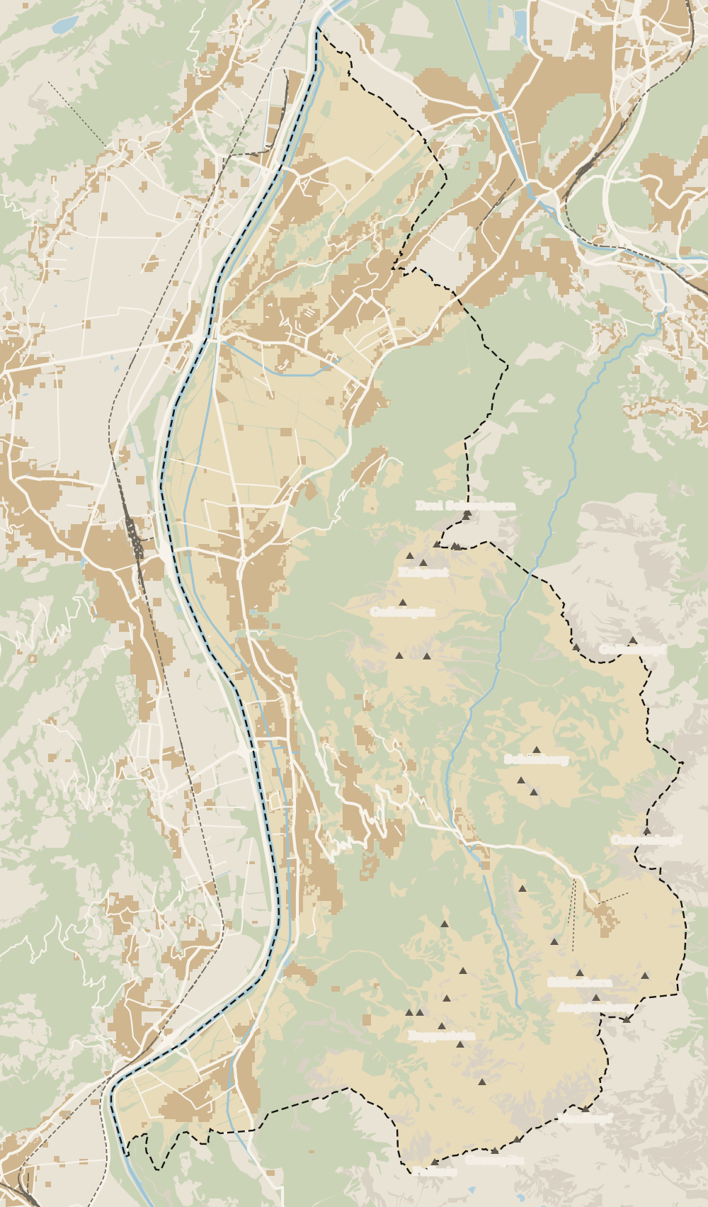 1Triesenberg 2Walser Museum 3Masescha 4Gaflei 5Silum 6Rotenboden 7Wangerberg 8Steg 9Samina valley 10Malbun
 Map data © OpenStreetMap contributors (ODbL)
- 1TriesenbergLargest and highest municipality in the country
- 2Walser MuseumClosed from 12:00 to 15:00
- 3MaseschaTriesenberg hamlet at 1,250 m
- 4GafleiHome of the country's first spa hotel, in 1875
- 5SilumWalser alp between 1,400 and 1,700 m
- 6RotenbodenTriesenberg hamlet, Rotaboda in dialect
- 7WangerbergTriesenberg hamlet, Wangerbärg in dialect
- 8StegTriesenberg summer pasture at about 1,300 m
- 9Samina valleyThe inner valley behind the Kulm ridge
- 10MalbunAt 1,600 m, with an hourly bus from Vaduz
0 of 168 Liechtenstein guides
Your next stamp
- Wangerberg
- Masescha
- Triesenberg
- Gaflei
- Stage 1: Balzers - Triesenberg
- Triesen
- Mountain huts
- Planken
- Things to do
- One day
- Two days
- Municipalities
- Oberland
- Unterland
- Map
- Vaduz
- Städtle
- Mitteldorf
- Vaduz Castle
- Vaduz Cathedral
- Parliament
- Government Building
- Vaduz Town Hall
- Red House
- Prince's Winery
- Old Rhine Bridge
- Schaan
- Schalun Castle Ruin
- Balzers
- Citytrain
- Walser Museum
- Gutenberg Castle
- The Rhine
- Schaan Roman fort
- Dux
- St Mamertus chapel
- Lawena valley
- Mäls
- DoMuS
- TAK Theatre
- Castles
- Churches and chapels
- Viewpoints
- Mountains
- Museums
- Kunstmuseum
- Hilti Art Foundation
- Pfälzerhütte
- Gafadura hut
- National Museum
- Treasure Chamber
- Postage Stamp Museum
- Kunstraum Engländerbau
- Eschen
- Nendeln
- Mauren
- Silum
- Schaanwald
- Gamprin
- Bendern
- Steg
- Ruggell
- Samina valley
- Schellenberg Farmhouse Museum
- Cross-country skiing at Steg
- Küefer-Martis-Huus
- Ruggeller Riet
- Schellenberg
- Hinterschellenberg
- Fürstensteig
- Is it a country?
- Liechtenstein Trail
- Malbun
- Schellenberg castles
- Eschnerberg
- Malbun in summer
- Population
- Lakes
- Sareis
- Size
- Stage 2: Triesenberg - Vaduz
- Malbun Peace Chapel
- Political system
- Stage 3: Vaduz - Nendeln
- Swimming pools
- Language
- Skiing in Malbun
- Stage 4: Nendeln - Ruggell
- Dialect
- Malbun ski pass
- Stage 5: Ruggell - Schaanwald
- Hotels in Malbun
- Stamps
- Princess Gina Trail
- Hut-to-hut Route 66
- Hiking
- Getting there
- In winter
- Weather
- Airport
- Best time to visit
- In summer
- Events
- With kids
- Zurich to Liechtenstein
- National day
- Sargans to Vaduz
- Christmas
- Feldkirch to Vaduz
- By train
- Traditions
- Carnival
- Getting around
- Buses
- Funken Sunday
- Alpine cattle drive
- Driving and vignette
- Parking
- Bike hire
- Cycling
- EU and Schengen
- Entry requirements
- Borders and customs
- The prince
- The princely house
- The flag
- The coat of arms
- The national anthem
- History
- Second World War
- No army
- Facts
- Why so rich?
- Banks and tax haven
- Where to stay
- Hilti
- Hotels in Vaduz
- False teeth
- Hostel and camping
- Rent the country?
- Where to eat
- Restaurants in Vaduz
- Swiss invasions
- Bars and nightlife
- Food
- Käsknöpfle
- Wine
- Casinos
- Adventure Pass
- Rainy days
- Guided tours
- Tourist office
- Day trips
- Passport stamp
- Music festivals
- Phone and roaming
- Currency and payments
- Prices and budget
- Tipping
- Plugs and sockets
- Tap water
- Opening hours
- Public holidays
- Safety
- Accessibility
- With a dog
- Shopping and souvenirs
Frequently asked questions
What is Rotenboden in Liechtenstein?
A hamlet in the municipality of Triesenberg on the hillside above Vaduz, below Masescha and on the road to Gaflei. In the Walser dialect it's called Rotaboda.
How do I get to Rotenboden?
Take route 21 from Vaduz to Triesenberg, then route 22, which reaches the Triesenberg, Samina stop in about two minutes. Going by the stops' coordinates, that's the closest one to the hamlet.
Are Rotenboden and Rotaboda the same place?
Yes. Rotenboden is the standard form on official maps and Rotaboda the dialect form used by the Historisches Lexikon, just like Wangerberg and Wangerbärg or Steinort and Steinord.
Is there anything to see in Rotenboden?
It's a stretch of hillside with houses and meadows rather than a place with monuments. I'd walk through it between Masescha and Triesenberg centre, and take the bus up to Gaflei for the view.
Is there a bus stop called Rotenboden?
Not in the official 2026 timetable. The stops around it are Samina, Almeina and Balischguad on route 22, a few minutes from Triesenberg centre.
By
Tourism graduate with a master’s in Tourism Management and Planning from the University of Málaga, who has travelled across Europe. He writes every guide from official sources and his own judgement.
Published on . Facts checked on .
Sources
Photos: Lucas Kendall (CC BY-SA 4.0); A.Savin (FAL), via Wikimedia Commons.