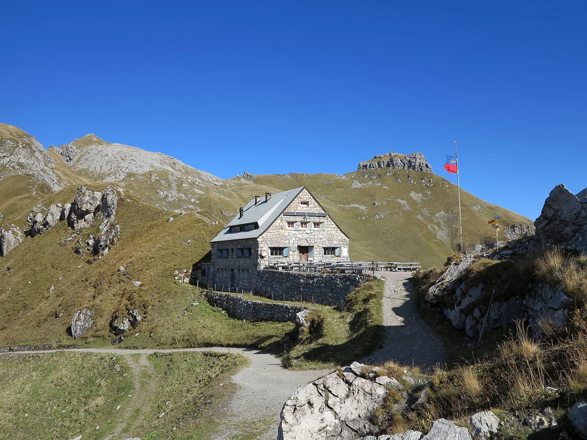
11.9 km, 5 hours and 892 m of climbing
The Princess Gina Trail, the ridge I'd walk if I only had one day
The Princess Gina Trail, or Fürstin-Gina-Weg, is a mountain loop from Malbun that climbs to Sareis, follows the ridge to the 2,359 m Augstenberg, drops to the Pfälzerhütte and returns via the Gritsch alp and the Vaduzer Täli. The tourist board puts it at 11.9 km, about 5 hours and 892 m of ascent and descent. The Sareis chairlift saves you the first climb.
In 30 seconds
Full read: 3 min
- The Princess Gina Trail is an 11.9 km loop from Malbun.
- It climbs via Sareis to the 2,359 m Augstenberg and drops to the Pfälzerhütte.
- Allow about 5 hours of walking and 892 m of ascent.
- The Pfälzerhütte only takes cash.
I'd take the first chairlift, do the ridge in the morning light and have lunch at the Pfälzerhütte. If you've got legs to spare, the detour to the Naafkopf is worth it, but I wouldn't leave it for the afternoon, when cloud builds quickly.

Before you go
What I would keep in mind
-
01 Most beautiful
A flowery ridge with three countries
The tourist board describes a ridge full of flowers with views to the Falknis chain, the Schesaplana massif and the Malbun valley. No walk shows off the country's mountains better.
-
02 Money
Cash only at the hut
The Pfälzerhütte only takes cash, in francs or in euros at the day's rate. Carry notes if you plan to eat or sleep there.
the Pfälzerhütte -
03 To save money
A CHF 11 lift up
The Sareis chairlift takes you to 2,000 m for CHF 11 in summer 2026 and saves the first hour of climbing. It's included in the ALL INCLUSIVE pass.
Sareis chairlift -
04 My tip
The Naafkopf detour
From the Pfälzerhütte you can climb the 2,570 m Naafkopf, where Liechtenstein, Switzerland and Austria meet. The tourist board suggests it as an add-on to this route.
mountains in Liechtenstein
What I would book
My ranking, scored
The stretches of the day, best first
My own scores out of 10 for each stretch, weighing what you see against the effort, based on the official route description.
0 of 4 seen
-
The ridge to the Augstenberg
The heart of the route. Flowers, an open ridge and the Falknis chain and Schesaplana in front of you.
9.5 out of 10
-
The Pfälzerhütte
A 1927-1928 stone hut on the Austrian border. Lunch here is part of the plan, not just a pit stop.
8.8 out of 10
-
Naafkopf detour
Three countries on one 2,570 m summit. Only if you're doing well for time and legs.
8.5 out of 10
-
Down via Gritsch and the Täli
Quieter, with the Malbun valley ahead. The stretch you enjoy on tired legs.
7.6 out of 10
About 7 hours with stops
How I'd do it in a day
- 08:30
Sareis chairlift
First chair from Malbun, Zentrum, which opens at 8:30 on weekdays. If it isn't running, it's an hour's walk up from the Malbun, Jöraboda stop.
- 09:00
Along the Sareiserjoch ridge
The Princess Gina Trail starts along the ridge, with the Falknis chain ahead and the Malbun valley to your right. Flowers in June and July.
- 11:00
Summit of the Augstenberg
The high point of the route at 2,359 m. A good spot for photos and for deciding whether you've the energy for the Naafkopf.
- 12:00
Lunch at the Pfälzerhütte
The Alpine Club hut at 2,108 m on the Bettlerjoch, right on the Austrian border. Cash only.
- 13:30
Down via Gritsch and the Täli
Back via the Gritsch alp and the Vaduzer Täli to Malbun, with the valley ahead all the way. Watch the clock if you want the bus back to Vaduz.
Times are a guide, based on the official opening hours checked for this guide.
If someone asked me for just one walk in Liechtenstein, this would be it. The Princess Gina Trail leaves Malbun, gains the ridge at Sareis, reaches the Augstenberg, stops at the country’s highest hut and returns to the village down another valley. Five hours of walking and you’ve got the country’s mountains in a nutshell. Here’s what it’s like, what it costs and what to bear in mind.
The route step by step
According to the tourist board it’s an 11.9 km loop with 892 metres of ascent and the same again down, between Malbun at 1,598 metres and the Augstenberg at 2,359, taking about five hours of walking. It starts in the village. You go up to Sareis, at 2,000 metres, on the chairlift or on foot in an hour, and from the Sareiserjoch the path follows the ridge southwards. The official page talks of a ridge full of flowers with views to the Falknis chain, the Schesaplana massif and the Malbun valley.
From the summit you drop to the Pfälzerhütte, at 2,108 metres on the Bettlerjoch, at the foot of the Naafkopf and right on the Austrian border. The way back doesn’t retrace your steps. It heads down past the Gritsch alp and through the Vaduzer Täli and ends up back in Malbun, with the valley ahead of you the whole time. The Alpine Club reckons about three hours from Malbun to the hut on this side, less if you ride the chairlift.
The Augstenberg and the Naafkopf detour
The Augstenberg isn’t the country’s high point; that’s the Grauspitz at about 2,600 metres. A 2024 tourist board page described it as the highest summit in Liechtenstein that isn’t on the border, and I like that idea, because everything you see on one side of it belongs to the country.
From the Pfälzerhütte the tourist board suggests a detour to the Naafkopf, 2,570 metres, where Liechtenstein, Switzerland and Austria meet, and says that with luck you’ll spot ibex on the way. It’s a serious extra. I’d only take it on having caught the first chairlift and with a clear sky. There are more of the country’s peaks in Liechtenstein’s mountains.
How hard is it?
It’s a mountain walk, not a stroll. It doesn’t have the fixed rock passages of the Fürstensteig, but it does have nearly 900 metres of climbing and stretches above 2,300. I’d wear walking boots and bring water, a warm layer and food, and I’d check the forecast, because on a ridge a storm gives no warning. The tourist board also reminds walkers that there are cows with calves on the pastures, that you should keep your distance and that dogs belong on a short lead.
Getting there and turning it into two days
Without a car it’s easy. Bus 21 leaves Vaduz, Post once an hour and reaches Malbun, Zentrum in about 30 minutes, right by the chairlift station. The first bus won’t get you there for the first chair, which is why I’d sleep up here the night before. If you drive, the tourist board says you can leave the car free of charge in the P1 to P4 car parks in Malbun.
If you’d rather not rush, spend a night at the Pfälzerhütte and split the walk in two. The tourist board warns that a sleeping-bag liner is compulsory there, you sleep in bunks, there are no showers or wifi, and the three-course vegetarian dinner is served at 18:00, so you need to arrive before 17:00. Next morning you can climb the Naafkopf at first light and wander down to Malbun at your leisure.
The name and the princess
The path is named after Princess Gina, Countess Gina von Wilczek, who married Prince Franz Joseph II in 1943 and is the mother of the current Prince Hans-Adam II. I couldn’t find an official source explaining when or why the path was named after her, so I won’t tell you a story I can’t back up.
Money, food and season
The Pfälzerhütte doesn’t take cards, so bring francs or euros in notes, and half board costs CHF 75 for non-members of an alpine club. The Alpine Club doesn’t publish opening dates, so I won’t guess them. The Sareis chairlift season lasts until 18 October 2026, and the lift company’s homepage says daily if it’s turning. If you want to turn this walk into a three-day traverse, it’s the first stage of the hut-to-hut Route 66.
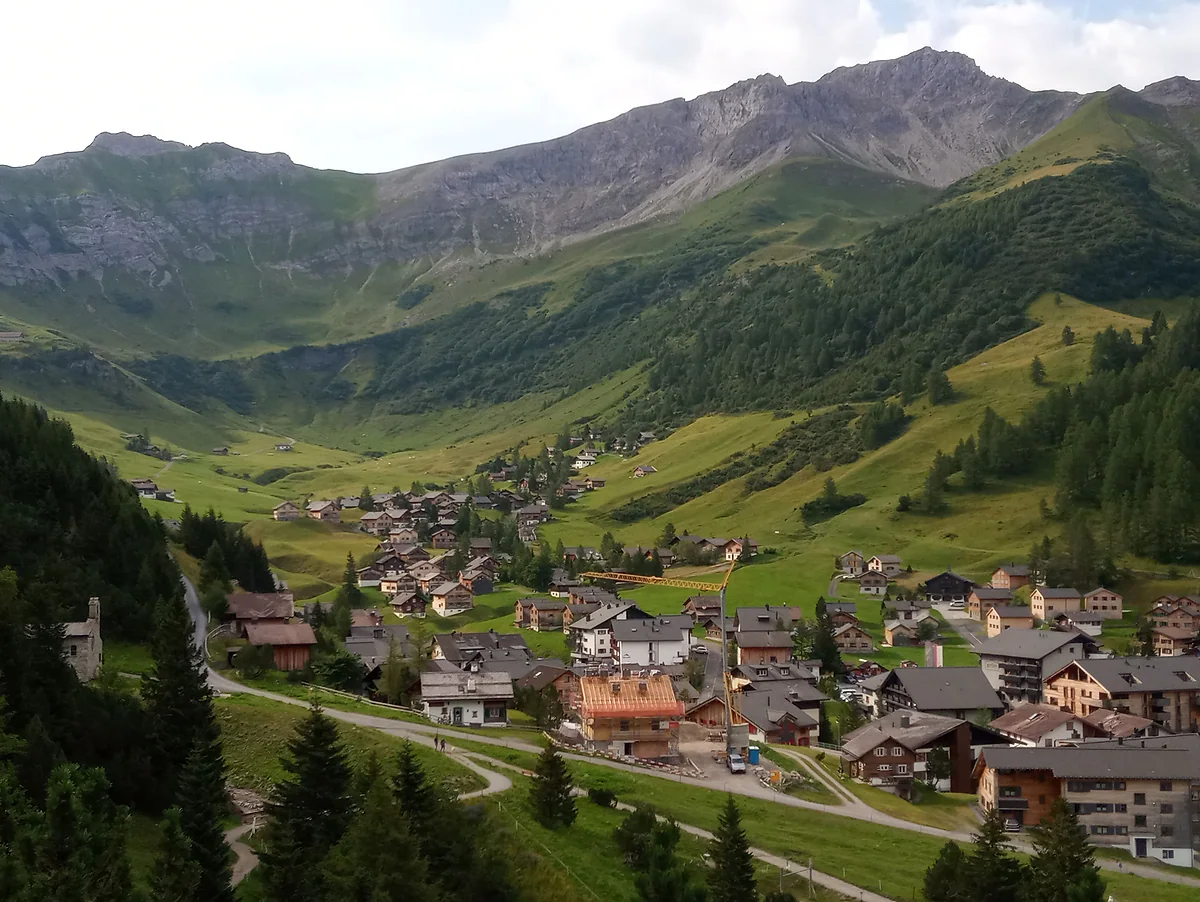
Malbun in summer, with the chalet village on the valley floor, green meadows and rocky peaks above.
The route in numbers
| Fact | Value |
|---|---|
| Length | 11.9 km |
| Walking time | 5 h |
| Total ascent and descent | 892 m each |
| High point | 2,359 m (Augstenberg) |
| Low point | 1,598 m (Malbun) |
| Places to eat | Pfälzerhütte, Restaurant Vögeli and Schlucher-Treff in Malbun |
Figures from the tourist board (archive.org copy of 12 Jun 2026). The Alpine Club reckons about 3 h from Malbun to the Pfälzerhütte this way, less with the chairlift.
Pfälzerhütte prices, 2026
| Service | Alpine club members | Non-members | Children up to 12 |
|---|---|---|---|
| Half board | CHF 68 | CHF 75 | CHF 40 |
| Breakfast only | CHF 38 | CHF 45 | CHF 20 |
Liechtenstein Alpine Club prices. Cash only. The club doesn't publish season opening dates.
Test yourself
True or false?
0/4 Pick before you peek.
-
The Augstenberg is the highest mountain in Liechtenstein.
See the answer
False. The country's high point is the Grauspitz, at about 2,600 m. A 2024 tourist board page called the 2,359 m Augstenberg the highest summit that isn't on the border.
-
The Princess Gina Trail finishes where it starts.
See the answer
True. It's a loop from Malbun back to Malbun via the Gritsch alp and the Vaduzer Täli, according to the tourist board.
-
You can pay by card at the Pfälzerhütte.
See the answer
False. The Liechtenstein Alpine Club says payment at the Pfälzerhütte is cash only, in francs or euros.
-
Princess Gina, who gives the path its name, married Franz Joseph II.
See the answer
True. The Historisches Lexikon records Franz Joseph II's marriage to Countess Gina von Wilczek in 1943.
- Length of the loop
- 11.9 km
- Walking time
- 5 h
- Augstenberg summit
- 2,359 m
- Total ascent
- 892 m
Map
Where Princess Gina Trail is
The dashed line is the border: Switzerland across the Rhine, Austria to the north and east. Every number opens its guide.
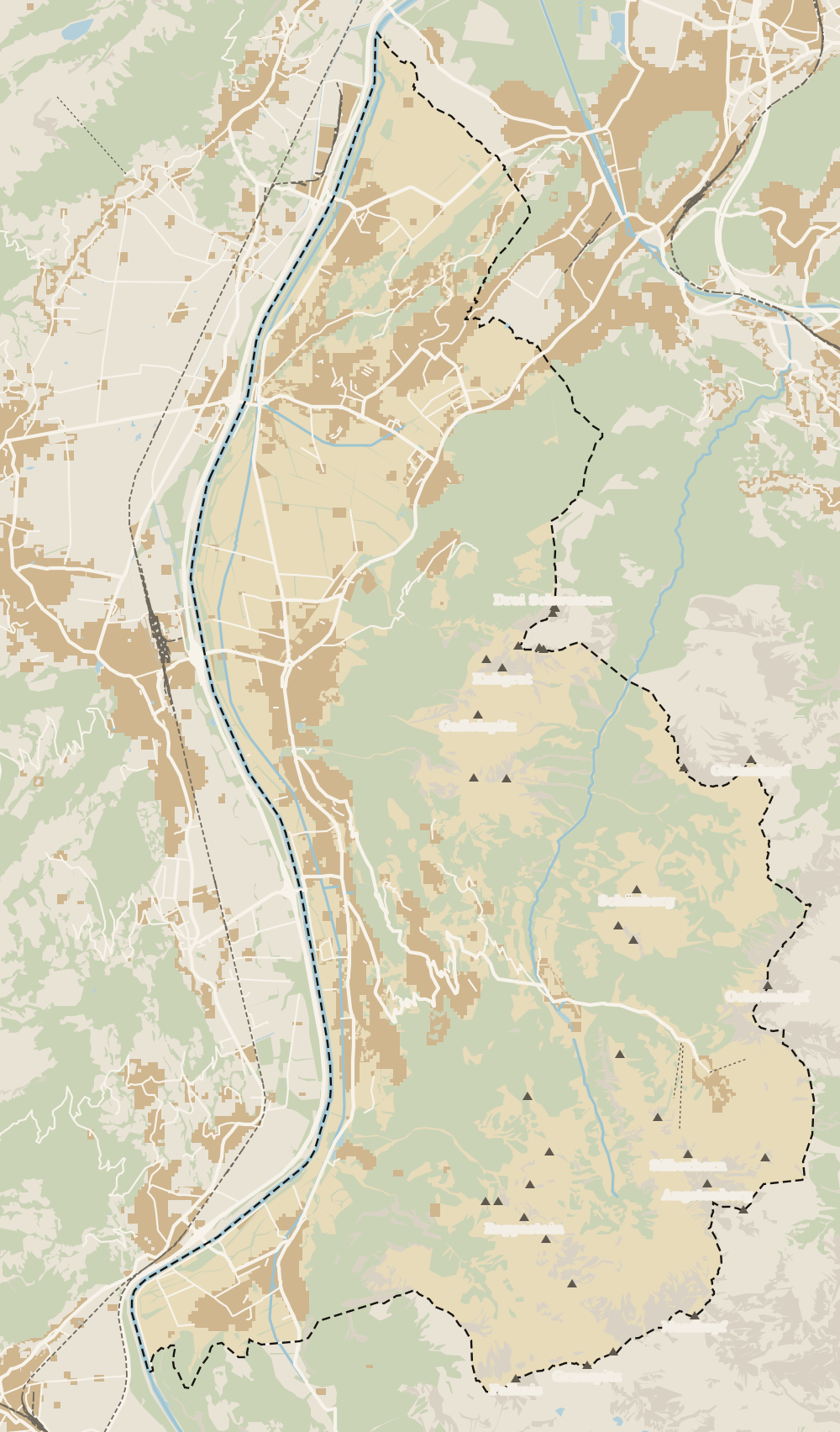 1Fürstensteig 2Liechtenstein Trail 3Princess Gina Trail
 Map data © OpenStreetMap contributors (ODbL)
0 of 168 Liechtenstein guides
Your next stamp
- Hut-to-hut Route 66
- Hiking
- Sareis
- Mountain huts
- Fürstensteig
- Stage 2: Triesenberg - Vaduz
- Pfälzerhütte
- Things to do
- One day
- Two days
- Municipalities
- Oberland
- Unterland
- Map
- Vaduz
- Städtle
- Mitteldorf
- Vaduz Castle
- Vaduz Cathedral
- Parliament
- Government Building
- Vaduz Town Hall
- Red House
- Prince's Winery
- Old Rhine Bridge
- Schaan
- Schalun Castle Ruin
- Balzers
- Citytrain
- Triesen
- Triesenberg
- Walser Museum
- Planken
- Gutenberg Castle
- The Rhine
- Schaan Roman fort
- Dux
- St Mamertus chapel
- Lawena valley
- Mäls
- DoMuS
- TAK Theatre
- Castles
- Churches and chapels
- Viewpoints
- Mountains
- Museums
- Kunstmuseum
- Hilti Art Foundation
- Gafadura hut
- National Museum
- Treasure Chamber
- Postage Stamp Museum
- Kunstraum Engländerbau
- Eschen
- Masescha
- Gaflei
- Nendeln
- Mauren
- Silum
- Rotenboden
- Schaanwald
- Gamprin
- Wangerberg
- Bendern
- Steg
- Ruggell
- Samina valley
- Schellenberg Farmhouse Museum
- Cross-country skiing at Steg
- Küefer-Martis-Huus
- Ruggeller Riet
- Schellenberg
- Hinterschellenberg
- Is it a country?
- Liechtenstein Trail
- Malbun
- Schellenberg castles
- Eschnerberg
- Malbun in summer
- Population
- Stage 1: Balzers - Triesenberg
- Lakes
- Size
- Malbun Peace Chapel
- Political system
- Stage 3: Vaduz - Nendeln
- Swimming pools
- Language
- Skiing in Malbun
- Stage 4: Nendeln - Ruggell
- Dialect
- Malbun ski pass
- Stage 5: Ruggell - Schaanwald
- Hotels in Malbun
- Stamps
- Getting there
- In winter
- Weather
- Airport
- Best time to visit
- In summer
- Events
- With kids
- Zurich to Liechtenstein
- National day
- Sargans to Vaduz
- Christmas
- Feldkirch to Vaduz
- By train
- Traditions
- Carnival
- Getting around
- Buses
- Funken Sunday
- Alpine cattle drive
- Driving and vignette
- Parking
- Bike hire
- Cycling
- EU and Schengen
- Entry requirements
- Borders and customs
- The prince
- The princely house
- The flag
- The coat of arms
- The national anthem
- History
- Second World War
- No army
- Facts
- Why so rich?
- Banks and tax haven
- Where to stay
- Hilti
- Hotels in Vaduz
- False teeth
- Hostel and camping
- Rent the country?
- Where to eat
- Restaurants in Vaduz
- Swiss invasions
- Bars and nightlife
- Food
- Käsknöpfle
- Wine
- Casinos
- Adventure Pass
- Rainy days
- Guided tours
- Tourist office
- Day trips
- Passport stamp
- Music festivals
- Phone and roaming
- Currency and payments
- Prices and budget
- Tipping
- Plugs and sockets
- Tap water
- Opening hours
- Public holidays
- Safety
- Accessibility
- With a dog
- Shopping and souvenirs
Frequently asked questions
How long does the Princess Gina Trail take?
The tourist board gives 5 hours of walking for the full 11.9 km loop from Malbun. With breaks and lunch at the Pfälzerhütte, I'd allow seven.
Is the Fürstin-Gina-Weg difficult?
It's a mountain walk with 892 m of ascent and descent and a high point of 2,359 m. There are no fixed-rope sections like the Fürstensteig, but you need decent fitness, walking boots and good weather.
Where does the Princess Gina Trail start?
In Malbun. You ride or walk up to Sareis, and from the Sareiserjoch the trail follows the ridge towards the Augstenberg. It returns to Malbun via the Vaduzer Täli.
Why is it called the Princess Gina Trail?
It's named after Princess Gina, who married Prince Franz Joseph II in 1943. I couldn't find an official source saying when or why the path was given her name.
Can you climb the Naafkopf from the Princess Gina Trail?
Yes. The tourist board suggests a detour from the Pfälzerhütte to the 2,570 m Naafkopf, where three countries meet. It adds time, so I'd only do it with an early start.
Is there anywhere to eat on the Princess Gina Trail?
At the Pfälzerhütte, halfway round, which only takes cash. In Malbun, at the start and finish, the tourist board lists Restaurant Vögeli and the Schlucher-Treff.
By
Tourism graduate with a master’s in Tourism Management and Planning from the University of Málaga, who has travelled across Europe. He writes every guide from official sources and his own judgement.
Published on . Updated on . Facts checked on .
Sources
Photos: 1-Byte (CC BY-SA 4.0); Mislep (CC BY 4.0), via Wikimedia Commons.