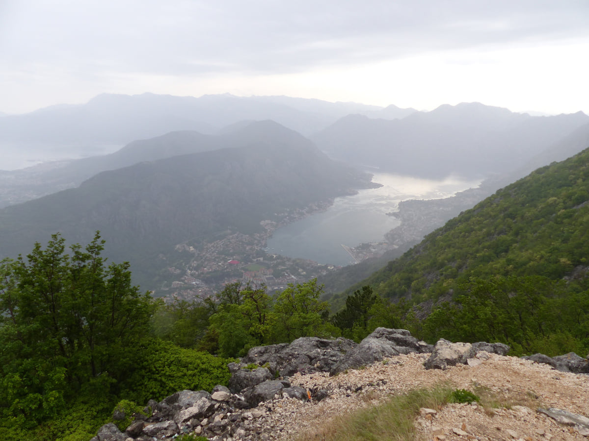
Between Tivat and Kotor
Vrmac, the mountain in the middle of the Bay of Kotor
Vrmac is the mountainous peninsula that separates Tivat from Kotor. It's 8 km long and 5 km wide, and its summits are Sveti Ilija at 785 m and Velji vrh at 712 m, according to the Tivat tourist board. There are walking and mountain-bike trails, drinking-water springs, remains of Ottoman, Venetian and Austro-Hungarian fortifications and views over the whole bay.
In 30 seconds
Full read: 2 min
- A mountainous peninsula between Tivat and Kotor, 8 by 5 km.
- Summits of Sveti Ilija (785 m) and Velji vrh (712 m).
- Walking and bike trails, springs and old forts from three empires.
- Views across the whole bay, the open sea and Lovćen.
With half a day spare in Tivat or Kotor, I'd spend it up here rather than on another beach. You climb through scented scrub and chestnut trees and see both halves of the bay at once, which you simply can't from the shore.

Before you go
What I would keep in mind
-
01 Most beautiful
Both bays from the top
From the summits you see Tivat and Kotor, the Bay of Kotor, the open sea and Lovćen, according to the Tivat tourist board.
-
02 My tip
Springs along the way
The Tivat tourist board says numerous drinking-water springs bubble up along the trails. I'd still carry water in summer.
-
03 Getting there
Gornja Lastva on the slopes
The stone village of Gornja Lastva, with its church of 1410, sits on Vrmac's sunny slope above Tivat.
Gornja Lastva -
04 To save money
A walk that costs nothing
There's no entry fee to walk on Vrmac. All you need is decent footwear, water and the legs for the climb.
What I would book
Seen from above, says the Tivat tourist board, Vrmac looks like a ship that’s just sailed into the bay. It’s the mountain between Tivat and Kotor, a long peninsula rising straight from the water that most visitors drive past without stopping. For me it’s among the bay’s most underrated outings, because nowhere else lets you see both halves of the Boka at the same time.
An 8 km ridge above the water
Vrmac is 8 km long and 5 km wide. Its two main summits are Sveti Ilija, 785 m, and Velji vrh, 712 m, according to the Tivat tourist board (OpenStreetMap puts Sveti Ilija at 766 m; I’ve stuck to the tourist board’s number). The ridge is mostly Mediterranean scrub, with the odd pasture among the rocks, wild chestnuts and black pines. The tourist board also calls it an important European mushroom area, which I didn’t see coming.
From the top you get Tivat on one side and Kotor on the other, the bay, the open sea and Lovćen behind. It’s the view that makes sense of the whole bay’s geography in one go.
Walking and biking
Walking is the main thing. Trails run round and over the mountain and work for mountain bikes too. The tourist board says springs of clear drinking water bubble up along the way and that the villages on the route feel like a step into another age. Even so, in July and August I’d set off early and carry plenty of water, because the scrub gives little shade and the sun here is a lot fiercer than a summer’s day on the Downs. The Foreign Office advice for Montenegro is worth heeding here too. Stick to marked trails, tell someone your route, keep your phone charged and ring 112 in an emergency.
To sleep close to everything, search places to stay in Tivat on Expedia and filter by area before price.
Three empires on one mountain
Its position always made Vrmac strategically important. There are remains of fortifications built and used by different powers over the centuries, defending the frontiers of the Ottoman Empire, the Republic of Venice or the Austro-Hungarian monarchy. The official sources I read don’t name each fort or give visiting hours, so I won’t sell them as an organised attraction; they’re ruins you come across on foot.
Churches and villages on the slopes
On the slope facing Tivat lies Gornja Lastva, the stone village with its church of 1410 and the best starting point for the mountain. On Gradac hill, also on Vrmac’s lower slopes, St Peter’s church keeps fragments of 13th-century frescoes that experts compare with the finest Byzantine painting of the time; it’s been protected since 1958. On the southern slopes stands the church of the Holy Physicians, Cosmas and Damian. On the Kotor side, at the foot of the mountain, are villages such as Prčanj.
To sleep close to everything, search places to stay in Tivat on Booking.com and filter by area before price.
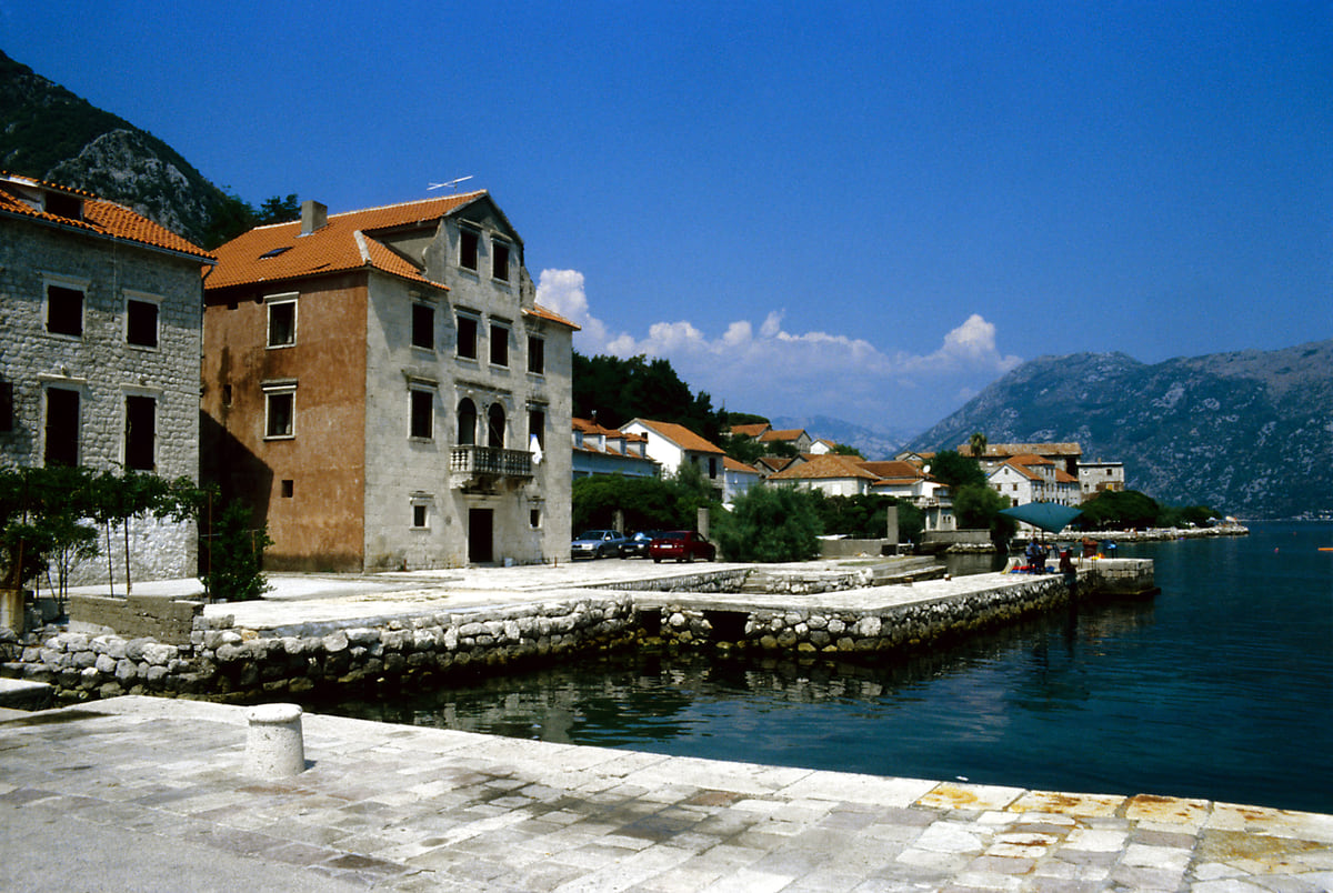
The quay at Prčanj with stone captains' houses beside the water of the Bay of Kotor and mountains beyond
Vrmac facts
| Item | Value | Source |
|---|---|---|
| Length | 8 km | Tivat Tourism Organisation |
| Width | 5 km | Tivat Tourism Organisation |
| Sveti Ilija | 785 m (766 m on OpenStreetMap) | Tivat Tourism Organisation |
| Velji vrh | 712 m | Tivat Tourism Organisation |
| St Peter's, Gradac | 13th-century frescoes, protected since 1958 | Tivat Tourism Organisation |
Checked on 10-10-2026. OpenStreetMap (© OpenStreetMap contributors, ODbL) gives a different height for Sveti Ilija; the official figure is used.
Test yourself
True or false?
0/3 Pick before you peek.
-
Vrmac separates Tivat from Kotor.
See the answer
True. The Tivat tourist board describes it as the mountain that both divides and links the two towns.
-
Vrmac's summit is over 1,000 m high.
See the answer
False. Its highest point, Sveti Ilija, is 785 m according to the Tivat tourist board.
-
Vrmac has remains of fortifications from several eras.
See the answer
True. The tourist board mentions Ottoman, Venetian and Austro-Hungarian remains.
- Sveti Ilija, the highest summit
- 785 m
- Length of the ridge
- 8 km
- Year St Peter's at Gradac was protected
- 1958
Map
Where Vrmac is
The Adriatic coast runs from Herceg Novi to Ulcinj; the centre holds Podgorica, Cetinje and Lake Skadar, and the north, Durmitor and the Tara Canyon. Every number opens its guide.
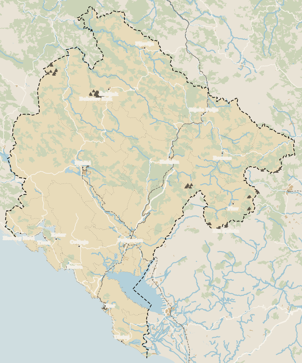 1Porto Montenegro 2Heroj submarine 3Tivat 4Vrmac 5Luštica peninsula 6Gornja Lastva 7Plavi horizonti beach 8Hotel Palma
 Map data © OpenStreetMap contributors (ODbL)
- 1Porto MontenegroTivat's marina
- 2Heroj submarinePorto Montenegro naval museum
- 3TivatTown on the coast
- 4VrmacBetween Tivat and Kotor
- 5Luštica peninsulaBetween Tivat and Herceg Novi
- 6Gornja LastvaHill village in Tivat municipality
- 7Plavi horizonti beachTivat beach on the Luštica peninsula
- 8Hotel PalmaFour-star hotel in Tivat
0 of 278 Montenegro guides
Your next stamp
- Tivat
- Most beautiful places
- Things to do
- Bay of Kotor
- Road trip
- Kotor viewpoints
- One-week itinerary
- Tivat Airport
- Aman Sveti Stefan
- Budva Old Town
- Haj-Nehaj
- Kotor
- Lučice Beach
- Montenegro's coast
- Peaks of the Balkans
- Porto Montenegro
- Sea Dance Festival
- Splendid Conference & Spa Resort
- Stari Bar
- Ulcinj Old Town
- Budva Riviera
- Heroj submarine
- Iberostar Bellevue
- Independence Day
- Old olive tree of Mirovica
- Velika plaža
- Ada Bojana
- Beaches in Budva
- Eurostars Queen of Montenegro
- Herceg Novi
- Kotor Old Town
- Mount Rumija
- Igalo
- Kotor city walls
- Mogren Beach
- Montenegro Beach Resort
- Svač
- Hiking
- Jaz Beach
- Kanli kula
- Luštica peninsula
- St Tryphon Cathedral
- Ulcinj salt pans
- Forte Mare
- Gornja Lastva
- Maritime Museum, Kotor
- Slovenska Beach
- Drobni Pijesak Beach
- Mamula
- Žanjic beach
- Kotor cruise port
- Orjen
- Plavi horizonti beach
- Sveti Nikola Island
- Blue Cave
- Restaurants in Budva
- Restaurants in Kotor
- Canyoning
- Hotels
- Perast
- Sutomore
- Sveti Stefan
- Čanj
- Luxury hotels
- Our Lady of the Rocks
- Pržno
- Activities
- All-inclusive hotels
- Bar Riviera
- Bečići
- Hotel Palma
- St George island
- Dobrota
- Hladna uvala
- Petrovac
- Crvena stijena
- Prčanj
- Prettiest villages
- Cycling
- Risan
- UNESCO sites
- Heritage Grand Perast
- Map
- Hyatt Regency Kotor Bay
- Where is it?
- Regions
- Cities
- Beaches in Bar
- Budva
- Central Montenegro
- Hotels in Budva
- Hotels in Kotor
- Iberostar Waves Herceg Novi
- Kitesurfing
- The name
- Beaches in Ulcinj
- Flag
- Hotels in Perast
- Palmon Bay Hotel & Spa
- Podgorica
- Cathedral of the Resurrection
- One&Only Portonovi
- Population
- Sandy beaches
- Azul Beach Resort Montenegro
- Naturist beaches
- Size
- Stara Varoš
- Doclea
- Language
- Mimosa Festival
- Medun
- Religion
- Zipline
- Currency
- Museums in Podgorica
- Dajbabe Monastery
- EU membership
- History
- Restaurants in Podgorica
- Hotels in Podgorica
- Public holidays
- Avala Resort & Villas
- Bar
- Beaches in Kotor
- Birdwatching
- Hotels in Ulcinj
- Kotor carnival
- Time zone
- Tivat beaches
- Tuzi
- Boka Night
- Dukley Hotel & Resort
- Facts
- Hotels in Tivat
- Zeta
- Caves
- Herceg Novi beaches
- National parks
- Šipčanik
- Hotels in Herceg Novi
- Monasteries
- Fortresses
- Fly fishing
- Museums
- Canyons and waterfalls
- Lakes
- Mountains
- Montenegro and Croatia
- Beaches
- Boat trips
- Cetinje
- Montenegro and Albania
- Nightlife
- Ulcinj
- Weather
- Best time to visit
- Cetinje Monastery
- Kayaking
- Montenegro and the Balkans
- How to get there
- In summer
- King Nikola's Palace
- Sailing
- Biljarda
- Flights
- In winter
- Airports
- Museums in Cetinje
- New Year's Eve
- Lovćen
- Paragliding
- Njegoš Mausoleum
- Podgorica Airport
- Dubrovnik to Kotor
- Kotor serpentine
- Belgrade to Montenegro
- Njeguši
- Ferry to Italy
- Njeguši prosciutto
- Border crossings
- In January
- Lipa Cave
- Where to stay
- In February
- Kamenari-Lepetane ferry
- Pavlova strana
- Getting around
- In March
- Rijeka Crnojevića
- In April
- Trains
- Buses
- In May
- Car hire
- In June
- Driving
- In July
- In August
- Taxis
- Distances
- In September
- In October
- Food
- In November
- Lake Skadar
- Scenic drives
- In December
- Kotor cable car
- Virpazar
- Where to eat
- Budva to Kotor
- Godinje
- Wine
- Podgorica to Kotor
- Vranjina
- Besac fortress
- Prices and budget
- On a budget
- Žabljak Crnojevića
- Danilovgrad
- Entry requirements
- Ostrog Monastery
- Tourist registration
- Customs
- Nikšić
- Crvena Stijena cave
- Safety
- Events
- Healthcare
- Northern Montenegro
- Mobile and roaming
- Žabljak
- Durmitor
- Plugs
- Black Lake
- With kids
- Bobotov Kuk
- Holidays
- Day trips
- Stećci tombstones
- Hotels in Žabljak
- Three-day itinerary
- Five-day itinerary
- Skiing in Montenegro
- Skiing in Žabljak
- Šavnik
- Ten-day itinerary
- Nevidio Canyon
- Tara Canyon
- Tara rafting
- Đurđevića Tara Bridge
- Plužine
- Lake Piva
- Piva Monastery
- Mojkovac
- Brskovo
- Pljevlja
- Husein Pasha Mosque
- Kolašin
- Hotels in Kolašin
- Skiing in Kolašin
- Biogradska Gora National Park
- Komovi
- Morača Monastery
- Morača Canyon
- Bijelo Polje
- Đalovića Cave
- Berane
- Andrijevica
- Petnjica
- Rožaje
- Plav
- Lake Plav
- Gusinje
- Vusanje
- Prokletije National Park
Frequently asked questions
Where is Mount Vrmac?
In the Bay of Kotor, between Tivat and Kotor. It's a mountainous peninsula jutting into the bay and dividing the two towns.
How high is Vrmac?
Its highest summit is Sveti Ilija at 785 m, according to the Tivat tourist board, followed by Velji vrh at 712 m.
Can you hike on Vrmac?
Yes. Trails run round and over the mountain and suit mountain bikes too, with drinking-water springs and villages along the way.
Are there forts on Vrmac?
There are remains of fortifications built and used over the centuries by the Ottomans, Venice and Austria-Hungary. The official sources don't list visiting hours for any of them.
Can you see Kotor from Vrmac?
Yes. From the top you look down on Kotor and Tivat, across the whole bay to the open sea, and over to Lovćen.
By
Tourism graduate with a master’s in Tourism Management and Planning from the University of Málaga, who has travelled across Europe. He writes every guide from official sources and his own judgement.
Published on . Facts checked on .
Sources
Some links in this guide are affiliate links: if you book through them, the site earns a commission at no extra cost to you. Affiliate disclosure
Photos: Wolfgang Sauber (CC BY-SA 4.0); Falk2 (CC BY-SA 4.0), via Wikimedia Commons.