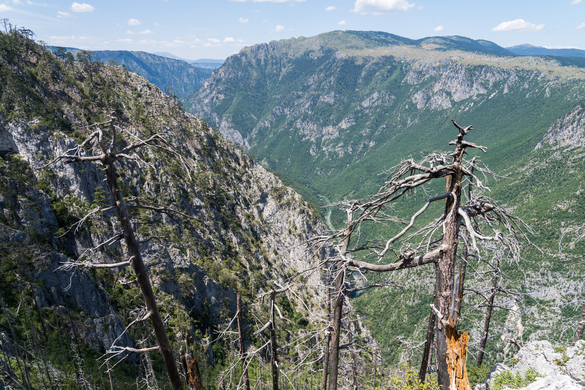
Gorges, canyoning routes and falls
Canyons and waterfalls of Montenegro, from the Tara to Grlja
Montenegro has some of Europe's deepest canyons. The Tara reaches 1,333 m deep according to the National Tourism Organisation, and Nevidio, on the Komarnica, has drops of up to 10 m. Waterfalls appear mainly in canyoning routes and in Prokletije, near Vusanje.
In 30 seconds
Full read: 2 min
- The Tara Canyon reaches 1,333 m deep.
- Nevidio has drops of up to 10 m and is guided only.
- Near Kotor is Škurda and near Stari Bar, Vruća rijeka.
- Waterfalls are mostly found in canyoning routes and in Prokletije.
To see a canyon without any gear, I'd go to the Đurđevića Tara Bridge and a Tara viewpoint. To get inside one, I'd choose Tara rafting over Nevidio, which is technical canyoning and something I'd only do with a guide.

Before you go
What I would keep in mind
-
01 Most beautiful
The Tara, 78 km of canyon
The National Tourism Organisation gives 78 km of gorge between the mouth of the Bistrica and Šćepan Polje, with a maximum depth of 1,333 m between Obzor and Štuoc.
Tara Canyon -
02 Worth the splurge
Rafting the Tara
Around €70 for one day and from €90 for two, April to October, on the 18 km stretch from Brštanovica to Šćepan Polje, according to the National Tourism Organisation.
rafting on the Tara -
03 My tip
Nevidio, guided only
It's 3,500 m of the Komarnica, with drops of up to 10 m and about four hours of descent. It was first traversed in 1965. This is not a stroll.
Nevidio Canyon -
04 Most beautiful
Grlja and Oko Skakavice
In Prokletije, the Grlja canyon is 500 m long and 50 m deep, starting where the Skakavica joins the Vusanje stream, according to the National Tourism Organisation.
Vusanje
What I would book
Look for waterfalls in Montenegro and you’ll mostly find canyons, which is no bad thing. The country has gorges more than a kilometre deep, technical canyoning routes that end beside medieval walls and falls tucked away in the mountains. Here they are from easiest to most demanding, using figures from the National Tourism Organisation and the National Parks.
The Tara, the canyon to see
It’s the country’s great canyon. The National Tourism Organisation gives 78 km of gorge between the mouth of the Bistrica and Šćepan Polje, with a maximum depth of 1,333 m between Obzor and Štuoc, and UNESCO calls it Europe’s deepest gorge. You can see it without getting wet from the Đurđevića Tara Bridge, a 365 m concrete span on five arches finished in 1940, where a zip line launches at around 150 m above the river. Or you can travel through it by raft, from April to October, along the 18 km stretch between Brštanovica and Šćepan Polje. It’s all in the Tara Canyon and Tara rafting.
Piva, Komarnica and Nevidio
West of Durmitor, the Piva and the Komarnica carve canyons around Lake Piva, which you can tour by boat according to the National Tourism Organisation. Inside the Komarnica is Nevidio, 3,500 m of gorge with jumps as high as 10 m, taking roughly four hours to descend, first traversed in full only in 1965 and also known as Neviđbog. This is proper canyoning, with kit and a guide. I cover it in Nevidio Canyon.
If you are staying the night, see the best hotel deals in Žabljak for your dates: the well-placed rooms go fast.
The Morača, the one you see from the car
The Morača is the canyon most people see without meaning to, because the road between Podgorica and the north runs through it. gov.uk flags this two-lane road as risky when the weather turns or the traffic builds, so I’d enjoy it as a passenger, in daylight, and leave the overtaking to the locals. Morača Monastery stands in the same valley, in the municipality of Kolašin. Driving it is covered in the Morača Canyon.
Prokletije, canyons with waterfalls
The falls closest to what people are searching for are in Prokletije. The National Parks describe trails through the Grbaja and Ropojana valleys taking in the Ropojana lake, the Oko Skakavice spring, the Grlja canyon and waterfalls. Grlja is 500 m long, 50 m deep and between 2 and 7 m wide, was discovered in 1982 and begins where the Skakavica meets the Vusanje stream. The village you set off from is covered in Vusanje.
If you are staying the night, see the best hotel deals in Žabljak for your dates: the well-placed rooms go fast.
Canyoning routes by the sea
Two of them end, quite literally, in an old town. Škurda is 1.2 km long, begins about 200 m below the Krstac pass and spits you out at the foot of Kotor’s walls six or seven hours later. Vruća rijeka covers about 6 km in six to eight hours and runs from Veliki Mikulići down to the walls of Stari Bar. Both are technical, and to me they only make sense with a specialist operator. Near Podgorica, the tourism board also lists the Cijevna canyon, which reaches as far as Tuzi.
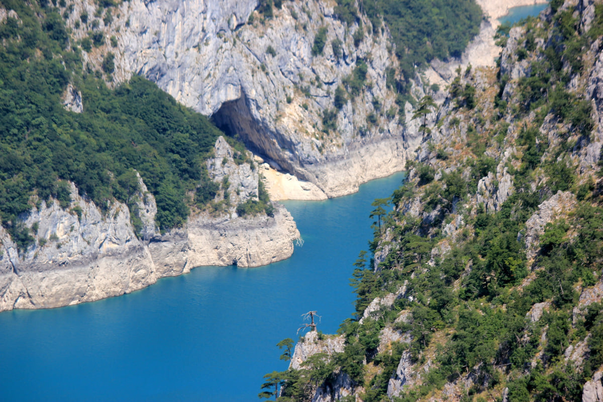
The Piva canyon with the blue water of the reservoir between pale rock walls and forest on the slopes
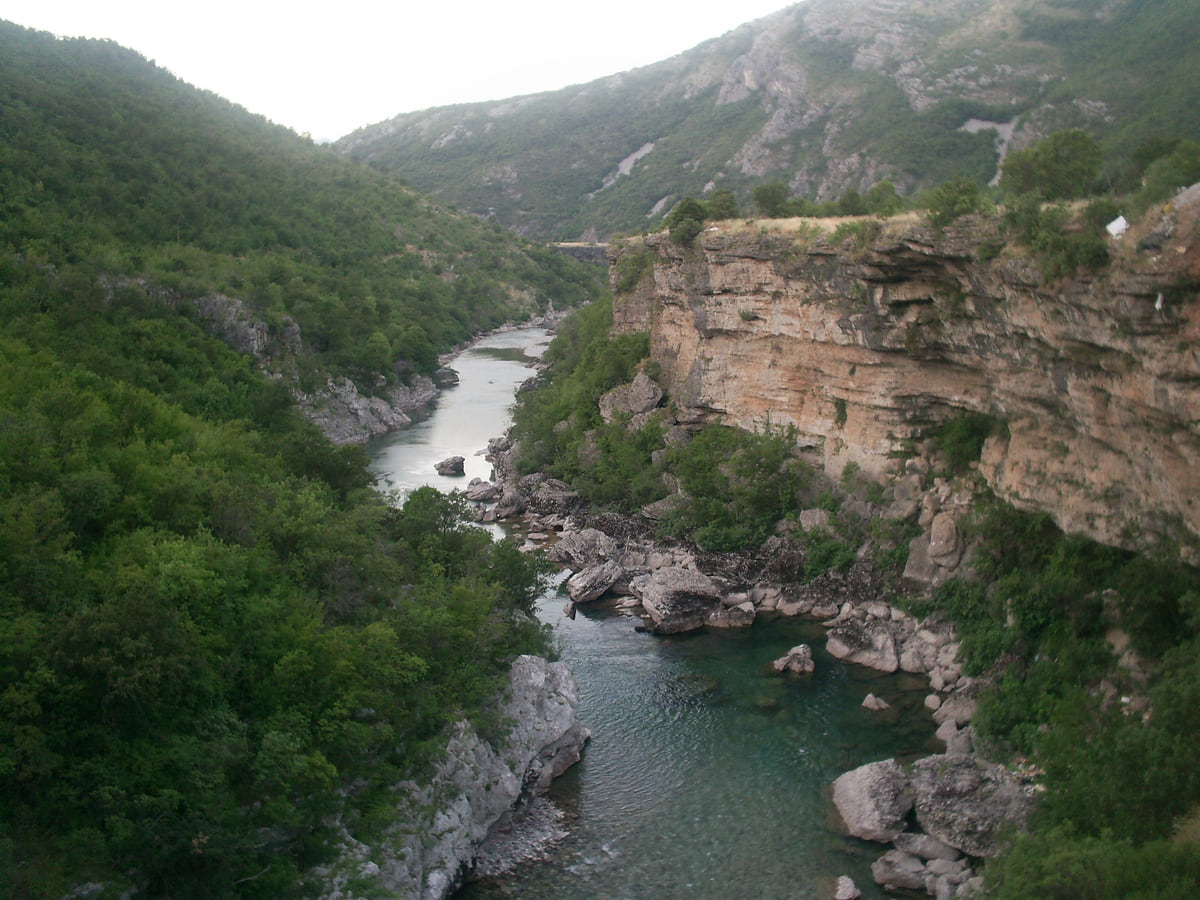
The River Morača at the bottom of its canyon, between rock walls and wooded slopes, with clear green water
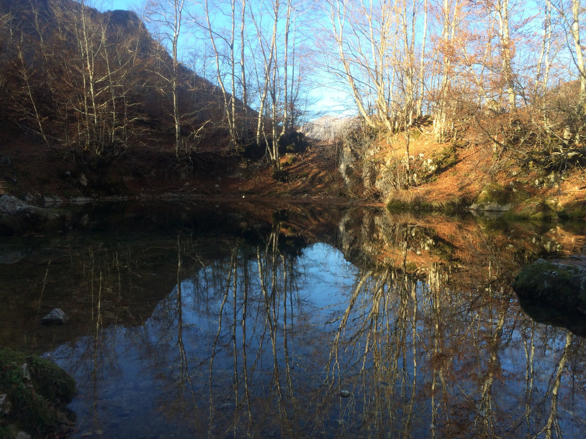
The Oko Skakavice spring near Vusanje in Prokletije, its still water reflecting bare trees in autumn
Canyons with an official write-up
| Canyon | Where | Figures | Source |
|---|---|---|---|
| Tara | North, between Durmitor and the border | 78 km, up to 1,333 m deep | National Tourism Organisation |
| Piva and Komarnica | Plužine | Canyons around Lake Piva | National Tourism Organisation |
| Nevidio | Šavnik | 3,500 m, drops up to 10 m, about 4 h | National Tourism Organisation |
| Morača | Between Podgorica and Kolašin | Road risky in bad weather | gov.uk |
| Grlja | Vusanje, Gusinje | 500 m long, 50 m deep, 2 to 7 m wide | National Tourism Organisation |
| Škurda | Kotor | 1.2 km, 6 to 7 h of canyoning | National Tourism Organisation |
| Vruća rijeka | Bar | About 6 km, 6 to 8 h, ending at Stari Bar | National Tourism Organisation |
| Cijevna | Podgorica and Tuzi | River and canyon | Podgorica Tourism Organisation |
Checked on 10-10-2026.
Test yourself
True or false?
0/3 Pick before you peek.
-
The Tara Canyon is more than 1,000 m deep.
See the answer
True. The National Tourism Organisation gives it a maximum depth of 1,333 m.
-
Nevidio was first traversed in the 19th century.
See the answer
False. It was in 1965, according to the National Tourism Organisation.
-
Škurda Canyon finishes beside Kotor's walls.
See the answer
True. It starts below the Krstac pass and ends next to the walls after six or seven hours.
- Maximum depth of the Tara
- 1,333 m
- Length of the Tara Canyon
- 78 km
- Length of Nevidio
- 3,500 m
- First descent of Nevidio
- 1965
0 of 278 Montenegro guides
Your next stamp
- Canyoning
- Morača Canyon
- Tara Canyon
- Northern Montenegro
- Activities
- Kolašin
- Hiking
- Zipline
- Aman Sveti Stefan
- Budva Old Town
- Haj-Nehaj
- Kotor
- Lučice Beach
- Montenegro's coast
- Peaks of the Balkans
- Porto Montenegro
- Sea Dance Festival
- Splendid Conference & Spa Resort
- Stari Bar
- Ulcinj Old Town
- Bay of Kotor
- Budva Riviera
- Heroj submarine
- Iberostar Bellevue
- Independence Day
- Old olive tree of Mirovica
- Tivat
- Velika plaža
- Ada Bojana
- Beaches in Budva
- Eurostars Queen of Montenegro
- Herceg Novi
- Kotor Old Town
- Mount Rumija
- Igalo
- Kotor city walls
- Mogren Beach
- Montenegro Beach Resort
- Svač
- Vrmac
- Jaz Beach
- Kanli kula
- Luštica peninsula
- St Tryphon Cathedral
- Ulcinj salt pans
- Forte Mare
- Gornja Lastva
- Maritime Museum, Kotor
- Slovenska Beach
- Drobni Pijesak Beach
- Kotor viewpoints
- Mamula
- Žanjic beach
- Kotor cruise port
- Orjen
- Plavi horizonti beach
- Sveti Nikola Island
- Blue Cave
- Restaurants in Budva
- Restaurants in Kotor
- Hotels
- Perast
- Sutomore
- Sveti Stefan
- Čanj
- Luxury hotels
- Our Lady of the Rocks
- Pržno
- Things to do
- All-inclusive hotels
- Bar Riviera
- Bečići
- Hotel Palma
- St George island
- Dobrota
- Hladna uvala
- Most beautiful places
- Petrovac
- Crvena stijena
- Prčanj
- Prettiest villages
- Cycling
- Risan
- UNESCO sites
- Heritage Grand Perast
- Map
- Hyatt Regency Kotor Bay
- Where is it?
- Regions
- Cities
- Beaches in Bar
- Budva
- Central Montenegro
- Hotels in Budva
- Hotels in Kotor
- Iberostar Waves Herceg Novi
- Kitesurfing
- The name
- Beaches in Ulcinj
- Flag
- Hotels in Perast
- Palmon Bay Hotel & Spa
- Podgorica
- Cathedral of the Resurrection
- One&Only Portonovi
- Population
- Sandy beaches
- Azul Beach Resort Montenegro
- Naturist beaches
- Size
- Stara Varoš
- Doclea
- Language
- Mimosa Festival
- Medun
- Religion
- Currency
- Museums in Podgorica
- Dajbabe Monastery
- EU membership
- History
- Restaurants in Podgorica
- Hotels in Podgorica
- Public holidays
- Avala Resort & Villas
- Bar
- Beaches in Kotor
- Birdwatching
- Hotels in Ulcinj
- Kotor carnival
- Time zone
- Tivat beaches
- Tuzi
- Boka Night
- Dukley Hotel & Resort
- Facts
- Hotels in Tivat
- Zeta
- Caves
- Herceg Novi beaches
- National parks
- Šipčanik
- Hotels in Herceg Novi
- Monasteries
- Fortresses
- Fly fishing
- Museums
- Lakes
- Mountains
- Montenegro and Croatia
- Beaches
- Boat trips
- Cetinje
- Montenegro and Albania
- Nightlife
- Ulcinj
- Weather
- Best time to visit
- Cetinje Monastery
- Kayaking
- Montenegro and the Balkans
- How to get there
- In summer
- King Nikola's Palace
- Sailing
- Biljarda
- Flights
- In winter
- Airports
- Museums in Cetinje
- New Year's Eve
- Lovćen
- Paragliding
- Tivat Airport
- Njegoš Mausoleum
- Podgorica Airport
- Dubrovnik to Kotor
- Kotor serpentine
- Belgrade to Montenegro
- Njeguši
- Ferry to Italy
- Njeguši prosciutto
- Border crossings
- In January
- Lipa Cave
- Where to stay
- In February
- Kamenari-Lepetane ferry
- Pavlova strana
- Getting around
- In March
- Rijeka Crnojevića
- In April
- Trains
- Buses
- In May
- Car hire
- In June
- Driving
- In July
- In August
- Taxis
- Distances
- In September
- In October
- Road trip
- Food
- In November
- Lake Skadar
- Scenic drives
- In December
- Kotor cable car
- Virpazar
- Where to eat
- Budva to Kotor
- Godinje
- Wine
- Podgorica to Kotor
- Vranjina
- Besac fortress
- Prices and budget
- On a budget
- Žabljak Crnojevića
- Danilovgrad
- Entry requirements
- Ostrog Monastery
- Tourist registration
- Customs
- Nikšić
- Crvena Stijena cave
- Safety
- Events
- Healthcare
- Mobile and roaming
- Žabljak
- Durmitor
- Plugs
- Black Lake
- With kids
- Bobotov Kuk
- Holidays
- Day trips
- Stećci tombstones
- Hotels in Žabljak
- Three-day itinerary
- Five-day itinerary
- Skiing in Montenegro
- One-week itinerary
- Skiing in Žabljak
- Šavnik
- Ten-day itinerary
- Nevidio Canyon
- Tara rafting
- Đurđevića Tara Bridge
- Plužine
- Lake Piva
- Piva Monastery
- Mojkovac
- Brskovo
- Pljevlja
- Husein Pasha Mosque
- Hotels in Kolašin
- Skiing in Kolašin
- Biogradska Gora National Park
- Komovi
- Morača Monastery
- Bijelo Polje
- Đalovića Cave
- Berane
- Andrijevica
- Petnjica
- Rožaje
- Plav
- Lake Plav
- Gusinje
- Vusanje
- Prokletije National Park
Frequently asked questions
Are there waterfalls in Montenegro?
Yes, though official sources talk more about canyons than falls. The National Parks mention waterfalls on the Prokletije trails around Grbaja and Ropojana, and canyoning routes such as Nevidio have drops of up to 10 m.
How deep is the Tara Canyon?
Up to 1,333 m between Obzor and Štuoc, according to the National Tourism Organisation. UNESCO describes it as Europe's deepest gorge.
Can you see the Tara Canyon without rafting?
Yes. The Đurđevića Tara Bridge, five arches and 365 m long, completed in 1940, spans the canyon, and a zip line runs from there at a height of around 150 m.
What is Nevidio Canyon?
A canyoning route on the Komarnica river in Šavnik, 3,500 m long with drops of up to 10 m and about four hours of descent. The National Tourism Organisation says it was first traversed in 1965.
Is there canyoning near Kotor?
Yes, Škurda, 1.2 km long, which starts below the Krstac pass and finishes beside Kotor's walls after six or seven hours of technical canyoning, according to the National Tourism Organisation.
By
Tourism graduate with a master’s in Tourism Management and Planning from the University of Málaga, who has travelled across Europe. He writes every guide from official sources and his own judgement.
Published on . Facts checked on .
Sources
Some links in this guide are affiliate links: if you book through them, the site earns a commission at no extra cost to you. Affiliate disclosure
Photos: Alexkom000 (CC BY 4.0); Julian Nyča (CC BY-SA 4.0); Kris12 (CC BY-SA 3.0); KpokeJlJla (CC BY-SA 4.0), via Wikimedia Commons.