Walking routes
Hiking in Malta: the walks I'd do, and when to do them
For hiking in Malta, the best ground is on Gozo, which has nine walking trails planned by its Ministry, and on Comino, which you can walk end to end in about three hours. On the main island, the Dingli Cliffs and Buskett make the most rewarding outing. I'd walk from October to May and give July and August a miss.
In 30 seconds
Full read: 3 min
- Gozo is the best island for walking, with nine trails planned by its Ministry.
- Comino takes about three hours on foot and has no shops or services.
- On Malta, the Dingli Cliffs and Buskett are the easiest walk without a car.
- Avoid midday in July and August, and bear in mind the spring and autumn shooting seasons.
If I had a single day to walk in Malta, I'd take the first ferry to Gozo and do one of its coastal routes. The main island has pleasant strolls, but Gozo is more rural and its trails are actually designed to be walked.

Before you go
What I would keep in mind
-
01 Most beautiful
Comino, end to end on foot
The Ministry for Gozo reckons on about three hours to walk round Comino. There are no roads, shops or services beyond seasonal kiosks, so take water, food and sun cream.
Comino island -
02 My tip
Mind the shooting season
GOV.UK warns that bird hunting with firearms takes place in spring and autumn, from two hours before sunrise to two hours after sunset, in areas that can overlap with public paths.
-
03 Getting there
Buses 52 and 56 to Dingli and Buskett
Both routes run from Valletta to Dingli, with Buskett right next door. It's the simplest way to combine the woodland and the cliffs in one walk without a car.
Buskett Gardens -
04 To save money
Walking is free, the ferry nearly so
The trails cost nothing and the Gozo Channel ferry is €4.65 return, paid on the way back. It's the cheapest day in the countryside you can have on the islands.
Malta to Gozo ferry
My ranking, scored
The walks in Malta I'd do, in order
My own score out of 10. I weigh the scenery, whether the route is backed by an official source, and how easy it is to reach the start by public transport.
0 of 7 seen
-
Round Comino
About three hours on foot across a car-free island, with St Mary's Tower and Santa Marija Bay. Boats run from Mġarr on Gozo and from Ċirkewwa.
9.2 out of 10
-
Xlendi Walk (Gozo)
The path out of Xlendi with views of the Ta' Ċenċ and Sanap cliffs, Gozo's highest according to the Ministry.
8.9 out of 10
-
Dingli Cliffs and Buskett
Malta Public Transport singles out Dingli for its views and hiking trails, and neighbouring Buskett for walks and picnics.
8.6 out of 10
-
Ramla Walk (Gozo)
From Marsalforn to Ramla Bay by way of Xagħra. Ending on Gozo's best-known red-sand beach is the finest reward I can think of.
8.4 out of 10
-
Ħondoq ir-Rummien Walk (Gozo)
A circuit from Mġarr through Qala, Nadur and Għajnsielem, with Ħondoq bay halfway round and Comino across the water.
8.1 out of 10
-
Ta' Ġurdan route (Gozo)
About 10 km through western Gozo, around San Dimitri, the island's westernmost chapel. The longest route with a published distance.
7.8 out of 10
-
Għajn Tuffieħa coast
Malta Public Transport mentions cliffs for walking and watchtowers by the bay. Bus 44 from Valletta.
7.4 out of 10
Malta isn’t a place most people pack walking boots for, and I understand why. It’s a small, crowded country whose highest point is 253 m. That’s exactly where people get it wrong, though, because the islands have miles of cliff coastline, valleys running down to the sea and an entire island with no cars. This is how I’d approach it, sticking to routes that an official source backs up.
Gozo, the island made for walking
If you’re walking for just one day, make it Gozo. The Ministry for Gozo describes the island as more rural and more tranquil than Malta, and publishes nine planned walking trails. They include Daħlet Qorrot, a loop from Nadur, the Ħondoq ir-Rummien Walk, starting in Mġarr and taking in Qala, Nadur and Għajnsielem along the way, the Xagħra Heritage Trail and the Ramla Walk, which runs from Marsalforn to Ramla Bay via Xagħra.
On paper my favourite is the Xlendi Walk, because it starts from a village served by the 330 bus from Victoria and puts the Ta’ Ċenċ cliffs, Gozo’s highest according to the Ministry, right in front of you. The background is in the Ta’ Ċenċ cliffs. Further west, the Ta’ Ġurdan route covers about 10 km around San Dimitri, the island’s westernmost chapel. Getting to and around the island is covered in Gozo.
Comino in three hours, and what to pack
Comino is the clearest case of all. The Ministry for Gozo says you can walk it in about three hours and that it has no roads, shops or services beyond seasonal kiosks. Boats run from Mġarr on Gozo in about 15 minutes and from Ċirkewwa in about 35. I’d go outside July and August, set off early, carry more water than seems sensible and keep clear of the Blue Lagoon at its busiest hours. The full picture is in Comino island.
Where to walk on the main island
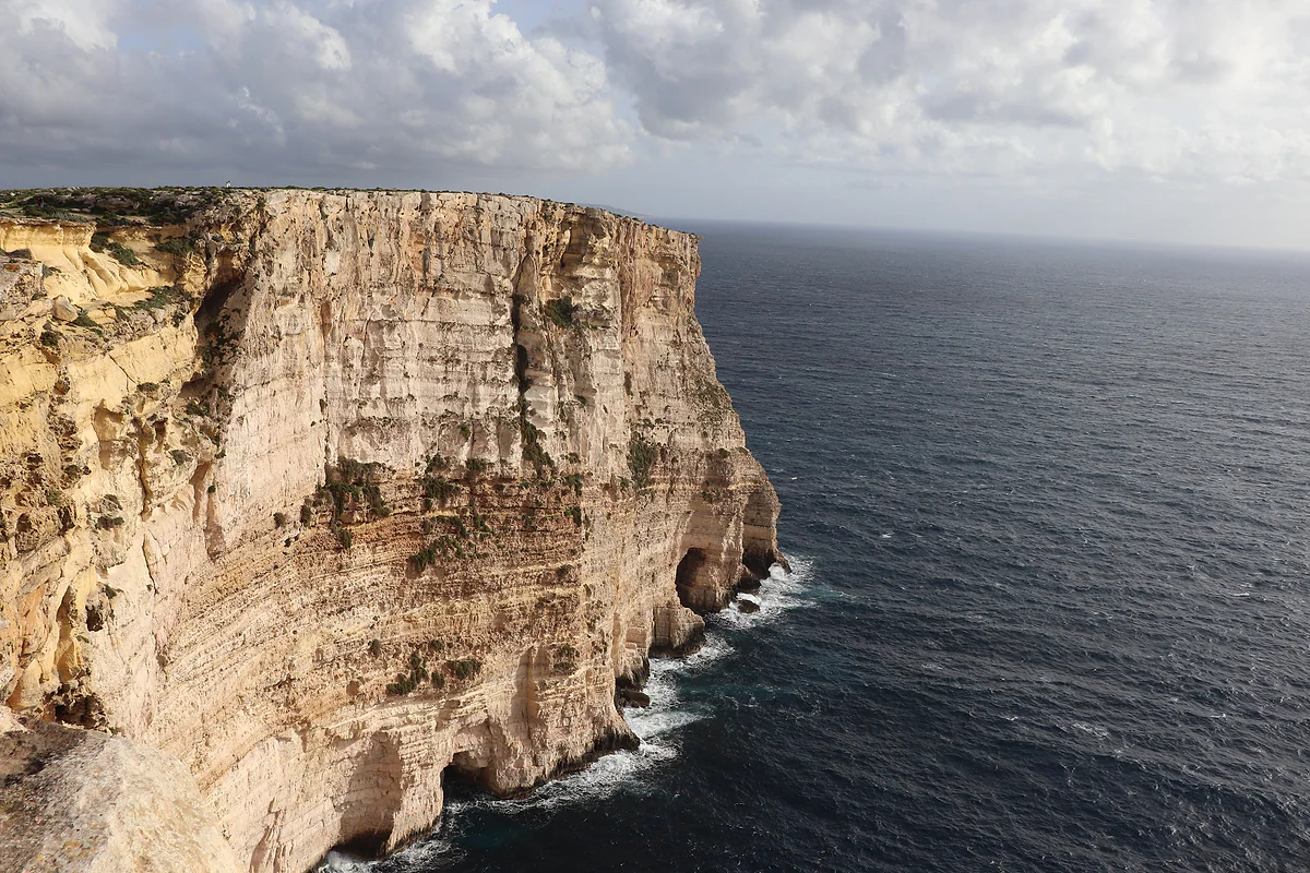
On Malta itself, the walk I’d choose is along the Dingli Cliffs, which Malta Public Transport describes as famous for their views and hiking trails. They rise to 230 m above the sea, and right next door is Buskett, which BirdLife Malta calls the country’s only semi-natural woodland and which is open at all hours. Buses 52 and 56 from Valletta drop you at Dingli.
Up north, Malta Public Transport mentions the Għajn Tuffieħa coast for its cliffs to walk along and its watchtowers. And across the middle of the island run the Victoria Lines, the fortified line that follows the Great Fault. Here I’d rather be completely honest with you. Not one official source I’ve found publishes a waymarked path along them or its length, so I won’t give you distances.
When to walk, and when not to
Heat is the first thing to plan around. The Meteorological Office gives a July mean of 26.9 °C and average August highs of 32 °C, and in June 2021 it hit 41.5 °C. There’s no shade on the coast. That’s why I’d walk from October to May, and in summer only first thing in the morning.
The second is hunting. GOV.UK warns that bird shooting with firearms takes place in spring and autumn, from two hours before sunrise to two hours after sunset, in areas that can overlap with paths, and that there have been incidents with members of the public. In those seasons, I’d stay on the marked routes and leave open country for another time.
Cliffs, sea and common sense
The Ministry for Gozo advises against going near the shore at Dwejra when the sea is rough, and at Wied il-Għasri, a gorge with steps cut into the rock, it suggests watching storms from a safe distance. I’d apply the same rule to every cliff on the islands, Dingli included. I’d wear proper shoes, as on any rocky coast, and keep the emergency number, 112, to hand. Everything else on staying safe is in is Malta safe.

Orange trees and woodland in Buskett Gardens, the greenest woodland in Malta, next to Verdala Palace.
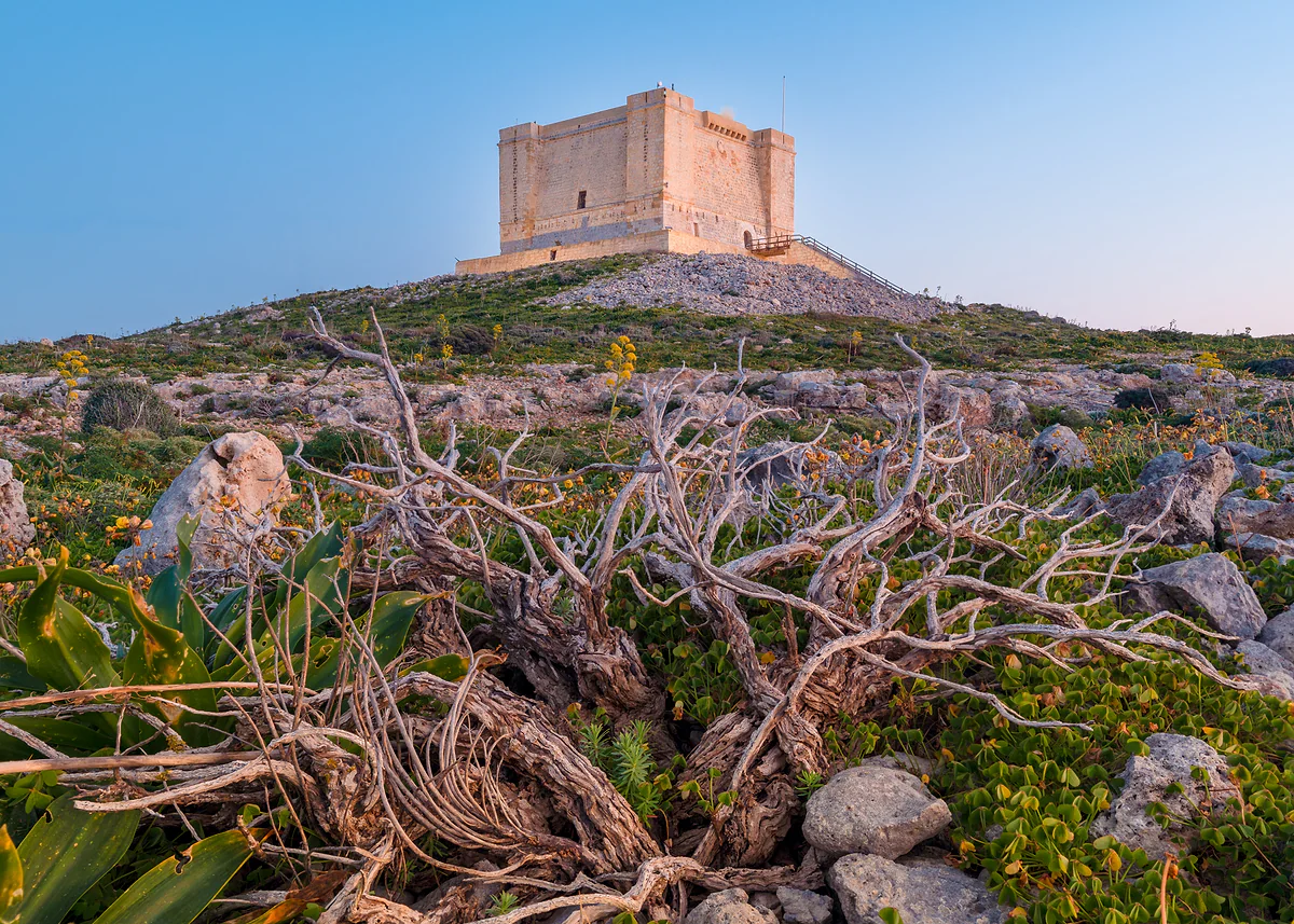
St Mary's Tower on Comino, the square stone fort built by the Knights of St John, standing on the island's scrub-covered plateau.
Walking routes on Malta, Gozo and Comino with an official source
| Route | Island | Start | What you'll see |
|---|---|---|---|
| Round Comino | Comino | Wherever the boat drops you, from Mġarr or Ċirkewwa | 1618 tower, Santa Marija Bay, caves |
| Xlendi Walk | Gozo | Xlendi (bus 330 from Victoria) | Ta' Ċenċ and Sanap cliffs |
| Ramla Walk | Gozo | Marsalforn | Xagħra and Ramla Bay |
| Ħondoq ir-Rummien Walk | Gozo | Mġarr | Qala, Nadur, Għajnsielem and Ħondoq bay |
| Daħlet Qorrot | Gozo | Nadur | Boathouses cut into caves |
| Xagħra Heritage Trail | Gozo | Xagħra | The heritage of Xagħra, home of Ġgantija |
| Ta' Ġurdan, about 10 km | Gozo | Għarb | Western Gozo and San Dimitri chapel |
| Dingli and Buskett | Malta | Dingli (buses 52 and 56) | Cliffs up to 230 m and Buskett woodland |
Routes from visitgozo.com (Ministry for Gozo) and walks described by Malta Public Transport. Distances and climbs are given only where the source publishes them.
Test yourself
True or false?
0/3 Pick before you peek.
-
Gozo has walking routes planned by its own Ministry.
See the answer
True. visitgozo.com, run by the Ministry for Gozo, says the island offers nine planned walking trails, including the Ħondoq ir-Rummien and Ramla routes.
-
Comino has shops and water points along the way.
See the answer
False. The Ministry for Gozo says Comino has no roads, shops or services apart from seasonal kiosks.
-
Bird shooting in Malta takes place in spring and autumn.
See the answer
True. GOV.UK says so, with hunting permitted from two hours before sunrise until two hours after sunset, in areas that overlap with public spaces.
- Planned walking trails on Gozo
- 9
- To walk round Comino
- 3 hrs
- Ta' Ġurdan route, Gozo
- 10 km
- Average August high
- 32 °C
0 of 279 Malta guides
Your next stamp
- Malta in five days
- Malta in a week
- The Maltese islands
- Comino
- Most beautiful places
- Gozo
- Things to do in Malta
- Comino ferry
- Prettiest villages
- UNESCO World Heritage Sites
- Where is Malta
- Towns and villages
- Island of Malta
- Blue Lagoon
- Fort Rinella
- Fort St Angelo
- Gardjola Gardens
- Ħal Saflieni Hypogeum
- Is Malta a country?
- Popeye Village
- Tarxien Temples
- Things to do in Gozo
- Valletta
- Esplora
- Golden Bay
- Gozo day trip
- Inquisitor's Palace
- Population
- St John's Co-Cathedral
- St Mary's Tower
- Grandmaster's Palace
- How big is Malta
- Maritime Museum
- Mellieħa Bay
- Fort St Elmo
- Language
- Malta at War Museum
- Paradise Bay
- Barrakka Gardens
- Red Tower
- Religion
- Malta government
- Saluting Battery
- MUŻA
- National Museum of Archaeology
- Underground Valletta
- Lascaris War Rooms
- Casa Rocca Piccola
- Malta in one day
- Three Cities
- Victoria
- Birgu
- Manoel Theatre
- Weekend in Malta
- Xagħra
- City Gate and Parliament
- Malta in three days
- Nadur
- Senglea
- Cospicua
- Malta in four days
- Qala
- Valletta Waterfront
- Għajnsielem
- Kalkara
- Paola
- Xewkija
- Sannat
- Tarxien
- Munxar
- Żabbar
- Fgura
- Fontana
- Kerċem
- Luqa
- Floriana
- Marsa
- Mellieħa
- The Citadel, Gozo
- Żebbuġ (Gozo)
- Ġgantija Temples
- Marsalforn
- Santa Luċija
- Ramla Bay
- San Lawrenz
- Xgħajra
- Xwejni salt pans
- Calypso's Cave
- Għarb
- Żejtun
- Għasri
- Gudja
- San Blas Bay
- Għaxaq
- Ħondoq Bay
- Marsaxlokk
- Kirkop
- Marsaxlokk Fish Market
- Mqabba
- St Peter's Pool
- Marsaskala
- Qrendi
- Żurrieq
- Beaches
- EU, Schengen and the euro
- Ħaġar Qim and Mnajdra
- Mdina
- Mġarr (Gozo)
- Blue Grotto
- Diving
- Entry requirements
- Mdina Cathedral
- Xewkija Rotunda
- Birżebbuġa
- Money and payments
- Palazzo Falson
- Safi
- Shipwrecks
- Ta' Ċenċ Cliffs
- Għar Dalam
- Mdina Dungeons
- Mġarr ix-Xini
- Prices and budget
- Snorkelling
- Boat trips
- Malta on a budget
- Playmobil FunPark
- Rabat (Malta)
- Xlendi
- Dwejra
- Gozo beaches
- History
- Siġġiewi
- St Paul's Catacombs
- Tipping
- Azure Window
- Domvs Romana
- Għar Lapsi
- Great Siege of 1565
- Plugs
- Limestone Heritage Park
- Second World War
- St Paul's Grotto
- Ta' Pinu Basilica
- Time zone
- Buskett Gardens
- Knights of Malta
- Mobile and roaming
- Wied il-Għasri
- Dingli
- Maltese cross
- Dingli Cliffs
- Flag
- Żebbuġ
- Coat of arms
- Mtarfa
- Balzan
- National anthem
- Lija
- Malta facts
- Game of Thrones
- Iklin
- Attard
- Film locations
- Forts and fortifications
- San Anton Gardens
- Ta' Qali Crafts Village
- Victoria Lines
- Megalithic temples
- Catacombs
- Museums
- Where to eat
- Where to stay
- Churches
- Hotels in Valletta
- Restaurants in Valletta
- Hotels in Sliema
- Maltese food
- Restaurants in Marsaxlokk
- Viewpoints
- Hotels in St Julian's
- Pastizzi
- Hotels in Buġibba and Qawra
- Maltese rabbit stew
- Safety
- Hotels in Mellieħa
- Kinnie and Cisk
- Scams
- Gozo hotels
- Nightlife
- Tap water
- Boat parties
- Holiday packages
- Tourist tax
- All inclusive
- Gay Malta
- Sightseeing passes
- Apartments
- Malta with kids
- Public holidays
- How to get there
- Luxury
- Malta for couples
- Taxis and ride-hailing
- Weather
- Best time to visit
- Cycling
- English schools
- Flights
- Flights from Madrid
- Sea temperature
- Shopping and souvenirs
- Airport
- Free walking tours
- In winter
- Airport transfers
- Day trips and tours
- In summer
- Ferry from Sicily
- In January
- Cruise stop
- In February
- In March
- In April
- In May
- Getting around
- In June
- Buses
- July
- August
- Hop on hop off
- Gozo ferry
- September
- Gozo fast ferry
- October
- November
- Valletta ferries
- Car hire
- December
- Driving
- Events
- St Paul's Bay
- Village feasts
- Buġibba
- Christmas
- Easter
- Qawra
- Carnival
- Xemxija
- Fireworks festival
- Malta National Aquarium
- Isle of MTV
- St Paul's Islands
- Mosta
- Mosta Rotunda
- Naxxar
- Palazzo Parisio
- Għargħur
- Mġarr (Malta)
- Sliema
- Ta' Ħaġrat and Skorba Temples
- Għajn Tuffieħa Bay
- Tigné Point
- Ġnejna Bay
- St Julian's
- Paceville
- St George's Bay
- Gżira
- Msida
- Ta' Xbiex
- Pietà
- Pembroke
- Swieqi
- San Ġwann
- Birkirkara
- Ħamrun
- Santa Venera
- Qormi
Frequently asked questions
Is Malta good for hiking?
Yes, especially Gozo, which has nine walking trails planned by its Ministry, and Comino. On the main island, the Dingli Cliffs, Buskett and the Għajn Tuffieħa coast are the walks with the most official backing.
When is the best time for hiking in Malta?
I'd walk between October and May. The July mean is around 26.9 °C and average highs reach 32 °C in August, and there's no shade on the coastal routes.
How long does it take to walk around Comino?
About three hours, according to the Ministry for Gozo. There are no shops or services beyond seasonal kiosks, so take water and food.
Are the Victoria Lines a waymarked walking trail?
I haven't found any official source publishing a waymarked path along them or its length. UNESCO lists them on its Tentative List as a fortification, not as a route.
Is it safe to walk in the countryside during the hunting season?
GOV.UK warns that bird hunting with firearms happens in spring and autumn, from two hours before sunrise to two hours after sunset, in areas that can overlap with paths. I'd stick to marked routes and avoid open country at dawn.
Can you walk right up to the cliff edges?
The Ministry for Gozo advises against going near the shore at Dwejra in rough seas, and at Wied il-Għasri suggests watching storms from a safe distance. I'd apply that rule to every cliff on the islands.
By
Tourism graduate with a master’s in Tourism Management and Planning from the University of Málaga, who has travelled across Europe. He writes every guide from official sources and his own judgement.
Published on . Facts checked on .
Sources
Photos: Andrzej Otrębski (CC BY-SA 4.0); Freddyolsson (CC BY-SA 4.0); Matthew Benn (CC BY-SA 4.0), via Wikimedia Commons.