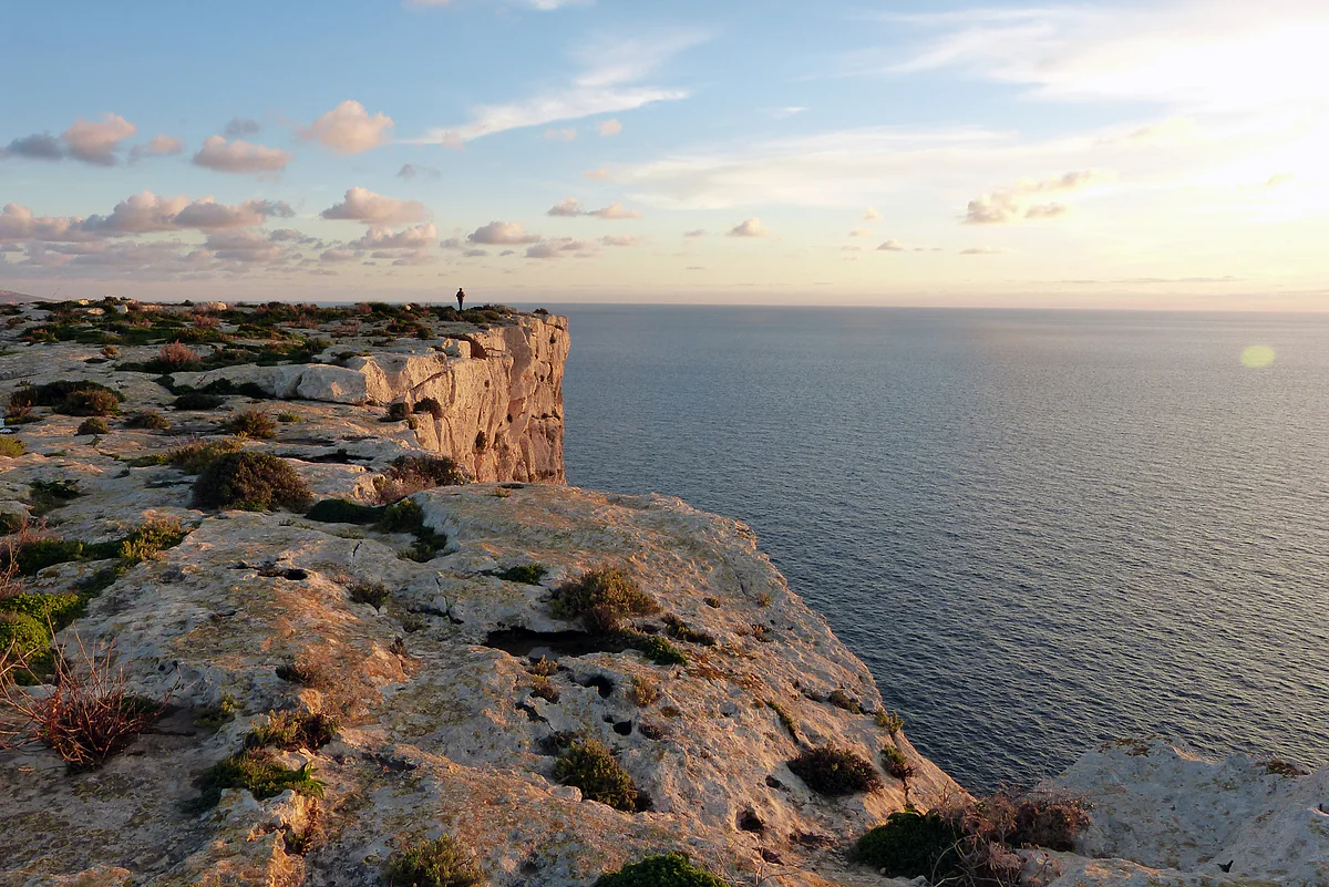
Dingli, island of Malta
The Dingli Cliffs, the highest coastline on the island of Malta
The Dingli Cliffs are the high western coast of Malta, with rock faces reaching 230 m above the sea according to Spain's Foreign Ministry and St Mary Magdalene Chapel on top. They're free to visit at any hour, and buses 52 and 56 run there from Valletta. For me they're the best sunset on the main island.
In 30 seconds
Full read: 3 min
- The Dingli Cliffs rise up to 230 m above the sea.
- They're free; St Mary Magdalene Chapel stands on top.
- Buses 52 and 56 run there from Valletta, via Rabat.
- Sunset is the time to go, and Buskett is right next door.
I'd arrive an hour before sunset, walk along the top towards the Magdalene chapel and stand still when the sun touches the water. I wouldn't lean over for a photo, because the view is just as good two metres back.

Before you go
What I would keep in mind
-
01 Most beautiful
The Magdalene chapel
Malta Public Transport picks out St Mary Magdalene Chapel, small and perched high on the cliffs, for its panoramic views. It's the landmark I'd use to structure the walk.
-
02 To save money
The best free thing in the west
There's nothing to pay to see the cliffs or walk along the top. A €2.50 summer bus ticket, valid for two hours, gets you there from Valletta.
-
03 Getting there
Add Buskett
Buses 52 and 56 also stop at Buskett, Malta's only semi-natural woodland according to BirdLife Malta. A shady stroll first, sunset after.
Buskett Gardens -
04 My tip
Be aware in hunting season
The UK government warns that in spring and autumn hunters with guns may be near country paths, from two hours before sunrise to two hours after sunset.
What I would book
If I could only pick one sunset on the island of Malta, it would be this one. The Dingli Cliffs are a wall of rock dropping into the Mediterranean on the west coast, with nothing between you and the horizon, and late in the afternoon the light does the rest. They cost nothing and there’s a bus from Valletta.
What the cliffs are like
The Spanish Foreign Ministry’s country profile says they reach 230 metres above sea level. Dingli’s local council gives a bigger number, but I’ll stick with the most recent official one. This is the high coast of a farming village that never lived off the sea, precisely because it sat too far above the water to make a living from fishing.
Malta Public Transport describes the area as a quiet rural retreat, good for nature lovers and walkers. On top stands St Mary Magdalene Chapel, small and simple, which the same website singles out for its views. It’s the landmark I’d use to plan the walk.
This coastline is protected. It’s part of a 2,315.1-hectare Natura 2000 site covering the cliffs of southern and western Malta, from Ċirkewwa to Bengħisa, and since 1998 the islands’ coastal cliffs have been among Malta’s candidates for World Heritage status.
A coastline with a history
The cliffs are more than scenery. Dingli’s local council notes that rock-cut graves from the Phoenician and Carthaginian period, almost 2,800 years old, have turned up in the area, later reused by the Romans. It also explains that this coast served for centuries as a natural defence. When corsairs raided the islands, after taking Gozo in 1551 and turning towards Malta, they found it very hard to land here and warned one another to avoid it.
I like to think about that as the sun goes down. The same rock face we photograph today is the reason a village of farmers could live on the edge of the sea without walls.
When should you go to the Dingli Cliffs?
At sunset, clearly. It’s a west-facing coast, and as the sun drops the rock turns gold. I’d arrive an hour before sunset to walk along the top in daylight and stay until the sun touches the water. They’re pleasant in the morning too, but they lose what makes them special.
In spring and autumn, bear the hunting season in mind. According to GOV.UK, hunters with guns can be about near country paths between two hours before sunrise and two hours after sunset. There’s no need to be alarmed, but I’d keep to the marked paths and away from the fields.
How do you get there?
Routes 52 and 56 leave Valletta bus terminus and run via Rabat to Dingli. You pay €2.50 for a single in the summer season, or €2 in winter, and it covers two hours of travel including changes; contactless works on board. From the airport, route 201 serves Dingli and Rabat. Coming from Buġibba, Malta Public Transport suggests the 186 to Rabat and then the 52 or 56. Cards and fares are explained in buses in Malta.
By car this is one of the areas where hiring really pays off, as you can link the cliffs, Buskett and Mdina in an afternoon. I couldn’t find official information on parking along the cliff top, so I won’t promise you a space.
More than a sunset
Right next door are Buskett Gardens, the woodland the Knights planted, served by the same 52 and 56 buses. I’d take a shady walk through the woods mid-afternoon and head up to the cliffs afterwards. The village of Dingli is a step away, and Mdina and Rabat a short bus ride, so all three fit into one day.
If coastal scenery is your thing, my guide to the most beautiful places in Malta compares this sunset with the one at Dwejra on Gozo, the only one I’d put in the same league.
What I’d avoid
The classic mistake is the photo. There’s no need to stand on the lip, since a few steps back you see exactly the same, and at that height it isn’t worth the risk. Nor would I try to get down to the sea, because I’m not aware of any official access. For a swim on the west coast, the beaches at Għajn Tuffieħa and Ġnejna are a different story.
Getting to the Dingli Cliffs
| From | How | Notes |
|---|---|---|
| Valletta | Bus 52 or 56 | Via Rabat |
| Rabat or Mdina | Bus 52 or 56 | Short ride |
| Airport | Bus 201 | Serves Dingli and Rabat |
| Buġibba | 186 to Rabat, then 52 or 56 | One change |
A day single is €2.50 in summer and €2 in winter (from 19 Oct), valid for two hours with transfers. Malta Public Transport and Malta International Airport.
The cliffs in numbers
| Item | Figure | Source |
|---|---|---|
| Maximum height | 230 m | Spanish Foreign Ministry, June 2026 |
| Highest point on Malta island | Ta' Dmejrek, 253 m | Spanish Foreign Ministry |
| Natura 2000 site | 2,315.1 ha, Ċirkewwa to Bengħisa | European Environment Agency |
| UNESCO Tentative List | Coastal Cliffs, since 1998 | UNESCO |
Test yourself
True or false?
0/4 Pick before you peek.
-
The Dingli Cliffs are over 300 metres high.
See the answer
False. Spain's Foreign Ministry country profile says they reach 230 metres above sea level. The local council quotes a higher figure, but the most recent official one is 230.
-
Malta's coastal cliffs are in the running for World Heritage status.
See the answer
True. The «Coastal Cliffs» have been on Malta's Tentative List since 1998, along with Mdina, the Citadel and four other sites.
-
You have to pay to see the cliffs.
See the answer
False. It's open coastline, free to visit at any hour.
-
The Dingli Cliffs are protected by the EU.
See the answer
True. They're part of a 2,315.1-hectare Natura 2000 site covering Malta's southern and western cliffs, from Ċirkewwa to Bengħisa.
- Maximum height
- 230 m
- Entry
- €0
- Added to UNESCO's Tentative List
- 1998
- Natura 2000 site covering the cliffs
- 2,315 ha
Map
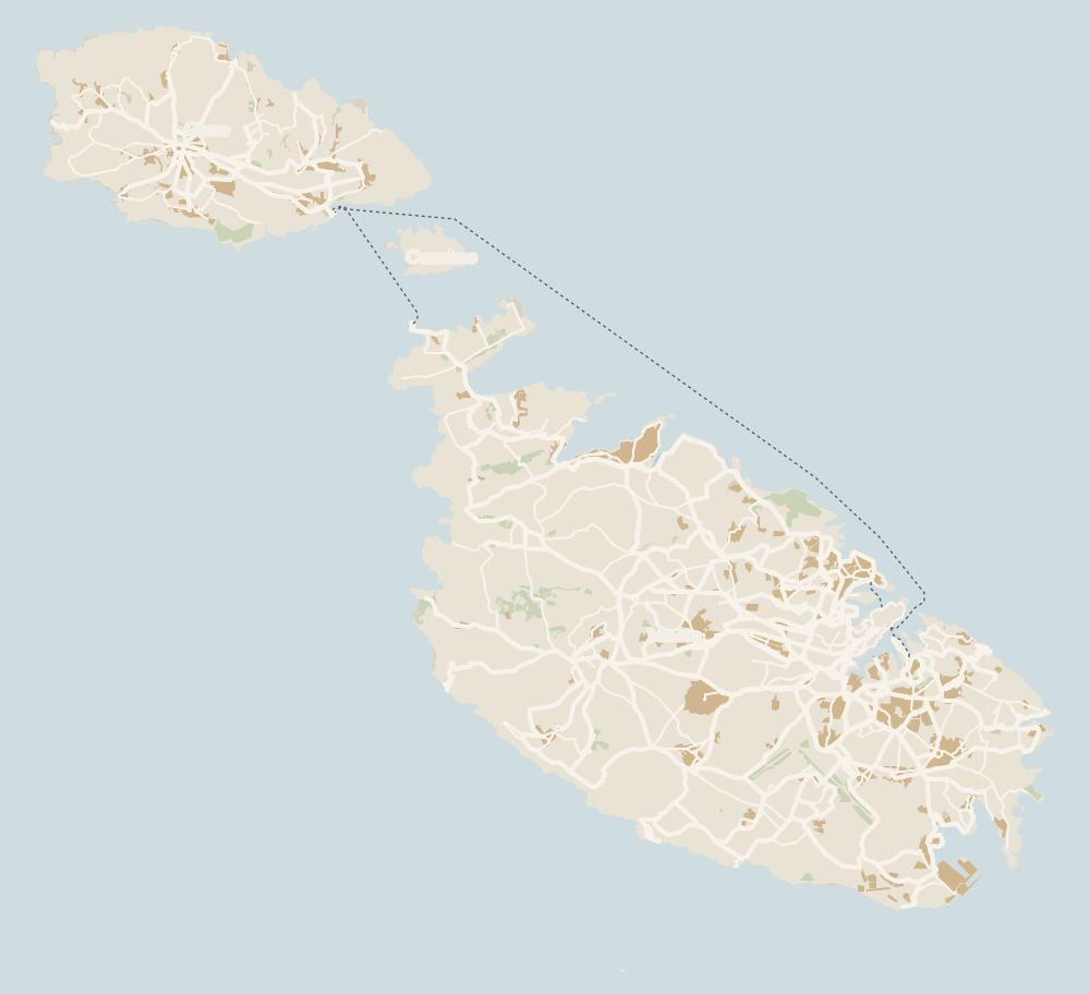
Where Dingli Cliffs is
Gozo lies to the north-west, across the channel the ferry crosses from Ċirkewwa, with Comino between the two islands. Every number opens its guide.
0 of 279 Malta guides
Your next stamp
- Dingli
- Weekend in Malta
- Walking and hiking
- Cruise stop
- Golden Bay
- Malta in a week
- Viewpoints
- Things to do in Malta
- Gozo
- Most beautiful places
- Comino
- Prettiest villages
- UNESCO World Heritage Sites
- Where is Malta
- The Maltese islands
- Towns and villages
- Island of Malta
- Blue Lagoon
- Fort Rinella
- Fort St Angelo
- Gardjola Gardens
- Ħal Saflieni Hypogeum
- Is Malta a country?
- Popeye Village
- Tarxien Temples
- Things to do in Gozo
- Valletta
- Esplora
- Gozo day trip
- Inquisitor's Palace
- Population
- St John's Co-Cathedral
- St Mary's Tower
- Grandmaster's Palace
- How big is Malta
- Maritime Museum
- Mellieħa Bay
- Fort St Elmo
- Language
- Malta at War Museum
- Paradise Bay
- Barrakka Gardens
- Red Tower
- Religion
- Malta government
- Saluting Battery
- MUŻA
- National Museum of Archaeology
- Underground Valletta
- Lascaris War Rooms
- Casa Rocca Piccola
- Malta in one day
- Three Cities
- Victoria
- Birgu
- Manoel Theatre
- Xagħra
- City Gate and Parliament
- Malta in three days
- Nadur
- Senglea
- Cospicua
- Malta in four days
- Qala
- Valletta Waterfront
- Għajnsielem
- Kalkara
- Malta in five days
- Paola
- Xewkija
- Sannat
- Tarxien
- Munxar
- Żabbar
- Fgura
- Fontana
- Kerċem
- Luqa
- Floriana
- Marsa
- Mellieħa
- The Citadel, Gozo
- Żebbuġ (Gozo)
- Ġgantija Temples
- Marsalforn
- Santa Luċija
- Ramla Bay
- San Lawrenz
- Xgħajra
- Xwejni salt pans
- Calypso's Cave
- Għarb
- Żejtun
- Għasri
- Gudja
- San Blas Bay
- Għaxaq
- Ħondoq Bay
- Marsaxlokk
- Kirkop
- Marsaxlokk Fish Market
- Mqabba
- St Peter's Pool
- Marsaskala
- Qrendi
- Żurrieq
- Beaches
- Comino ferry
- EU, Schengen and the euro
- Ħaġar Qim and Mnajdra
- Mdina
- Mġarr (Gozo)
- Blue Grotto
- Diving
- Entry requirements
- Mdina Cathedral
- Xewkija Rotunda
- Birżebbuġa
- Money and payments
- Palazzo Falson
- Safi
- Shipwrecks
- Ta' Ċenċ Cliffs
- Għar Dalam
- Mdina Dungeons
- Mġarr ix-Xini
- Prices and budget
- Snorkelling
- Boat trips
- Malta on a budget
- Playmobil FunPark
- Rabat (Malta)
- Xlendi
- Dwejra
- Gozo beaches
- History
- Siġġiewi
- St Paul's Catacombs
- Tipping
- Azure Window
- Domvs Romana
- Għar Lapsi
- Great Siege of 1565
- Plugs
- Limestone Heritage Park
- Second World War
- St Paul's Grotto
- Ta' Pinu Basilica
- Time zone
- Buskett Gardens
- Knights of Malta
- Mobile and roaming
- Wied il-Għasri
- Maltese cross
- Flag
- Żebbuġ
- Coat of arms
- Mtarfa
- Balzan
- National anthem
- Lija
- Malta facts
- Game of Thrones
- Iklin
- Attard
- Film locations
- Forts and fortifications
- San Anton Gardens
- Ta' Qali Crafts Village
- Victoria Lines
- Megalithic temples
- Catacombs
- Museums
- Where to eat
- Where to stay
- Churches
- Hotels in Valletta
- Restaurants in Valletta
- Hotels in Sliema
- Maltese food
- Restaurants in Marsaxlokk
- Hotels in St Julian's
- Pastizzi
- Hotels in Buġibba and Qawra
- Maltese rabbit stew
- Safety
- Hotels in Mellieħa
- Kinnie and Cisk
- Scams
- Gozo hotels
- Nightlife
- Tap water
- Boat parties
- Holiday packages
- Tourist tax
- All inclusive
- Gay Malta
- Sightseeing passes
- Apartments
- Malta with kids
- Public holidays
- How to get there
- Luxury
- Malta for couples
- Taxis and ride-hailing
- Weather
- Best time to visit
- Cycling
- English schools
- Flights
- Flights from Madrid
- Sea temperature
- Shopping and souvenirs
- Airport
- Free walking tours
- In winter
- Airport transfers
- Day trips and tours
- In summer
- Ferry from Sicily
- In January
- In February
- In March
- In April
- In May
- Getting around
- In June
- Buses
- July
- August
- Hop on hop off
- Gozo ferry
- September
- Gozo fast ferry
- October
- November
- Valletta ferries
- Car hire
- December
- Driving
- Events
- St Paul's Bay
- Village feasts
- Buġibba
- Christmas
- Easter
- Qawra
- Carnival
- Xemxija
- Fireworks festival
- Malta National Aquarium
- Isle of MTV
- St Paul's Islands
- Mosta
- Mosta Rotunda
- Naxxar
- Palazzo Parisio
- Għargħur
- Mġarr (Malta)
- Sliema
- Ta' Ħaġrat and Skorba Temples
- Għajn Tuffieħa Bay
- Tigné Point
- Ġnejna Bay
- St Julian's
- Paceville
- St George's Bay
- Gżira
- Msida
- Ta' Xbiex
- Pietà
- Pembroke
- Swieqi
- San Ġwann
- Birkirkara
- Ħamrun
- Santa Venera
- Qormi
Frequently asked questions
How do I get to the Dingli Cliffs from Valletta?
Take bus 52 or 56 from Valletta bus terminus; both run via Rabat to Dingli. A ticket is €2.50 in summer and lasts two hours, and contactless works on board.
When is the best time to visit the Dingli Cliffs?
Sunset. They face west, and at that hour the light rakes across the rock. I'd get there an hour before the sun goes down.
How high are the Dingli Cliffs?
Up to 230 metres above sea level, according to the Spanish Foreign Ministry's country profile of June 2026.
Can you walk from Rabat or Mdina to the cliffs?
I haven't found an official waymarked route with a distance. The easy option is bus 52 or 56, which links Rabat with Dingli in no time.
Can you walk from the Dingli Cliffs to the Blue Grotto?
People search for it a lot, but I have no official source for a distance or a marked path. By bus you'll need a change; by car the two fit easily into one day.
Is there parking at the Dingli Cliffs?
I couldn't find official information on parking at the cliffs. Buskett, next door, does have its own car park according to BirdLife Malta.
Can you swim at the Dingli Cliffs?
I'm not aware of any official access down to the sea, and at that height I wouldn't go looking. For a swim in the west, Għajn Tuffieħa or Ġnejna have proper beaches.
By
Tourism graduate with a master’s in Tourism Management and Planning from the University of Málaga, who has travelled across Europe. He writes every guide from official sources and his own judgement.
Published on . Facts checked on .
Sources
Photos: V. Epiney (CC BY-SA 2.0), via Wikimedia Commons.