Southern Harbour district
Fgura, a post-war town with Punic tombs
Fgura (Il-Fgura) is a residential town of 14,270 people just south of the Three Cities, most of it built after the Second World War. At 12,488 people per km² it's the fifth most densely populated locality in Malta. It has no ticketed sights, though Punic tombs found here are on show in Valletta, and good buses to the capital.
In 30 seconds
Full read: 2 min
- Fgura is a residential town of 14,270 people south of the Three Cities.
- It's the fifth most densely populated locality in Malta.
- It grew mostly after the Second World War and became a parish in 1965.
- Bus 91 links it with Valletta.
I'll be honest, Fgura isn't a sightseeing stop. If you've found a room here, treat it as a cheap base and head out to the Three Cities next door, or into Valletta by bus.

Before you go
What I would keep in mind
-
01 My tip
Very few licensed beds
The MTA register lists one guesthouse and 27 holiday lets in Fgura. If you're renting, check yours is on it.
-
02 Getting there
Right by the Three Cities
The local council says Fgura grew until it touched Bormla, Żabbar, Paola and Tarxien. The Three Cities are just up the road.
the Three Cities of Malta -
03 Most beautiful
The Punic finds are in Valletta
Objects from the six Punic tombs on Liedna Street are displayed at the National Museum of Archaeology in Valletta, not in Fgura.
National Museum of Archaeology in Valletta
What I would book
Fgura has a page here because it’s one of Malta’s 68 local councils, not because you need to go and see it. It’s a residential town of 14,270 people, according to the NSO, and the most useful thing I can do is tell you what it is and what to expect if you’re staying there.
A 1960s town with ancient roots
Visit Malta sums it up nicely. At first glance it looks like a new town built in the sixties, but underneath there are prehistoric origins, with old tombs in the area and hints of a Phoenician settlement. The local council pins down the key find, six Punic tombs on Liedna Street from the third and fourth centuries BC, whose contents are now displayed at the National Museum of Archaeology in Valletta. The street, incidentally, is named after the leafy plant painted on that pottery.
The town’s name has two explanations. One points to a ‘figura’, a roadside niche with an image of Our Lady of Mount Carmel on the road between Żabbar and Paola; the other to Gozitan families who brought the name of an area of Gozo called Fgura. Neither is documented, and the council says as much.
Growing in a hurry
After the war, Fgura became a fashionable, quieter place to live and houses sprang up everywhere. The council says the Carmelites’ first church opened in 1950, that Fgura only got its own parish on 21 January 1965, and that the present church went up between 1976 and 1988. Today Fgura runs into Bormla, Żabbar, Paola and Tarxien, and its density of 12,488 people per km² is the fifth highest in Malta by my reckoning from NSO figures.
Two corners with a story
The council points to two places in local life. In George Stevens Square stands a monument to that Maltese writer, a founder of a literary society, by the sculptor Alfred Camilleri Cauchi, who lives and works in Fgura; it went up on 6 September 1986. And there’s a public garden named after Reggie Miller, founder of the General Workers’ Union, opened on 28 March 1976. Neither is a tourist sight, but together they tell you what kind of place Fgura is, a working-class village that became a town within a few decades. With 14,270 residents it’s now the second-largest locality in the Southern Harbour district, behind only Żabbar.
Does it make sense to stay in Fgura?
Only if you find something that suits you, because there’s barely any choice. The MTA register lists one guesthouse and 27 holiday lets, and no hotels. In its favour are the location, a stone’s throw from the Three Cities, and the bus. Route 91 heads into Valletta via Paola, Marsa and Floriana, and the other way on to Żabbar and Marsaskala. If it’s the sea you’re after, beyond Żabbar on the coast lies Xgħajra, a village of 2,604 people with a seafront promenade.
Fgura in numbers
| Item | Figure | Source |
|---|---|---|
| Population (31 Dec 2025) | 14,270 | NSO |
| Population (31 Dec 2024) | 13,986 | NSO |
| Foreign residents | 3,003 (21%) | NSO |
| Density | 12,488 per km² | NSO |
| Licensed accommodation | 1 guesthouse and 27 holiday lets | MTA, 28 Sep 2026 |
Percentage and density ranking are my own calculations from NSO data. Only Sliema, Pietà, Isla (Senglea) and Gżira are more densely populated.
Test yourself
True or false?
0/3 Pick before you peek.
-
Fgura is the most densely populated place in Malta.
See the answer
False. At 12,488 people per km² it comes fifth, behind Sliema, Pietà, Isla and Gżira, on NSO figures.
-
Punic tombs have been found in Fgura.
See the answer
True. The local council describes six Punic tombs on Liedna Street, from the third and fourth centuries BC.
-
Fgura has been a parish since the Middle Ages.
See the answer
False. According to the council, it relied on Tarxien's parish until the archbishop created its own on 21 January 1965.
- Residents at the end of 2025
- 14,270
- People per km²
- 12,488
- Parish founded
- 1965
Map
Where Fgura is
Gozo lies to the north-west, across the channel the ferry crosses from Ċirkewwa, with Comino between the two islands. Every number opens its guide.
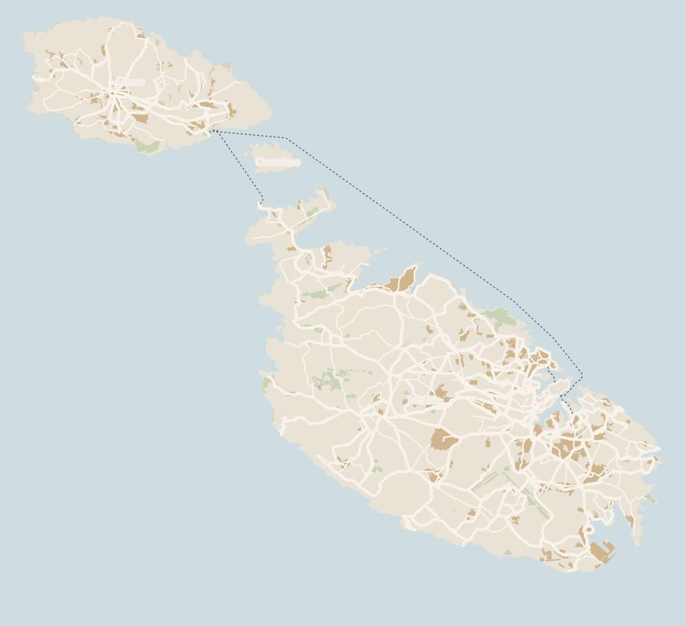 1Island of Malta 2Valletta 3Three Cities 4Kalkara 5Paola 6Tarxien 7Żabbar 8Fgura 9Luqa 10Floriana 11Marsa 12Mellieħa 13Santa Luċija 14Xgħajra 15Żejtun 16Gudja 17Għaxaq 18Marsaxlokk 19Kirkop 20Mqabba 21Marsaskala 22Qrendi 23Żurrieq 24Mdina 25Birżebbuġa 26Safi 27Rabat (Malta) 28Siġġiewi 29Dingli 30Żebbuġ 31Mtarfa 32Balzan 33Lija 34Iklin 35Attard 36Victoria Lines 37St Paul's Bay 38Mosta 39Naxxar 40Għargħur 41Mġarr (Malta) 42Sliema 43St Julian's 44Gżira 45Msida 46Ta' Xbiex 47Pietà 48Pembroke 49Swieqi 50San Ġwann 51Birkirkara 52Ħamrun 53Santa Venera 54Qormi
 Map data © OpenStreetMap contributors (ODbL)
- 1Island of Malta245 km² and 54 local councils
- 2VallettaFounded 1566, on the UNESCO list since 1980
- 3Three CitiesBirgu, Senglea and Cospicua
- 4Kalkara3,322 residents beside Birgu
- 5Paola10,064 residents above the Grand Harbour
- 6Tarxien10,266 residents and four temples
- 7ŻabbarSouthern Harbour district
- 8FguraSouthern Harbour district
- 9LuqaSouthern Harbour district
- 10Floriana2,043 residents at the capital's gates
- 11MarsaSouthern Harbour district
- 12MellieħaMalta's northern beach country
- 13Santa LuċijaSouthern Harbour district
- 14XgħajraEast coast, Southern Harbour district
- 15ŻejtunSouth Eastern district
- 16GudjaSouth Eastern district
- 17GħaxaqSouth Eastern district
- 18MarsaxlokkMalta's main fishing port
- 19KirkopSouth Eastern district
- 20MqabbaSouthern Malta, South Eastern district
- 21Marsaskala19,211 residents in the south east
- 22QrendiMalta's south coast
- 23ŻurrieqSouthern Malta, South Eastern district
- 24MdinaIsland of Malta, Western district
- 25BirżebbuġaSouth Eastern district, next to the Freeport
- 26SafiSouth Eastern district
- 27Rabat (Malta)Island of Malta, Western district
- 28SiġġiewiWestern Region, between Buskett and Għar Lapsi
- 29DingliIsland of Malta, Western district
- 30ŻebbuġWestern district, not the one on Gozo
- 31MtarfaIsland of Malta, Western district
- 32BalzanIsland of Malta, Western district
- 33LijaIsland of Malta, Western district
- 34IklinIsland of Malta, Western district
- 35AttardOne of central Malta's Three Villages
- 36Victoria LinesNamed in 1897 for Queen Victoria's Diamond Jubilee
- 37St Paul's BayLocal council in northern Malta
- 38MostaLocal council in central Malta
- 39NaxxarLocal council in northern Malta
- 40GħargħurLocal council in northern Malta
- 41Mġarr (Malta)Local council in western Malta
- 42SliemaIsland of Malta, Northern Harbour
- 43St Julian'sIsland of Malta, Northern Harbour
- 44GżiraIsland of Malta, Northern Harbour
- 45MsidaIsland of Malta, Northern Harbour
- 46Ta' XbiexIsland of Malta, Northern Harbour
- 47PietàIsland of Malta, Northern Harbour
- 48PembrokeIsland of Malta, Northern Harbour
- 49SwieqiIsland of Malta, Northern Harbour
- 50San ĠwannIsland of Malta, Northern Harbour
- 51BirkirkaraIsland of Malta, Northern Harbour
- 52ĦamrunIsland of Malta, Northern Harbour
- 53Santa VeneraIsland of Malta, Northern Harbour
- 54QormiIsland of Malta, inland from the Grand Harbour
0 of 279 Malta guides
Your next stamp
- Towns and villages
- Żabbar
- Tarxien
- Xgħajra
- Population
- Island of Malta
- Żurrieq
- Senglea
- Things to do in Malta
- Gozo
- Most beautiful places
- Comino
- Prettiest villages
- UNESCO World Heritage Sites
- Where is Malta
- The Maltese islands
- Blue Lagoon
- Fort Rinella
- Fort St Angelo
- Gardjola Gardens
- Ħal Saflieni Hypogeum
- Is Malta a country?
- Popeye Village
- Tarxien Temples
- Things to do in Gozo
- Valletta
- Esplora
- Golden Bay
- Gozo day trip
- Inquisitor's Palace
- St John's Co-Cathedral
- St Mary's Tower
- Grandmaster's Palace
- How big is Malta
- Maritime Museum
- Mellieħa Bay
- Fort St Elmo
- Language
- Malta at War Museum
- Paradise Bay
- Barrakka Gardens
- Red Tower
- Religion
- Malta government
- Saluting Battery
- MUŻA
- National Museum of Archaeology
- Underground Valletta
- Lascaris War Rooms
- Casa Rocca Piccola
- Malta in one day
- Three Cities
- Victoria
- Birgu
- Manoel Theatre
- Weekend in Malta
- Xagħra
- City Gate and Parliament
- Malta in three days
- Nadur
- Cospicua
- Malta in four days
- Qala
- Valletta Waterfront
- Għajnsielem
- Kalkara
- Malta in five days
- Malta in a week
- Paola
- Xewkija
- Sannat
- Munxar
- Fontana
- Kerċem
- Luqa
- Floriana
- Marsa
- Mellieħa
- The Citadel, Gozo
- Żebbuġ (Gozo)
- Ġgantija Temples
- Marsalforn
- Santa Luċija
- Ramla Bay
- San Lawrenz
- Xwejni salt pans
- Calypso's Cave
- Għarb
- Żejtun
- Għasri
- Gudja
- San Blas Bay
- Għaxaq
- Ħondoq Bay
- Marsaxlokk
- Kirkop
- Marsaxlokk Fish Market
- Mqabba
- St Peter's Pool
- Marsaskala
- Qrendi
- Beaches
- Comino ferry
- EU, Schengen and the euro
- Ħaġar Qim and Mnajdra
- Mdina
- Mġarr (Gozo)
- Blue Grotto
- Diving
- Entry requirements
- Mdina Cathedral
- Xewkija Rotunda
- Birżebbuġa
- Money and payments
- Palazzo Falson
- Safi
- Shipwrecks
- Ta' Ċenċ Cliffs
- Għar Dalam
- Mdina Dungeons
- Mġarr ix-Xini
- Prices and budget
- Snorkelling
- Boat trips
- Malta on a budget
- Playmobil FunPark
- Rabat (Malta)
- Xlendi
- Dwejra
- Gozo beaches
- History
- Siġġiewi
- St Paul's Catacombs
- Tipping
- Azure Window
- Domvs Romana
- Għar Lapsi
- Great Siege of 1565
- Plugs
- Limestone Heritage Park
- Second World War
- St Paul's Grotto
- Ta' Pinu Basilica
- Time zone
- Buskett Gardens
- Knights of Malta
- Mobile and roaming
- Wied il-Għasri
- Dingli
- Maltese cross
- Dingli Cliffs
- Flag
- Żebbuġ
- Coat of arms
- Mtarfa
- Balzan
- National anthem
- Lija
- Malta facts
- Game of Thrones
- Iklin
- Attard
- Film locations
- Forts and fortifications
- San Anton Gardens
- Ta' Qali Crafts Village
- Victoria Lines
- Megalithic temples
- Catacombs
- Museums
- Where to eat
- Where to stay
- Churches
- Hotels in Valletta
- Restaurants in Valletta
- Hotels in Sliema
- Maltese food
- Restaurants in Marsaxlokk
- Viewpoints
- Hotels in St Julian's
- Pastizzi
- Walking and hiking
- Hotels in Buġibba and Qawra
- Maltese rabbit stew
- Safety
- Hotels in Mellieħa
- Kinnie and Cisk
- Scams
- Gozo hotels
- Nightlife
- Tap water
- Boat parties
- Holiday packages
- Tourist tax
- All inclusive
- Gay Malta
- Sightseeing passes
- Apartments
- Malta with kids
- Public holidays
- How to get there
- Luxury
- Malta for couples
- Taxis and ride-hailing
- Weather
- Best time to visit
- Cycling
- English schools
- Flights
- Flights from Madrid
- Sea temperature
- Shopping and souvenirs
- Airport
- Free walking tours
- In winter
- Airport transfers
- Day trips and tours
- In summer
- Ferry from Sicily
- In January
- Cruise stop
- In February
- In March
- In April
- In May
- Getting around
- In June
- Buses
- July
- August
- Hop on hop off
- Gozo ferry
- September
- Gozo fast ferry
- October
- November
- Valletta ferries
- Car hire
- December
- Driving
- Events
- St Paul's Bay
- Village feasts
- Buġibba
- Christmas
- Easter
- Qawra
- Carnival
- Xemxija
- Fireworks festival
- Malta National Aquarium
- Isle of MTV
- St Paul's Islands
- Mosta
- Mosta Rotunda
- Naxxar
- Palazzo Parisio
- Għargħur
- Mġarr (Malta)
- Sliema
- Ta' Ħaġrat and Skorba Temples
- Għajn Tuffieħa Bay
- Tigné Point
- Ġnejna Bay
- St Julian's
- Paceville
- St George's Bay
- Gżira
- Msida
- Ta' Xbiex
- Pietà
- Pembroke
- Swieqi
- San Ġwann
- Birkirkara
- Ħamrun
- Santa Venera
- Qormi
Frequently asked questions
What is there to see in Fgura?
Official sources list no ticketed sights. There's a modern Carmelite parish church, opened in 1988, and six Punic tombs were found on Liedna Street; their contents are in the National Museum of Archaeology in Valletta.
Where is Fgura?
Just south of the Three Cities. Visit Malta says it borders the Cottonera Lines to the north, Żabbar to the south and Tarxien to the west.
How do I get from Fgura to Valletta?
Route 91 links Valletta and Marsaskala via Floriana, Marsa, Paola, Fgura and Żabbar. There's also a route that terminates in Fgura, the 95.
Where does the name Fgura come from?
The local council gives two theories. One is the 'figura', a roadside niche with an image of Our Lady of Mount Carmel on the way from Żabbar to Paola; the other is Gozitan settlers bringing the name of an area of Gozo called Fgura.
How many people live in Fgura?
14,270 on 31 December 2025, according to the NSO, including 3,003 foreign residents. A year earlier there were 13,986.
By
Tourism graduate with a master’s in Tourism Management and Planning from the University of Málaga, who has travelled across Europe. He writes every guide from official sources and his own judgement.
Published on . Facts checked on .
Sources
Photos: Leandro Neumann Ciuffo (CC BY 2.0), via Wikimedia Commons.