Interactive map and how to get your bearings
Vatican City map, a country you can cross on foot
Vatican City sits inside Rome, near the right bank of the Tiber, and covers 44 hectares, half of them gardens. Visitors use two main entrances, the museums on Viale Vaticano to the north and the basilica through St Peter's Square. Further down the page is my interactive map, with a numbered point for each visit.
I'd build my mental map around two anchors, the dome and the museum entrance, because almost everything you can visit lies between them. And I wouldn't hunt for a shortcut inside, because there's no documented passage from one to the other for anyone on a standard ticket, so you walk round by the street.

Before you go
What I would keep in mind
-
01 Getting there
Two entrances, two metro stops
Starting with the museums, get off line A at Ottaviano or Cipro and head for Viale Vaticano. Starting with the basilica, go in through the square and clear security in the right-hand arc, as you face the façade.
How to get to Vatican City from Rome and the airports -
02 Most beautiful
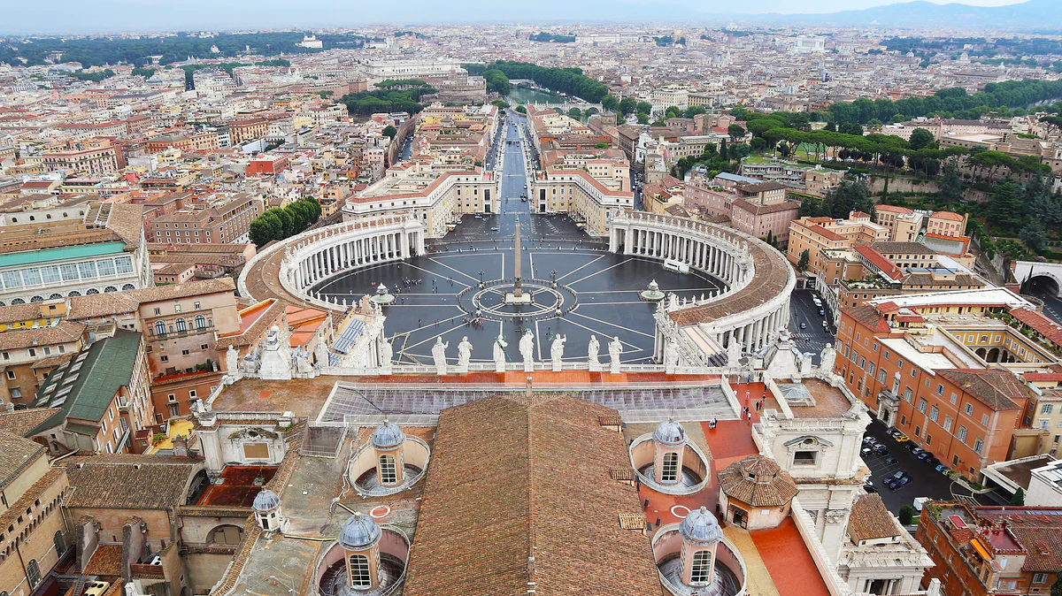
The best map is the view from the dome
From the top you see the square wrapped in its colonnade, Via della Conciliazione running towards the Tiber and, on the other side, the gardens. No map explains the size of the state as well as ten minutes up there.
St Peter's Dome -
03 My tip
The border is set into the paving
There's no wall across the square. The state's website says the boundary is marked by a strip of travertine, and the Lateran Treaty lets Italian police operate up to the foot of the basilica steps.
St Peter's Square -
04 My tip
Half the country is garden, and it's guided only
The gardens cover about 22 hectares, half the territory, and you can only go round them on an official walking tour or the open-top bus. On the map they're the big green patch west of the basilica.
Vatican Gardens
What I would book
- Data eSIMHolafly Data to keep the map on your phone Between the dome and the Museums entrance you go round by the street, with no shortcut inside. With data on your phone you can follow the route without wifi.
- Places to stayBooking.com Staying in Borgo, between the two anchors Borgo sits between the colonnade and the castle, a few minutes' walk from the square. For a trip built around the Vatican, that's where I'd stay.
A map of the Vatican doesn’t behave like any other country map. The whole state fits on a phone screen at street scale, and what you need from it isn’t the borders so much as the doors. My map for this guide sits further down, below the cards. First, here’s where the state is, how it’s laid out and how to move around it without losing half a morning walking round the walls.
Where is Vatican City?
Inside Rome. The state’s website places it near the right bank of the Tiber, on a slight rise, with the city on every side. From the historic centre you cross the river and walk, and the clearest approach is over Ponte Sant’Angelo to the castle and on along Via della Conciliazione, joined to the castle since 23 December 2024 by a pedestrian square and ending face on to St Peter’s Square.
By metro, line A drops you at Ottaviano or Cipro, the two stops the museums give as their own. Buses, airport trains and fixed-fare taxis are all covered in getting to the Vatican. Around the walls are the two Roman districts I’d use as a base, Borgo, right up against the colonnade, and Prati, further north.
How to use the interactive map on this page
The map is drawn from OpenStreetMap data, and I’ve built it as a tool rather than a picture. The dashed line is the state border and the hatched area is its territory. Green patches are gardens and parks, buildings are in a darker tone and the fine dashed line is the railway. On top sit numbered points, one for each of my guides with a specific location, from the museums to the necropolis.
Every point is a link. Tap it and you go to that visit’s page, and the list alongside says the same in text, with matching numbers. Hover over one and its partner lights up, so you can look something up in the list first and then see where it falls.
How 44 hectares are shared out
The state covers 0.44 km², and half of it, about 22 hectares, is the Vatican Gardens, filling a good part of the western side of the map. That surprises a lot of people. The smallest country in the world is, above all, a walled garden.
The rest is split between the basilica and its square on the side facing Rome, the palaces and courtyards of the museums to the north, and a string of buildings that aren’t open to visitors. How many people live there, how it’s governed and why it counts as a country are all in is Vatican City a country?.
What’s open, what’s booked and what’s off limits
Open without booking are the square and St Peter’s Basilica with its Grottoes, plus the dome, which you pay for separately. The Vatican Museums and the Sistine Chapel need a ticket, and the Vatican necropolis under the basilica needs a booking and a guide. The gardens are official tour only.
Off limits is nearly everything else. The Pope’s apartment, the Sala Regia and the Pauline Chapel don’t appear in any visit on the official ticket site. The way I’d sum it up, an ordinary visitor gets to know the half of the state that faces the city and sees the other half from above, from the dome.
Finding your way with the dome and the colonnade
My trick is to use the dome as north. You can see it from plenty of the surrounding streets, and as long as it’s in view you know where the square is. The other landmark is the colonnade. Facing the front of the basilica, security is in the right-hand arm and the post office in the left. The necropolis entrance is on the left as well, along Via Paolo VI. Two smaller doors are worth knowing about. Worshippers have their own route, the Percorso Oranti, signposted in yellow from Via di Porta Angelica and leading in through the Grottoes, and the Roman tombs of the Via Triumphalis, a different necropolis, are reached through the Portone di Santa Rosa on Piazza del Risorgimento.
The museum entrance lies to the north, on Viale Vaticano, and there’s no way to link it to the basilica from inside on a standard ticket. You come out and walk round. Unofficial guides reckon about 800 metres and 10 to 15 minutes, and I’d allow a bit more with children or in the heat.
Beyond the walls, what the map doesn’t show
Some Holy See property sits outside the state and so outside this map. The basilicas of St John Lateran, Santa Maria Maggiore and St Paul Outside the Walls belong to it, with immunities, but they stand on Italian soil. And 24 kilometres away, by Lake Albano, is Castel Gandolfo, the Pope’s summer palace, which works the same way. Look for them on a Vatican map and you won’t find them, because they aren’t the Vatican.
The Vatican entrances a visitor actually uses
| Entrance | Where it is | What it's for |
|---|---|---|
| Museum entrance | Viale Vaticano | Museums, Sistine Chapel, gardens and official guided tours |
| Square security check | Right-hand arc of the colonnade, facing the basilica | Basilica, Grottoes and dome |
| Via Paolo VI | Left-hand colonnade, entrance to the Audience Hall | Necropolis (Scavi), booked in advance |
| St Anne's Gate | To the right of the colonnade | Office for papal blessing parchments |
| Portone di Santa Rosa | Piazza del Risorgimento | Via Triumphalis necropolis, guided |
| Percorso Oranti | Via di Porta Angelica, signposted in yellow | Worshippers; goes in through the Grottoes |
Details from museivaticani.va, basilicasanpietro.va, tickets.museivaticani.va and elemosineria.va, checked on 24 September 2026.
What you can visit inside the state, and how
| Area | Open to visitors? | How |
|---|---|---|
| St Peter's Square | Yes | Free; the Lateran Treaty keeps it normally open to the public |
| Basilica and Grottoes | Yes | Free, after the security check |
| Dome | Yes | €17 by the stairs or €22 with the lift, basilica included |
| Museums and Sistine Chapel | Yes | €20 at the ticket office or €25 online |
| Necropolis under St Peter's | Yes, booked | €20 with a guide, age 10 and over |
| Vatican Gardens | Official tour only | On foot with the museums or by open-top bus |
| Papal apartment, Sala Regia and Pauline Chapel | Not on sale | Not in any product on the official ticket site |
Official 2026 prices. Castel Gandolfo is 24 kilometres from Rome and isn't state territory, but a Holy See property in Italy.
Map
A whole country you can cross on foot
Tap a point to open its guide.
Map data © OpenStreetMap contributors (ODbL)
- 1 Sistine ChapelInside the Vatican Museums
- 2 Vatican MuseumsSeven kilometres of galleries in Vatican City
- 3 St Peter's BasilicaConsecrated in 1626, 400 years old this year
- 4 St Peter's SquareFree, open to all, and technically another country
- 5 St Peter's DomeMichelangelo's dome, 136.57 metres to the cross
- 6 Vatican NecropolisThe Scavi tour, by request and with a guide
- 7 Vatican Gardens22 hectares behind the museums
- 8 Swiss GuardWho guards the Pope, and why they are Swiss
- 9 Seeing the PopePope Leo XIV, Wednesdays and Sundays
- 10 Apostolic PalaceThe Sistine Chapel is inside, though it doesn't feel like it
- 11 Papal audiencePope Leo XIV in St Peter's Square
- 12 AngelusSt Peter's Square, Sundays at noon
- 13 Where the Pope livesApostolic Palace, Santa Marta and Castel Gandolfo
- 14 Mass at St Peter'sNine Masses every weekday, all free
- 15 ChristmasThe 2026 nativity and tree are already announced
- 16 EasterThe 2026 timetable and what we know of 2027
- 17 Train stationDesigned by Giuseppe Momo, opened in 1933
- 18 Pharmacy, shop and petrolOpen to anyone with a paper prescription
0 of 88 Vatican City guides
Your next stamp
- Gallery of Maps
- Vatican Museums map
- St Peter's Square
- Vatican Museums
- Things to do
- Photography
- Where to stay
- Sistine Chapel
- One day
- Tickets
- Two days
- St Peter's Basilica
- St Peter's Dome
- Vatican Necropolis
- Vatican Gardens
- Swiss Guard
- Seeing the Pope
- How to visit
- Castel Gandolfo
- Where to eat
- Free and cheap
- Apostolic Palace
- Scams to avoid
- Getting there
- Money and payments
- Exclusive experiences
- Papal audience
- Angelus
- Who painted it
- Where the Pope lives
- Dress code
- Facts
- Opening hours
- Flag
- Post office and stamps
- Is it a country?
- Vatican Grottoes
- History
- Pietà
- Baldachin
- Ceiling
- Chair of St Peter
- Last Judgement
- Raphael Rooms
- Architecture and architects
- Holy Door
- Library and Archives
- Bramante Staircase
- Facade and balcony
- Mass at St Peter's
- Pio Clementino Museum
- Papal blessing
- Vatican Pinacoteca
- Catacombs
- Gallery of Tapestries
- Gallery of the Candelabra
- Egyptian and Etruscan Museums
- Obelisk
- Bernini's colonnade
- How long you need
- Night opening
- Chiaramonti and Braccio Nuovo
- Christmas
- Anima Mundi Museum
- Easter
- Carriage Pavilion
- Gift shops and souvenirs
- With kids
- Best time to visit
- Courtyard of the Pine Cone
- Train station
- Accessible travel
- Vatican Observatory
- Borgia Apartment
- Modern art collection
- Papal Palace
- Barberini Gardens
- Facts
- Getting there
- Holy See
- Lake Albano
- Police and army
- Passport
- Pharmacy, shop and petrol
- What Vatican means
- Papal tombs
- List of popes
Frequently asked questions
Where is Vatican City?
Inside Rome, near the right bank of the Tiber on a slight rise, according to the state's own website. You reach it on metro line A, getting off at Ottaviano or Cipro, or on foot from Castel Sant'Angelo along Via della Conciliazione, which ends in St Peter's Square.
Is Vatican City in Rome or a separate country?
Both. It's physically inside Rome, but it has been a sovereign state since the Lateran Pacts of 1929. There is a border with Italy, just no checks on it, so you walk from one country into the other without showing a passport.
How big is Vatican City?
0.44 km², or 44 hectares. About 22 of those are the Vatican Gardens, half the territory. On a map of Europe it barely registers as a dot inside Rome, which is why the maps that actually help are drawn at street level.
How do you get from the Vatican Museums to St Peter's Basilica?
By the street. The museums' website lists no inside route for visitors on a standard ticket, so you leave, walk round the outside of the state to the square and go through security. Unofficial guides put it at about 800 metres, 10 to 15 minutes on foot.
Where is the Sistine Chapel in Vatican City?
Inside the Vatican Museums, which is the only way in to see it, and on the map it sits just north of the basilica. Close as it is, there's no access from the square, so you need a museum ticket.
Is there a map of the Vatican Museums?
Yes, the museums publish a PDF floor plan on their official site. The map on this page is a different thing, covering the whole state so you can place the museums in relation to the basilica, the square, the gardens and the entrances.
By
Tourism graduate with a master’s in Tourism Management and Planning from the University of Málaga, who has travelled across Europe. He writes every guide from official sources and his own judgement.
Published on . Facts checked on .
Sources
Photos: Maksim Sokolov (maxergon.com) (CC BY-SA 4.0), via Wikimedia Commons.