3.6 km that close when the wind gets up
The Cap d'Ail coastal path, walking from Monaco to Mala beach
The Cap d'Ail coastal path runs 3.6 km along the shore between Marquet beach, by the harbour on the Monaco border, and Mala beach. It's free, the tourist office puts it at 90 minutes on average and the first 1.5 km can be done in a wheelchair with help. The town hall shuts it with 13 gates when the wind is strong or the sea is rough.
In 30 seconds
Full read: 3 min
- The Cap d'Ail coastal path runs 3.6 km from Marquet beach to Mala beach.
- It's free and the tourist office gives it 90 minutes on average.
- The first 1.5 km, to Pointe des Douaniers, can be done in a wheelchair with help.
- It has 13 gates that close in strong wind or rough seas.
- Dogs on a lead; bikes and scooters not allowed.
I'd walk it east to west, starting at Marquet with Monaco behind me, and finish with a swim at Mala. I'd go early, because in summer around 800 people a day pass along here, and before setting off I'd check whether it's blowing hard, since that's when the gates close.

Before you go
What I would keep in mind
-
01 Most beautiful
Belle Époque villas and an old millstone quarry
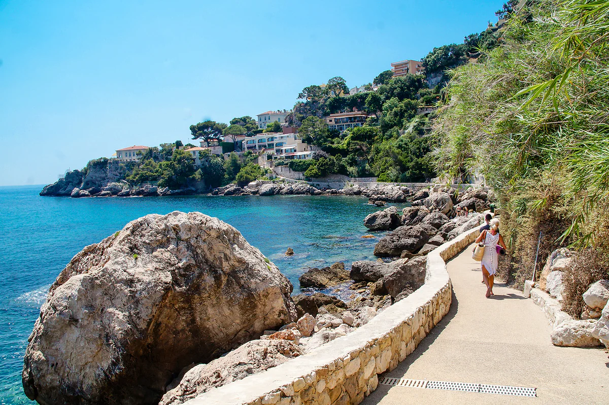
The town hall highlights the Mediterranean plants, an ancient millstone quarry "still shrouded in mystery" and the gardens of the Belle Époque villas that peer over the path.
-
02 To save money
Free, and you walk straight out of the Principality
Marquet beach sits by Cap d'Ail harbour, on the border with Fontvieille. You leave Monaco on foot and as soon as you cross you're on the path, no ticket of any kind.
Monaco on a budget -
03 My tip
If the gate is shut, you don't go through
The path has 13 gates that council staff close in violent wind or heavy seas. The town hall asks everyone to respect them, and on a rocky coast I wouldn't chance it.
-
04 Getting there
Back by bus or train
From Mala you climb the steps towards the village, where the ZOU! 600 bus and the railway station take you back to Monaco or on to Nice.
Nice to Monaco by train, bus or taxi
My priorities
Unmissable
- Check the wind and sea before setting off, as the path closes in bad weather
- Pack swimwear to finish at Mala beach
If you have time
I would skip
- Climbing over a closed gate
- Bringing a bike or a scooter, which aren't allowed
What I would book
My ranking, scored
The beaches along the path, with my scores
My own scores out of 10, and they're opinion. What counts is the water and setting, how easy it is to reach and what the town hall publishes about each beach.
0 of 4 seen
-
Mala beach
Fine sand and round pebbles in a rocky cove at the end of the path. The town hall calls it legendary, and it's where I'd swim at the finish.
9.2 out of 10
-
Marquet beach
Family-friendly, by the harbour, accessible and with beach wheelchairs in July and August if you book. It's the starting point, not the destination.
7.6 out of 10
-
Pointe des Douaniers beach
The "plage des chiens", where dogs are tolerated, just west of the point. Useful if you're walking with yours.
7.0 out of 10
-
Les Pissarelles beach
Wild, ringed by rocks and hard to reach, only down a flight of steps from the Basse Corniche. For anyone after solitude who doesn't mind the climb.
6.8 out of 10
Of everything you can do on foot from Monaco, this is the walk I wouldn’t skip. You leave the Principality through Fontvieille, cross a border you barely notice and within minutes you’re walking among rocks, pines and villas from another era, with no shops and no cars, towards a cove that begs for a swim. Here’s how the path unfolds section by section, which beaches it touches and what’s worth knowing before you set off.
A coastal path with gates
Cap d’Ail town hall and Nice’s tourist office give the same length, 3.6 km between Marquet beach and Mala beach. The tourist office rates it as easy and puts the average time at 90 minutes, two hours in a group. There are information panels along the way, a picnic area and guided walks on request.
What hardly anyone mentions is that the path closes. It has 13 safety gates that council staff shut when the wind is violent or the sea is heavy, and the town hall explicitly asks people not to climb over them. So before going, I’d check the wind and wave forecast, and if there’s been a storm the day before, I’d have a plan B. Bikes and scooters aren’t allowed either, and dogs must be on a lead.
Where does the Cap d’Ail coastal path start?
At the eastern end, on Marquet beach. It sits right by Cap d’Ail harbour, which adjoins Monaco’s Fontvieille district, so you can walk there from the Principality. If you’re driving, the Brise Marine car park is on avenue Marquet, next to the start of the path. The beach is family-friendly, non-smoking and accessible; in July and August it has two Tiralo beach wheelchairs and a Hippocampe, booked through the sports department. Overlooking that same harbour is the Riviera Marriott La Porte de Monaco hotel, if you’d like to sleep with the path on your doorstep.
The first stretch, from Marquet to Pointe des Douaniers, is 1.5 km long and can be done in a wheelchair with help, according to the tourist office. That strikes me as a valuable detail, because it makes the walk possible for families with a pushchair or anyone who’d rather avoid steps.
What you pass along the way
The town hall sums it up in three things. Uncommon Mediterranean plants, an ancient millstone quarry that, in its words, remains “shrouded in mystery”, and the gardens of Belle Époque villas peering over the path. The Lumière brothers, Colette and Churchill all spent time in Cap d’Ail, and you can sense that past in the houses.
Just west of Pointe des Douaniers is the beach the town hall calls “la plage des chiens”, because dogs are tolerated there. To reach it without walking the whole path, the Cap Fleuri car park is 200 metres from the path. Further on, off the path and reached only by a flight of steps from the Basse Corniche, lies Les Pissarelles, a wild beach hemmed in by rocks.
Mala beach, the reward at the end
Mala is a cove of fine sand and round pebbles tucked among rocks, non-smoking, and it held a Blue Flag in 2017. The town hall itself calls it legendary, and to me it’s the reason to walk the path in this direction. You finish and you swim. Besides the path, you can get down to it by the Mala steps, beside the Eden residence, or the Solitude steps, and for parking nearby there’s avenue Pierre Weck and avenue François de May.
The tourist office mentions seafront restaurants along the way. Since I haven’t found a reliable source to point you to any one of them, I’d pack water and a bite to eat.
When to go, and how to get back
From June to September, according to the town hall, close to 800 people a day walk this stretch of coast. If you can, go early; it’s an exposed coastal path and in summer the sun beats down. Spring and autumn are when I’d enjoy it most, always checking the wind first.
To get back, from Mala you climb the steps towards the village, where you’ll find the railway station and the ZOU! 600 bus, at €2.20 bought in advance, to Monaco or Nice; the timetable details are in the Nice to Monaco journey. If you’ve still got energy, Villa Les Camélias and the rest of the village are in things to do in Cap d’Ail, and further ideas that won’t cost a penny sit in Monaco on a budget.
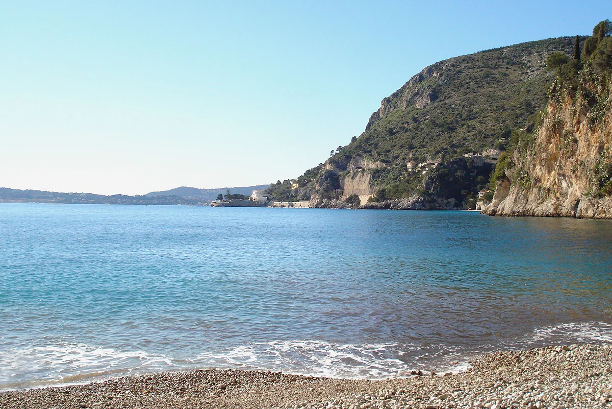
Mala beach in Cap-d'Ail, a pebble cove with turquoise water surrounded by cliffs and the headland beyond.
The path at a glance
| Section or detail | Information |
|---|---|
| Start | Marquet beach, by the harbour and the Monaco border |
| Pointe des Douaniers | End of the accessible section (1.5 km); beach where dogs are tolerated |
| Finish | Mala beach, in a rocky cove |
| Parking at the start | Brise Marine, avenue Marquet |
| Parking halfway | Cap Fleuri, 200 m from the path |
| Parking near Mala | Avenue Pierre Weck and avenue François de May |
| Closures | 13 gates, shut in strong wind or heavy seas |
Cap d'Ail town hall (seafront page) and Nice Côte d'Azur tourist office, checked on 25-09-2026.
The four beaches on the path
| Beach | What it's like | Access |
|---|---|---|
| Marquet | Family beach by the harbour; no smoking | Accessible; Tiralo and Hippocampe beach wheelchairs in July and August, book on 04 93 78 96 40 |
| Pointe des Douaniers | Dogs tolerated | Via the path; Cap Fleuri car park |
| Les Pissarelles | Wild, among rocks | Steps from the Basse Corniche only |
| Mala | Fine sand and round pebbles; no smoking | The path, or the Mala and Solitude steps |
Cap d'Ail town hall. For water quality at Mala, Marquet and Pissarelles, the town hall points to its bathing water profile.
Test yourself
True or false?
0/4 Pick before you peek.
-
You can cycle the Cap d'Ail coastal path.
See the answer
False. The town hall bans all two-wheelers, bikes and scooters included. Dogs are allowed, on a lead.
-
The path can be closed in bad weather.
See the answer
True. It has 13 safety gates that council staff close in violent wind or rough seas.
-
Marquet beach is on the Monaco border.
See the answer
True. The town hall places it next to Cap d'Ail harbour, on the border with Monaco. The harbour adjoins Fontvieille.
-
The whole path is wheelchair accessible.
See the answer
False. Only the first section, from Marquet beach to Pointe des Douaniers, around 1.5 km, and with assistance, according to the tourist office.
- From Marquet beach to Mala beach
- 3.6 km
- Average time, according to the tourist office
- 90 min
- Gates that close in bad weather
- 13
- Walkers a day from June to September, per the town hall
- 800
0 of 30 France guides
Your next stamp
- Cap-d'Ail
- Roquebrune-Cap-Martin
- Beaulieu-sur-Mer
- Riviera Marriott
- Saint-Jean-Cap-Ferrat
- Aparthotel Adagio
- Èze Exotic Garden
- Lemon Festival
- Monte-Carlo Beach
- Monte-Carlo Golf Club
- Villefranche beaches
- Villefranche-sur-Mer
- Cruise port
- Menton beaches
- Nietzsche Path
- Roquebrune castle
- Beausoleil
- Getting to Èze
- Monte-Carlo Country Club
- Where to stay in Menton
- Where to stay in Villefranche
- Menton
- Menton weather
- Villefranche weather
- Where to stay in Èze
- Cocteau museum, Menton
- Èze
- Menton gardens
- La Turbie
Frequently asked questions
How long is the Cap d'Ail coastal path?
3.6 km, from Marquet beach, next to Monaco, to Mala beach. The town hall and the Nice Côte d'Azur tourist office give the same figure.
How long does the Cap d'Ail coastal walk take?
The tourist office reckons 90 minutes on average on your own and two hours in a group. I'd allow a bit longer if you're stopping for a swim.
Can you walk the Cap d'Ail path from Monaco?
Yes. It starts at Marquet beach, right by Cap d'Ail harbour and Monaco's Fontvieille district. You walk out of the Principality and at the border you're on the path.
Are dogs allowed on the Cap d'Ail coastal path?
Yes, on a lead, according to the town hall. The beach at Pointe des Douaniers, just west of the point, is the "plage des chiens", where dogs are tolerated.
Is the Cap d'Ail coastal path always open?
No. It has 13 safety gates that council staff close in violent wind or rough seas, and climbing over them is forbidden.
Is the path wheelchair accessible?
The first stretch, from Marquet beach to Pointe des Douaniers, around 1.5 km, is, with assistance, according to the tourist office. Marquet beach is accessible too.
What is Mala beach in Cap d'Ail like?
A cove of fine sand and round pebbles among the rocks, no smoking, with a Blue Flag in 2017 according to the town hall. You reach it by the path or down the Mala and Solitude steps.
By
Tourism graduate with a master’s in Tourism Management and Planning from the University of Málaga, who has travelled across Europe. He writes every guide from official sources and his own judgement.
Published on . Facts checked on .
Sources
Photos: Bureau d'information Cap d'Ail (CC BY-SA 4.0); Gilbert Bochenek (Public domain), via Wikimedia Commons.